![](/images/other/stat-length.png)
![Excursión Senderismo Favières - LP80_HAMLET-MORLAY_9,6Km - Photo](https://media.geolcdn.com/t/1900/400/a6a34585-99df-4b8f-88a4-9490118b99dd.jpg&format=pjpeg&maxdim=2)
LP80_HAMLET-MORLAY_9,6Km
BAIE de SOMME & alentours
Autour de la Baie à pieds
![Longitud](/images/other/stat-length.png)
Longitud
9,6 km
![Altitud máxima](https://static1.geolcdn.com/siteimages/upload/files/1508320355ic_sort_altitude_max_24dp.png)
Altitud máxima
7 m
![Desnivel positivo](https://static1.geolcdn.com/siteimages/upload/files/1508320355ic_sort_den_pos_24dp.png)
Desnivel positivo
27 m
![Km-Effort](/images/other/stat-length.png)
Km-Effort
10 km
![Altitud mínima](https://static1.geolcdn.com/siteimages/upload/files/1508320355ic_sort_altitude_min_24dp.png)
Altitud mínima
1 m
![Desnivel negativo](https://static1.geolcdn.com/siteimages/upload/files/1508320355ic_sort_den_neg_24dp.png)
Desnivel negativo
27 m
![Boucle](https://static1.geolcdn.com/siteimages/upload/files/16400158638029165_repeat_loop_refresh_sync_direction_icon.png)
Boucle
Sí
Fecha de creación :
2020-08-03 14:48:32.32
Última modificación :
2023-10-03 19:01:16.985
![Senderismo](https://static1.geolcdn.com/sitytour/trail-icons/101.png)
2h14
Dificultad : Medio
![Escanee este código QR para abrir la excursión en la aplicación SityTrail](https://capi.geolives.com/qq0zvz2zws4bq2lad0pu/sitytour/trails/2500755/qr.png?size=200)
Aplicación GPS de excursión GRATIS
A propósito
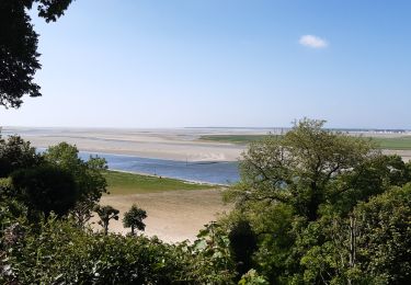
Ruta Senderismo de 9,6 km a descubrir en Alta Francia, Somme, Favières. Esta ruta ha sido propuesta por BAIE de SOMME & alentours.
Descripción
A travers la campagne par petites routes et chemins de terre....
Localización
País:
France
Región :
Alta Francia
Departamento/provincia :
Somme
Municipio :
Favières
Localidad:
Unknown
Salida:(Dec)
Salida:(UTM)
405819 ; 5564643 (31U) N.
Comentarios
Excursiones cerca
![Excursión Senderismo Saint-Valery-sur-Somme - Balade à Saint-Valéry-sur-Somme - Photo](https://media.geolcdn.com/t/375/260/ext.jpg?maxdim=2&url=https%3A%2F%2Fservices.sitytrail.com%2FGeolivesWS%2FDownloadMedia.ashx%3FTrailID%3D438142%26Media%3Dfed88654-3b60-4043-bb2e-e5c8c6773117.JPG)
![Senderismo Senderismo](https://static1.geolcdn.com/sitytour/trail-icons/101.png)
Balade à Saint-Valéry-sur-Somme
Senderismo
Fácil
(4)
Saint-Valery-sur-Somme,
Alta Francia,
Somme,
France
![](/images/other/stat-length.png)
10,4 km | 12,2 km-effort
2h 41min
![](https://static1.geolcdn.com/siteimages/upload/files/16400158638029165_repeat_loop_refresh_sync_direction_icon.png)
Sí
![Excursión Senderismo Saint-Valery-sur-Somme - Balade à Saint-Valery sur Somme - Photo](https://media.geolcdn.com/t/375/260/ext.jpg?maxdim=2&url=https%3A%2F%2Fservices.sitytrail.com%2FGeolivesWS%2FDownloadMedia.ashx%3FTrailID%3D108607%26Media%3D1515_1.jpg)
![Senderismo Senderismo](https://static1.geolcdn.com/sitytour/trail-icons/101.png)
Balade à Saint-Valery sur Somme
Senderismo
Medio
(3)
Saint-Valery-sur-Somme,
Alta Francia,
Somme,
France
![](/images/other/stat-length.png)
7,1 km | 8,6 km-effort
2h 19min
![](https://static1.geolcdn.com/siteimages/upload/files/16400158638029165_repeat_loop_refresh_sync_direction_icon.png)
Sí
![Excursión Senderismo Favières - Circuit de Morlay - Photo](https://media.geolcdn.com/t/375/260/ext.jpg?maxdim=2&url=https%3A%2F%2Fservices.sitytrail.com%2FGeolivesWS%2FDownloadMedia.ashx%3FTrailID%3D108602%26Media%3D1510_1.jpg)
![Senderismo Senderismo](https://static1.geolcdn.com/sitytour/trail-icons/101.png)
Circuit de Morlay
Senderismo
Difícil
(1)
Favières,
Alta Francia,
Somme,
France
![](/images/other/stat-length.png)
12,4 km | 12,8 km-effort
4h 0min
![](https://static1.geolcdn.com/siteimages/upload/files/16400158638029165_repeat_loop_refresh_sync_direction_icon.png)
Sí
![Excursión Senderismo Saint-Valery-sur-Somme - w-frankrijk-over-dijken-en-kwelders - Photo](https://media.geolcdn.com/t/375/260/ext.jpg?maxdim=2&url=https%3A%2F%2Fstatic1.geolcdn.com%2Fsiteimages%2Fupload%2Ffiles%2F1553511878bg_sport_marche.png)
![Senderismo Senderismo](https://static1.geolcdn.com/sitytour/trail-icons/101.png)
w-frankrijk-over-dijken-en-kwelders
Senderismo
Muy fácil
(2)
Saint-Valery-sur-Somme,
Alta Francia,
Somme,
France
![](/images/other/stat-length.png)
13,8 km | 14,9 km-effort
Desconocido
![](https://static1.geolcdn.com/siteimages/upload/files/16400158638029165_repeat_loop_refresh_sync_direction_icon.png)
Sí
![Excursión Bici de montaña Bernay-en-Ponthieu - Fort Mahon - Photo](https://media.geolcdn.com/t/375/260/ext.jpg?maxdim=2&url=https%3A%2F%2Fstatic1.geolcdn.com%2Fsiteimages%2Fupload%2Ffiles%2F1524743154velo.jpg)
![Bici de montaña Bici de montaña](https://static1.geolcdn.com/sitytour/trail-icons/202.png)
Fort Mahon
Bici de montaña
Muy fácil
(1)
Bernay-en-Ponthieu,
Alta Francia,
Somme,
France
![](/images/other/stat-length.png)
27 km | 30 km-effort
2h 3min
![](https://static1.geolcdn.com/siteimages/upload/files/16400158638029165_repeat_loop_refresh_sync_direction_icon.png)
No
![Excursión Caballo Le Crotoy - de la Maye vers marquenterre - Photo](https://media.geolcdn.com/t/375/260/ext.jpg?maxdim=2&url=https%3A%2F%2Fstatic1.geolcdn.com%2Fsiteimages%2Fupload%2Ffiles%2F1524743154cheval.jpg)
![Caballo Caballo](https://static1.geolcdn.com/sitytour/trail-icons/300.png)
de la Maye vers marquenterre
Caballo
Muy fácil
(4)
Le Crotoy,
Alta Francia,
Somme,
France
![](/images/other/stat-length.png)
20 km | 21 km-effort
2h 43min
![](https://static1.geolcdn.com/siteimages/upload/files/16400158638029165_repeat_loop_refresh_sync_direction_icon.png)
No
![Excursión Bicicleta Le Crotoy - Crotoy - Marquenterre - Photo](https://media.geolcdn.com/t/375/260/ext.jpg?maxdim=2&url=https%3A%2F%2Fstatic1.geolcdn.com%2Fsiteimages%2Fupload%2Ffiles%2F1524743154velo.jpg)
![Bicicleta Bicicleta](https://static1.geolcdn.com/sitytour/trail-icons/200.png)
Crotoy - Marquenterre
Bicicleta
Medio
(1)
Le Crotoy,
Alta Francia,
Somme,
France
![](/images/other/stat-length.png)
18,3 km | 19,2 km-effort
1h 8min
![](https://static1.geolcdn.com/siteimages/upload/files/16400158638029165_repeat_loop_refresh_sync_direction_icon.png)
Sí
![Excursión Senderismo Le Crotoy - traversée baie somme et train - Photo](https://media.geolcdn.com/t/375/260/ext.jpg?maxdim=2&url=https%3A%2F%2Fstatic1.geolcdn.com%2Fsiteimages%2Fupload%2Ffiles%2F1553511878bg_sport_marche.png)
![Senderismo Senderismo](https://static1.geolcdn.com/sitytour/trail-icons/101.png)
traversée baie somme et train
Senderismo
Muy fácil
(1)
Le Crotoy,
Alta Francia,
Somme,
France
![](/images/other/stat-length.png)
24 km | 25 km-effort
6h 58min
![](https://static1.geolcdn.com/siteimages/upload/files/16400158638029165_repeat_loop_refresh_sync_direction_icon.png)
No
![Excursión Senderismo Saint-Valery-sur-Somme - Baie de Somme - Photo](https://media.geolcdn.com/t/375/260/cb6e4d30-4f7e-42c4-9ece-16b315675a3a.jpg&format=jpg&maxdim=2)
![Senderismo Senderismo](https://static1.geolcdn.com/sitytour/trail-icons/101.png)
Baie de Somme
Senderismo
Difícil
Saint-Valery-sur-Somme,
Alta Francia,
Somme,
France
![](/images/other/stat-length.png)
25 km | 27 km-effort
5h 26min
![](https://static1.geolcdn.com/siteimages/upload/files/16400158638029165_repeat_loop_refresh_sync_direction_icon.png)
Sí