![](/images/other/stat-length.png)
![Excursión Otra actividad Fournet-Blancheroche - Soubey - Les Brenets 2/2 - Photo](https://media.geolcdn.com/t/1900/400/ext.pjpeg?maxdim=2&url=https%3A%2F%2Fstatic1.geolcdn.com%2Fsiteimages%2Fupload%2Ffiles%2F1545311037marcheuse_200dpi.jpg)
Soubey - Les Brenets 2/2
steve
Usuario
![Longitud](/images/other/stat-length.png)
Longitud
21 km
![Altitud máxima](https://static1.geolcdn.com/siteimages/upload/files/1508320355ic_sort_altitude_max_24dp.png)
Altitud máxima
878 m
![Desnivel positivo](https://static1.geolcdn.com/siteimages/upload/files/1508320355ic_sort_den_pos_24dp.png)
Desnivel positivo
1058 m
![Km-Effort](/images/other/stat-length.png)
Km-Effort
34 km
![Altitud mínima](https://static1.geolcdn.com/siteimages/upload/files/1508320355ic_sort_altitude_min_24dp.png)
Altitud mínima
609 m
![Desnivel negativo](https://static1.geolcdn.com/siteimages/upload/files/1508320355ic_sort_den_neg_24dp.png)
Desnivel negativo
793 m
![Boucle](https://static1.geolcdn.com/siteimages/upload/files/16400158638029165_repeat_loop_refresh_sync_direction_icon.png)
Boucle
No
Fecha de creación :
2016-03-09 00:00:00.0
Última modificación :
2016-03-09 00:00:00.0
![Otra actividad](https://static1.geolcdn.com/sitytour/trail-icons/900.png)
--
Dificultad : Desconocido
![Escanee este código QR para abrir la excursión en la aplicación SityTrail](https://capi.geolives.com/qq0zvz2zws4bq2lad0pu/sitytour/trails/24988/qr.png?size=200)
Aplicación GPS de excursión GRATIS
A propósito
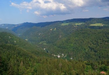
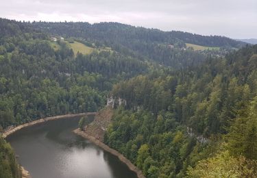
Ruta Otra actividad de 21 km a descubrir en Borgoña-Franco Condado, Doubs, Fournet-Blancheroche. Esta ruta ha sido propuesta por steve.
Descripción
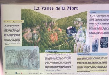
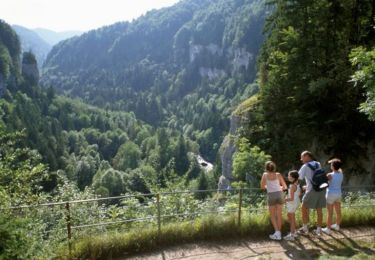
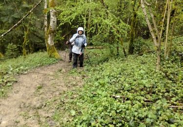
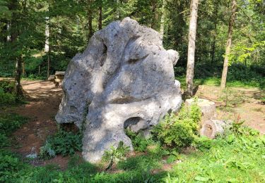
Magnifique rendonnée. A faire par temps beau. Prévoir de bonnes chaussures de marche, les sentiers sont parfois glissants. Sentier didactique sur les mémoires du Doubs. Difficultée facil mais endurant.
Localización
País:
France
Región :
Borgoña-Franco Condado
Departamento/provincia :
Doubs
Municipio :
Fournet-Blancheroche
Localidad:
Unknown
Salida:(Dec)
Salida:(UTM)
337648 ; 5225640 (32T) N.
Comentarios
Excursiones cerca
![Excursión Senderismo Charquemont - Échelles de la mort - Photo](https://media.geolcdn.com/t/375/260/7b9848bb-a43e-4c47-8544-5e7b63b496f6.jpg&format=jpg&maxdim=2)
![Senderismo Senderismo](https://static1.geolcdn.com/sitytour/trail-icons/101.png)
Échelles de la mort
Senderismo
Medio
(1)
Charquemont,
Borgoña-Franco Condado,
Doubs,
France
![](/images/other/stat-length.png)
6,5 km | 9,5 km-effort
1h 33min
![](https://static1.geolcdn.com/siteimages/upload/files/16400158638029165_repeat_loop_refresh_sync_direction_icon.png)
Sí
![Excursión Senderismo Charquemont - Les Echelles de la Mort - Doubs - Photo](https://media.geolcdn.com/t/375/260/ext.jpg?maxdim=2&url=https%3A%2F%2Fservices.sitytrail.com%2FGeolivesWS%2FDownloadMedia.ashx%3FTrailID%3D108929%26Media%3D2620_1.jpg)
![Senderismo Senderismo](https://static1.geolcdn.com/sitytour/trail-icons/101.png)
Les Echelles de la Mort - Doubs
Senderismo
Medio
(2)
Charquemont,
Borgoña-Franco Condado,
Doubs,
France
![](/images/other/stat-length.png)
8,4 km | 14,1 km-effort
3h 0min
![](https://static1.geolcdn.com/siteimages/upload/files/16400158638029165_repeat_loop_refresh_sync_direction_icon.png)
Sí
![Excursión Senderismo Fournet-Blancheroche - Combe de Biaufond - Photo](https://media.geolcdn.com/t/375/260/ext.jpg?maxdim=2&url=https%3A%2F%2Fstatic1.geolcdn.com%2Fsiteimages%2Fupload%2Ffiles%2F1553511878bg_sport_marche.png)
![Senderismo Senderismo](https://static1.geolcdn.com/sitytour/trail-icons/101.png)
Combe de Biaufond
Senderismo
Medio
(1)
Fournet-Blancheroche,
Borgoña-Franco Condado,
Doubs,
France
![](/images/other/stat-length.png)
11,7 km | 18,3 km-effort
4h 17min
![](https://static1.geolcdn.com/siteimages/upload/files/16400158638029165_repeat_loop_refresh_sync_direction_icon.png)
No
![Excursión sport Charquemont - Charquemont - Photo](https://media.geolcdn.com/t/375/260/2f6ea34c-c41e-4747-afa9-f8bc25b75ed3.jpg&format=jpg&maxdim=2)
Charquemont
sport
Muy fácil
Charquemont,
Borgoña-Franco Condado,
Doubs,
France
![](/images/other/stat-length.png)
5,5 km | 7,9 km-effort
Desconocido
![](https://static1.geolcdn.com/siteimages/upload/files/16400158638029165_repeat_loop_refresh_sync_direction_icon.png)
Sí
![Excursión Senderismo Charquemont - lçendre cha4quemond - Photo](https://media.geolcdn.com/t/375/260/d4b171d3-4707-4b81-9ad5-a84cf10f6378.jpg&format=jpg&maxdim=2)
![Senderismo Senderismo](https://static1.geolcdn.com/sitytour/trail-icons/101.png)
lçendre cha4quemond
Senderismo
Muy difícil
Charquemont,
Borgoña-Franco Condado,
Doubs,
France
![](/images/other/stat-length.png)
13,2 km | 22 km-effort
5h 55min
![](https://static1.geolcdn.com/siteimages/upload/files/16400158638029165_repeat_loop_refresh_sync_direction_icon.png)
Sí
![Excursión Senderismo Charquemont - Combes Saint Pierre - Photo](https://media.geolcdn.com/t/375/260/0b54ab85-de60-4572-870a-d1ef0de23798.jpg&format=jpg&maxdim=2)
![Senderismo Senderismo](https://static1.geolcdn.com/sitytour/trail-icons/101.png)
Combes Saint Pierre
Senderismo
Fácil
(1)
Charquemont,
Borgoña-Franco Condado,
Doubs,
France
![](/images/other/stat-length.png)
5,9 km | 8 km-effort
3h 29min
![](https://static1.geolcdn.com/siteimages/upload/files/16400158638029165_repeat_loop_refresh_sync_direction_icon.png)
Sí
![Excursión Senderismo Charquemont - Goumois-Le Boulois / Les échelles de la mort - Photo](https://media.geolcdn.com/t/375/260/e486823a-bed9-43a4-abeb-bf237649de07.jpg&format=jpg&maxdim=2)
![Senderismo Senderismo](https://static1.geolcdn.com/sitytour/trail-icons/101.png)
Goumois-Le Boulois / Les échelles de la mort
Senderismo
Medio
Charquemont,
Borgoña-Franco Condado,
Doubs,
France
![](/images/other/stat-length.png)
15,9 km | 26 km-effort
3h 14min
![](https://static1.geolcdn.com/siteimages/upload/files/16400158638029165_repeat_loop_refresh_sync_direction_icon.png)
Sí
![Excursión Senderismo Charquemont - LES ECHELLES DE LA MORT - Photo](https://media.geolcdn.com/t/375/260/eedace1f-3156-432d-a68f-d4e4629d6189.jpg&format=jpg&maxdim=2)
![Senderismo Senderismo](https://static1.geolcdn.com/sitytour/trail-icons/101.png)
LES ECHELLES DE LA MORT
Senderismo
Difícil
Charquemont,
Borgoña-Franco Condado,
Doubs,
France
![](/images/other/stat-length.png)
10,4 km | 17,1 km-effort
4h 42min
![](https://static1.geolcdn.com/siteimages/upload/files/16400158638029165_repeat_loop_refresh_sync_direction_icon.png)
Sí
![Excursión Bici de montaña Fournet-Blancheroche - j3 - Photo](https://media.geolcdn.com/t/375/260/3ef35ac2-9dde-466b-8bee-c8943e098f1e.jpg&format=jpg&maxdim=2)
![Bici de montaña Bici de montaña](https://static1.geolcdn.com/sitytour/trail-icons/202.png)
j3
Bici de montaña
Difícil
Fournet-Blancheroche,
Borgoña-Franco Condado,
Doubs,
France
![](/images/other/stat-length.png)
53 km | 69 km-effort
4h 50min
![](https://static1.geolcdn.com/siteimages/upload/files/16400158638029165_repeat_loop_refresh_sync_direction_icon.png)
No