![](/images/other/stat-length.png)
![Excursión A pie Saint-Paul - Boucle dans la Savane Saint Paul - Photo](https://media.geolcdn.com/t/1900/400/333c978c-1521-4106-aba8-01c6aacd64ee.jpg&format=pjpeg&maxdim=2)
Boucle dans la Savane Saint Paul
GilbertLP
Usuario
![Longitud](/images/other/stat-length.png)
![Altitud máxima](https://static1.geolcdn.com/siteimages/upload/files/1508320355ic_sort_altitude_max_24dp.png)
![Desnivel positivo](https://static1.geolcdn.com/siteimages/upload/files/1508320355ic_sort_den_pos_24dp.png)
![Km-Effort](/images/other/stat-length.png)
![Altitud mínima](https://static1.geolcdn.com/siteimages/upload/files/1508320355ic_sort_altitude_min_24dp.png)
![Desnivel negativo](https://static1.geolcdn.com/siteimages/upload/files/1508320355ic_sort_den_neg_24dp.png)
![Boucle](https://static1.geolcdn.com/siteimages/upload/files/16400158638029165_repeat_loop_refresh_sync_direction_icon.png)
![A pie](https://static1.geolcdn.com/sitytour/trail-icons/100.png)
--
Dificultad : Fácil
![Escanee este código QR para abrir la excursión en la aplicación SityTrail](https://capi.geolives.com/qq0zvz2zws4bq2lad0pu/sitytour/trails/2497578/qr.png?size=200)
Aplicación GPS de excursión GRATIS
A propósito
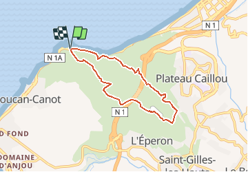
Ruta A pie de 8,4 km a descubrir en La Reunión, Desconocido, Saint-Paul. Esta ruta ha sido propuesta por GilbertLP.
Descripción
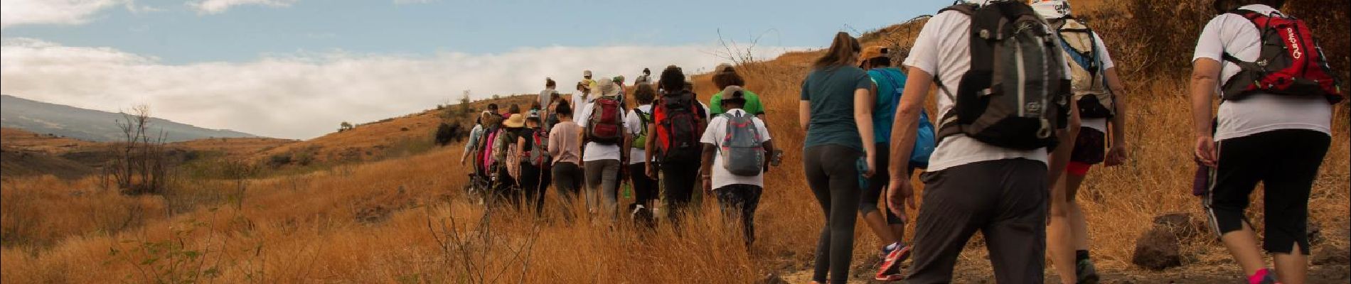
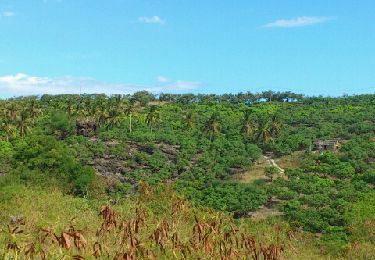
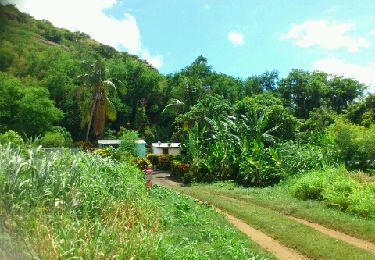
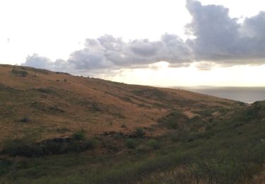
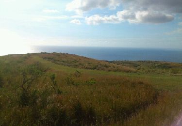
Cette petite randonnée entre le Cap Lahoussaye et Fleurimont, permet de se transporter dans une savane pittoresque aux couleurs fauves, laissant chacun imaginer qu'il se trouve quelque part en Afrique et qu'un lion pourrait surgir tout d'un coup derrière un rocher ! Mais pas de crainte à avoir concernant les animaux sauvages ; nous pourrions tout au plus rencontrer un lièvre, et encore.
Le parcours démarre au niveau du parking du Cap La Houssaye, juste après le tunnel de La Mariane en venant de Saint Paul. Il monte progressivement vers la Route des Tamarins qu'il croisera par en-dessous, en montée puis en descente. Tout en haut de la boucle, il emprunte sur 400 m environ le chemin Sumer, avant de replonger dans la savane.
D'une longueur de 8,5 km, avec un dénivelé positif de 260 m, cette randonnée est à la portée de tous marcheurs, petits et grands, et ne présente aucune difficulté technique.
Localización
Comentarios
Excursiones cerca
![Excursión Senderismo Saint-Paul - La Réunion - Boucle simple au départ de l'Hélilagon en passant par Cap La Houssaye - Photo](https://media.geolcdn.com/t/375/260/ext.jpg?maxdim=2&url=https%3A%2F%2Fservices.sitytrail.com%2FGeolivesWS%2FDownloadMedia.ashx%3FTrailID%3D272902%26Media%3Dfix__20140501135612.jpg)
![Senderismo Senderismo](https://static1.geolcdn.com/sitytour/trail-icons/101.png)
Senderismo
![](/images/other/stat-length.png)
![](https://static1.geolcdn.com/siteimages/upload/files/16400158638029165_repeat_loop_refresh_sync_direction_icon.png)
![Excursión Senderismo Saint-Paul - La Réunion - Ravine Bernica - Saint-Paul - Photo](https://media.geolcdn.com/t/375/260/ext.jpg?maxdim=2&url=https%3A%2F%2Fservices.sitytrail.com%2FGeolivesWS%2FDownloadMedia.ashx%3FTrailID%3D253595%26Media%3Dfix__20140302133911.jpg)
![Senderismo Senderismo](https://static1.geolcdn.com/sitytour/trail-icons/101.png)
Senderismo
![](/images/other/stat-length.png)
![](https://static1.geolcdn.com/siteimages/upload/files/16400158638029165_repeat_loop_refresh_sync_direction_icon.png)
![Excursión Senderismo Saint-Paul - Trois bassins - Photo](https://media.geolcdn.com/t/375/260/ext.jpg?maxdim=2&url=https%3A%2F%2Fstatic1.geolcdn.com%2Fsiteimages%2Fupload%2Ffiles%2F1553511878bg_sport_marche.png)
![Senderismo Senderismo](https://static1.geolcdn.com/sitytour/trail-icons/101.png)
Senderismo
![](/images/other/stat-length.png)
![](https://static1.geolcdn.com/siteimages/upload/files/16400158638029165_repeat_loop_refresh_sync_direction_icon.png)
![Excursión Senderismo Saint-Paul - Boucle Bassin bleu, via moulin Kader - Photo](https://media.geolcdn.com/t/375/260/ext.jpg?maxdim=2&url=https%3A%2F%2Fstatic1.geolcdn.com%2Fsiteimages%2Fupload%2Ffiles%2F1553511878bg_sport_marche.png)
![Senderismo Senderismo](https://static1.geolcdn.com/sitytour/trail-icons/101.png)
Senderismo
![](/images/other/stat-length.png)
![](https://static1.geolcdn.com/siteimages/upload/files/16400158638029165_repeat_loop_refresh_sync_direction_icon.png)
![Excursión A pie Saint-Paul - Boucle Moulin Kader - Photo](https://media.geolcdn.com/t/375/260/212dc708-94cd-4165-b5b8-470f7789e2ed.jpeg&format=jpg&maxdim=2)
![A pie A pie](https://static1.geolcdn.com/sitytour/trail-icons/100.png)
A pie
![](/images/other/stat-length.png)
![](https://static1.geolcdn.com/siteimages/upload/files/16400158638029165_repeat_loop_refresh_sync_direction_icon.png)
![Excursión Senderismo Saint-Paul - lacs des cormorans - Photo](https://media.geolcdn.com/t/375/260/4c25d3ec-4cc8-492f-901b-1443632724c9.jpg&format=jpg&maxdim=2)
![Senderismo Senderismo](https://static1.geolcdn.com/sitytour/trail-icons/101.png)
Senderismo
![](/images/other/stat-length.png)
![](https://static1.geolcdn.com/siteimages/upload/files/16400158638029165_repeat_loop_refresh_sync_direction_icon.png)
![Excursión Senderismo Saint-Paul - BAM1 - Photo](https://media.geolcdn.com/t/375/260/ext.jpg?maxdim=2&url=https%3A%2F%2Fservices.sitytrail.com%2FGeolivesWS%2FDownloadMedia.ashx%3FTrailID%3D774500%26Media%3D20170617175828.jpg)
![Senderismo Senderismo](https://static1.geolcdn.com/sitytour/trail-icons/101.png)
Senderismo
![](/images/other/stat-length.png)
![](https://static1.geolcdn.com/siteimages/upload/files/16400158638029165_repeat_loop_refresh_sync_direction_icon.png)
![Excursión Senderismo Saint-Paul - La Réunion - Boucle au départ de l'Hélilagon en passant par Cap La Houssaye - Photo](https://media.geolcdn.com/t/375/260/ext.jpg?maxdim=2&url=https%3A%2F%2Fservices.sitytrail.com%2FGeolivesWS%2FDownloadMedia.ashx%3FTrailID%3D285271%26Media%3Dfix__20140510153324.jpg)
![Senderismo Senderismo](https://static1.geolcdn.com/sitytour/trail-icons/101.png)
Senderismo
![](/images/other/stat-length.png)
![](https://static1.geolcdn.com/siteimages/upload/files/16400158638029165_repeat_loop_refresh_sync_direction_icon.png)
![Excursión Senderismo Saint-Paul - La Réunion - Boucle du moulin Kader, la cascade des Aigrettes et le Bassin Malheur - Photo](https://media.geolcdn.com/t/375/260/ext.jpg?maxdim=2&url=https%3A%2F%2Fservices.sitytrail.com%2FGeolivesWS%2FDownloadMedia.ashx%3FTrailID%3D270889%26Media%3Dfix__20140427120937.jpg)
![Senderismo Senderismo](https://static1.geolcdn.com/sitytour/trail-icons/101.png)
Senderismo
![](/images/other/stat-length.png)
![](https://static1.geolcdn.com/siteimages/upload/files/16400158638029165_repeat_loop_refresh_sync_direction_icon.png)