![](/images/other/stat-length.png)
![Excursión Senderismo Lescun - 64 Pic Anie - depuis Labérouat - Photo](https://media.geolcdn.com/t/1900/400/9d908d0f-919b-4794-a1ad-d7f2f5f8c8b8.jpg&format=pjpeg&maxdim=2)
64 Pic Anie - depuis Labérouat
Maryma
Usuario
![Longitud](/images/other/stat-length.png)
![Altitud máxima](https://static1.geolcdn.com/siteimages/upload/files/1508320355ic_sort_altitude_max_24dp.png)
![Desnivel positivo](https://static1.geolcdn.com/siteimages/upload/files/1508320355ic_sort_den_pos_24dp.png)
![Km-Effort](/images/other/stat-length.png)
![Altitud mínima](https://static1.geolcdn.com/siteimages/upload/files/1508320355ic_sort_altitude_min_24dp.png)
![Desnivel negativo](https://static1.geolcdn.com/siteimages/upload/files/1508320355ic_sort_den_neg_24dp.png)
![Boucle](https://static1.geolcdn.com/siteimages/upload/files/16400158638029165_repeat_loop_refresh_sync_direction_icon.png)
![Senderismo](https://static1.geolcdn.com/sitytour/trail-icons/101.png)
4h46
Dificultad : Difícil
![Escanee este código QR para abrir la excursión en la aplicación SityTrail](https://capi.geolives.com/qq0zvz2zws4bq2lad0pu/sitytour/trails/2493296/qr.png?size=200)
Aplicación GPS de excursión GRATIS
A propósito
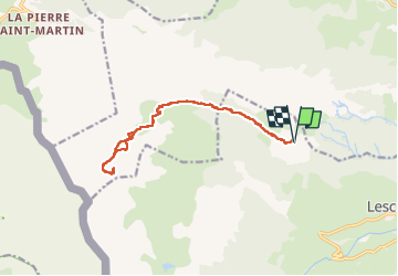
Ruta Senderismo de 15,6 km a descubrir en Nueva Aquitania, Pirineos-Atlánticos, Lescun. Esta ruta ha sido propuesta por Maryma.
Descripción
c'est un parcours exigeant en terme de dénivelé mais sans réelle difficulté même le passage de la cheminée pour lequel on met les mains.
Attention cependant à l'orientation après le lac d'Anie (à sec). On se perd vite sur les lapiaz.
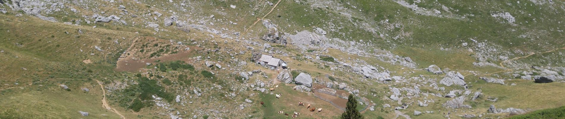
Vente de fromage aux cabanes de l'Ardinet et Cap de la Beitch le temps de l'estive! délicieux;-))
Localización
Comentarios
Excursiones cerca
![Excursión Senderismo Lescun - Le plateau de Sanchèse - Lescun - Photo](https://media.geolcdn.com/t/375/260/ext.jpg?maxdim=2&url=https%3A%2F%2Fservices.sitytrail.com%2FGeolivesWS%2FDownloadMedia.ashx%3FTrailID%3D111284%26Media%3D6928_1.jpg)
![Senderismo Senderismo](https://static1.geolcdn.com/sitytour/trail-icons/101.png)
Senderismo
![](/images/other/stat-length.png)
![](https://static1.geolcdn.com/siteimages/upload/files/16400158638029165_repeat_loop_refresh_sync_direction_icon.png)
![Excursión Senderismo Lescun - Lac de Lhurs - Photo](https://media.geolcdn.com/t/375/260/ext.jpg?maxdim=2&url=https%3A%2F%2Fservices.sitytrail.com%2FGeolivesWS%2FDownloadMedia.ashx%3FTrailID%3D106243%26Media%3D10574_1.jpg)
![Senderismo Senderismo](https://static1.geolcdn.com/sitytour/trail-icons/101.png)
Senderismo
![](/images/other/stat-length.png)
![](https://static1.geolcdn.com/siteimages/upload/files/16400158638029165_repeat_loop_refresh_sync_direction_icon.png)
![Excursión A pie Osse-en-Aspe - Tour panoramique Osse-Athas asp109 - Photo](https://media.geolcdn.com/t/375/260/fd742eea-9420-4aa3-9b7d-11c6f4a57c86.jpeg&format=jpg&maxdim=2)
![A pie A pie](https://static1.geolcdn.com/sitytour/trail-icons/100.png)
A pie
![](/images/other/stat-length.png)
![](https://static1.geolcdn.com/siteimages/upload/files/16400158638029165_repeat_loop_refresh_sync_direction_icon.png)
![Excursión A pie Lescun - Cabanes et Lac de Lhurs asp51 - Photo](https://media.geolcdn.com/t/375/260/6a266a45-7e80-4faa-8425-ef35e57a7e4a.jpeg&format=jpg&maxdim=2)
![A pie A pie](https://static1.geolcdn.com/sitytour/trail-icons/100.png)
A pie
![](/images/other/stat-length.png)
![](https://static1.geolcdn.com/siteimages/upload/files/16400158638029165_repeat_loop_refresh_sync_direction_icon.png)
![Excursión A pie Lées-Athas - Chemin d'Esquit à Lescun asp46 - Photo](https://media.geolcdn.com/t/375/260/f2e56414-5888-41b7-b503-d53feec7e149.jpeg&format=jpg&maxdim=2)
![A pie A pie](https://static1.geolcdn.com/sitytour/trail-icons/100.png)
A pie
![](/images/other/stat-length.png)
![](https://static1.geolcdn.com/siteimages/upload/files/16400158638029165_repeat_loop_refresh_sync_direction_icon.png)
![Excursión A pie Lescun - Tour du Belvédère asp47 - Photo](https://media.geolcdn.com/t/375/260/3d73b6d7-975c-44ff-8d63-4ea540b69f0c.jpeg&format=jpg&maxdim=2)
![A pie A pie](https://static1.geolcdn.com/sitytour/trail-icons/100.png)
A pie
![](/images/other/stat-length.png)
![](https://static1.geolcdn.com/siteimages/upload/files/16400158638029165_repeat_loop_refresh_sync_direction_icon.png)
![Excursión A pie Lées-Athas - Tour du Vallon asp11 - Photo](https://media.geolcdn.com/t/375/260/2a9d4696-f777-4a16-902f-6373154f4697.jpeg&format=jpg&maxdim=2)
![A pie A pie](https://static1.geolcdn.com/sitytour/trail-icons/100.png)
A pie
![](/images/other/stat-length.png)
![](https://static1.geolcdn.com/siteimages/upload/files/16400158638029165_repeat_loop_refresh_sync_direction_icon.png)
![Excursión A pie Lescun - Refuge de Linza par le Col de Pétragème asp119 - Photo](https://media.geolcdn.com/t/375/260/96f1c4ac-fbcc-4ef8-930f-02b32609dc3b.jpeg&format=jpg&maxdim=2)
![A pie A pie](https://static1.geolcdn.com/sitytour/trail-icons/100.png)
A pie
![](/images/other/stat-length.png)
![](https://static1.geolcdn.com/siteimages/upload/files/16400158638029165_repeat_loop_refresh_sync_direction_icon.png)
![Excursión Senderismo Lescun - Cirque de Lescun - Photo](https://media.geolcdn.com/t/375/260/d435ee66-b9e1-4e5f-a628-c21e49952bda.jpg&format=jpg&maxdim=2)
![Senderismo Senderismo](https://static1.geolcdn.com/sitytour/trail-icons/101.png)
Senderismo
![](/images/other/stat-length.png)
![](https://static1.geolcdn.com/siteimages/upload/files/16400158638029165_repeat_loop_refresh_sync_direction_icon.png)