![](/images/other/stat-length.png)
![Excursión Bici de montaña Anniviers - WallisBike 06 Hotel Weisshorn - Visperterminen - Photo](https://media.geolcdn.com/t/1900/400/ext.pjpeg?maxdim=2&url=https%3A%2F%2Fstatic1.geolcdn.com%2Fsiteimages%2Fupload%2Ffiles%2F1524743154velo.jpg)
WallisBike 06 Hotel Weisshorn - Visperterminen
ovronne
Usuario
![Longitud](/images/other/stat-length.png)
Longitud
51 km
![Altitud máxima](https://static1.geolcdn.com/siteimages/upload/files/1508320355ic_sort_altitude_max_24dp.png)
Altitud máxima
2888 m
![Desnivel positivo](https://static1.geolcdn.com/siteimages/upload/files/1508320355ic_sort_den_pos_24dp.png)
Desnivel positivo
2614 m
![Km-Effort](/images/other/stat-length.png)
Km-Effort
89 km
![Altitud mínima](https://static1.geolcdn.com/siteimages/upload/files/1508320355ic_sort_altitude_min_24dp.png)
Altitud mínima
737 m
![Desnivel negativo](https://static1.geolcdn.com/siteimages/upload/files/1508320355ic_sort_den_neg_24dp.png)
Desnivel negativo
3580 m
![Boucle](https://static1.geolcdn.com/siteimages/upload/files/16400158638029165_repeat_loop_refresh_sync_direction_icon.png)
Boucle
No
Fecha de creación :
2014-12-11 00:00:00.0
Última modificación :
2014-12-11 00:00:00.0
![Bici de montaña](https://static1.geolcdn.com/sitytour/trail-icons/202.png)
8h40
Dificultad : Desconocido
![Escanee este código QR para abrir la excursión en la aplicación SityTrail](https://capi.geolives.com/qq0zvz2zws4bq2lad0pu/sitytour/trails/24931/qr.png?size=200)
Aplicación GPS de excursión GRATIS
A propósito
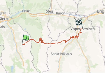
Ruta Bici de montaña de 51 km a descubrir en Vallés, Sierre, Anniviers. Esta ruta ha sido propuesta por ovronne.
Descripción
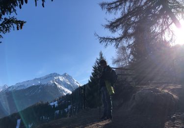
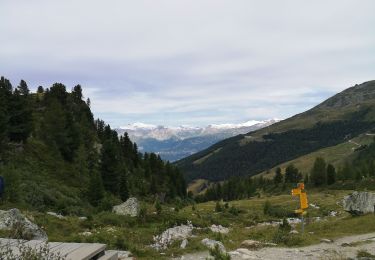
Sixième étape de la traversée des Alpes Suisse de St-Gingolph à Scuol.
Départ de l''Hôtel Weisshorn, montée jusqu''au Meidpass. Descente sur Gruben.
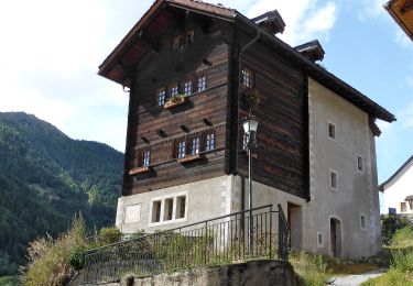
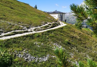
Montée jusqu''au Augstbordpass. Descente sur Embd, direction Stalden et montée jusqu''à Visperterminen.
Localización
País:
Switzerland
Región :
Vallés
Departamento/provincia :
Sierre
Municipio :
Anniviers
Localidad:
Unknown
Salida:(Dec)
Salida:(UTM)
393371 ; 5118115 (32T) N.
Comentarios
Excursiones cerca
![Excursión Senderismo Anniviers - St Luc Bella Tolla lacs - circuit - Photo](https://media.geolcdn.com/t/375/260/ext.jpg?maxdim=2&url=https%3A%2F%2Fservices.sitytrail.com%2FGeolivesWS%2FDownloadMedia.ashx%3FTrailID%3D800602%26Media%3Dfix__20170801152946.jpg)
![Senderismo Senderismo](https://static1.geolcdn.com/sitytour/trail-icons/101.png)
St Luc Bella Tolla lacs - circuit
Senderismo
Fácil
(1)
Anniviers,
Vallés,
Sierre,
Switzerland
![](/images/other/stat-length.png)
11,5 km | 19,5 km-effort
3h 45min
![](https://static1.geolcdn.com/siteimages/upload/files/16400158638029165_repeat_loop_refresh_sync_direction_icon.png)
No
![Excursión A pie Anniviers - Chandolin-St Luc - Photo](https://media.geolcdn.com/t/375/260/b633d733-26b1-43a9-9ad5-754a77828ddc.jpeg&format=jpg&maxdim=2)
![A pie A pie](https://static1.geolcdn.com/sitytour/trail-icons/100.png)
Chandolin-St Luc
A pie
Fácil
Anniviers,
Vallés,
Sierre,
Switzerland
![](/images/other/stat-length.png)
4,9 km | 7,4 km-effort
1h 40min
![](https://static1.geolcdn.com/siteimages/upload/files/16400158638029165_repeat_loop_refresh_sync_direction_icon.png)
No
![Excursión A pie Anniviers - Hôtel Weisshorn-Zinal - Photo](https://media.geolcdn.com/t/375/260/c8a70107-c0c4-41f1-8be0-f57ff0488907.jpeg&format=jpg&maxdim=2)
![A pie A pie](https://static1.geolcdn.com/sitytour/trail-icons/100.png)
Hôtel Weisshorn-Zinal
A pie
Fácil
Anniviers,
Vallés,
Sierre,
Switzerland
![](/images/other/stat-length.png)
11,3 km | 15,5 km-effort
3h 31min
![](https://static1.geolcdn.com/siteimages/upload/files/16400158638029165_repeat_loop_refresh_sync_direction_icon.png)
No
![Senderismo Senderismo](https://static1.geolcdn.com/sitytour/trail-icons/101.png)
Grimentz Parcours de la Montagnetta (PVDB)
Senderismo
Difícil
Anniviers,
Vallés,
Sierre,
Switzerland
![](/images/other/stat-length.png)
10,1 km | 17,1 km-effort
3h 53min
![](https://static1.geolcdn.com/siteimages/upload/files/16400158638029165_repeat_loop_refresh_sync_direction_icon.png)
Sí
![Excursión A pie Anniviers - Grand Bisse de St-Jean - Photo](https://media.geolcdn.com/t/375/260/79f0d4de-a338-4f1b-99e4-2ce99fd58942.jpeg&format=jpg&maxdim=2)
![A pie A pie](https://static1.geolcdn.com/sitytour/trail-icons/100.png)
Grand Bisse de St-Jean
A pie
Fácil
Anniviers,
Vallés,
Sierre,
Switzerland
![](/images/other/stat-length.png)
5 km | 8,4 km-effort
1h 54min
![](https://static1.geolcdn.com/siteimages/upload/files/16400158638029165_repeat_loop_refresh_sync_direction_icon.png)
No
![Excursión Senderismo Anniviers - Weisshorn - Photo](https://media.geolcdn.com/t/375/260/d27c003d-15e9-481f-9404-a1de66cc28ce.jpg&format=jpg&maxdim=2)
![Senderismo Senderismo](https://static1.geolcdn.com/sitytour/trail-icons/101.png)
Weisshorn
Senderismo
Medio
Anniviers,
Vallés,
Sierre,
Switzerland
![](/images/other/stat-length.png)
4,8 km | 7,4 km-effort
2h 23min
![](https://static1.geolcdn.com/siteimages/upload/files/16400158638029165_repeat_loop_refresh_sync_direction_icon.png)
No
![Excursión Senderismo Anniviers - weisshorn - Photo](https://media.geolcdn.com/t/375/260/a1880e41-8f34-480e-9f04-d315e98e0e91.jpg&format=jpg&maxdim=2)
![Senderismo Senderismo](https://static1.geolcdn.com/sitytour/trail-icons/101.png)
weisshorn
Senderismo
Medio
(1)
Anniviers,
Vallés,
Sierre,
Switzerland
![](/images/other/stat-length.png)
4,7 km | 7,4 km-effort
1h 43min
![](https://static1.geolcdn.com/siteimages/upload/files/16400158638029165_repeat_loop_refresh_sync_direction_icon.png)
No
![Excursión Marcha nórdica Anniviers - Weisshorn - Photo](https://media.geolcdn.com/t/375/260/b5a96cd2-adda-41b3-9a3f-91eb23c2378a.jpg&format=jpg&maxdim=2)
![Marcha nórdica Marcha nórdica](https://static1.geolcdn.com/sitytour/trail-icons/102.png)
Weisshorn
Marcha nórdica
Muy fácil
Anniviers,
Vallés,
Sierre,
Switzerland
![](/images/other/stat-length.png)
14,2 km | 21 km-effort
4h 36min
![](https://static1.geolcdn.com/siteimages/upload/files/16400158638029165_repeat_loop_refresh_sync_direction_icon.png)
No
![Excursión A pie Anniviers - Tignousa-Le Tsapé - Photo](https://media.geolcdn.com/t/375/260/ext.jpg?maxdim=2&url=https%3A%2F%2Fstatic1.geolcdn.com%2Fsiteimages%2Fupload%2Ffiles%2F1545311037marcheuse_200dpi.jpg)
![A pie A pie](https://static1.geolcdn.com/sitytour/trail-icons/100.png)
Tignousa-Le Tsapé
A pie
Fácil
Anniviers,
Vallés,
Sierre,
Switzerland
![](/images/other/stat-length.png)
3,8 km | 7,7 km-effort
1h 45min
![](https://static1.geolcdn.com/siteimages/upload/files/16400158638029165_repeat_loop_refresh_sync_direction_icon.png)
No