![](/images/other/stat-length.png)
![Excursión Senderismo Arrens-Marsous - pic de cristayet - Photo](https://media.geolcdn.com/t/1900/400/4c1e26d5-197f-441e-9709-6adb4628c945.jpg&format=pjpeg&maxdim=2)
pic de cristayet
PVERTICAL
Usuario
![Longitud](/images/other/stat-length.png)
![Altitud máxima](https://static1.geolcdn.com/siteimages/upload/files/1508320355ic_sort_altitude_max_24dp.png)
![Desnivel positivo](https://static1.geolcdn.com/siteimages/upload/files/1508320355ic_sort_den_pos_24dp.png)
![Km-Effort](/images/other/stat-length.png)
![Altitud mínima](https://static1.geolcdn.com/siteimages/upload/files/1508320355ic_sort_altitude_min_24dp.png)
![Desnivel negativo](https://static1.geolcdn.com/siteimages/upload/files/1508320355ic_sort_den_neg_24dp.png)
![Boucle](https://static1.geolcdn.com/siteimages/upload/files/16400158638029165_repeat_loop_refresh_sync_direction_icon.png)
![Senderismo](https://static1.geolcdn.com/sitytour/trail-icons/101.png)
9h32
Dificultad : Difícil
![Escanee este código QR para abrir la excursión en la aplicación SityTrail](https://capi.geolives.com/qq0zvz2zws4bq2lad0pu/sitytour/trails/2482579/qr.png?size=200)
Aplicación GPS de excursión GRATIS
A propósito
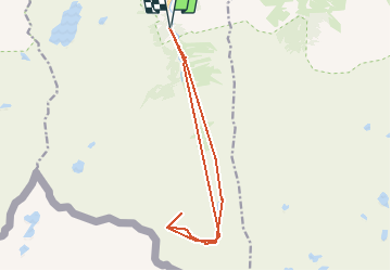
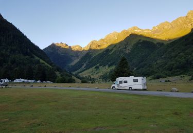
Ruta Senderismo de 15,7 km a descubrir en Occitania, Altos-Pirineos, Arrens-Marsous. Esta ruta ha sido propuesta por PVERTICAL.
Descripción
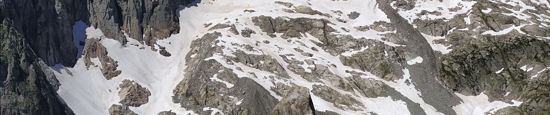
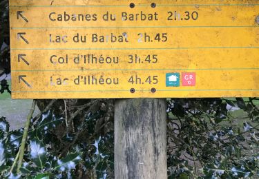
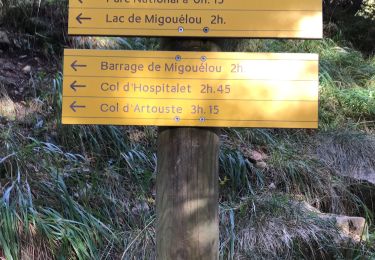
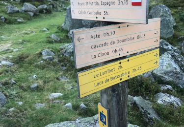
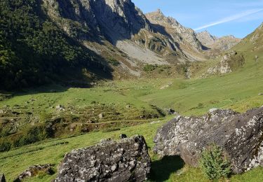
Depuis la maison du Parc au Plaa d'Aste. Suivre le sentier en direction du port Peyre St Martin. Au dessus des lacs de Remoulis, un cairn vous indique de descendre en pente douce vers la rivière et la Toue de Casterie. Traverser la rivière puis remonter la pente en suivant quelques cairns jusqu'à la brèche de Las Neous. Suivre la crête en contrebas (quelques cairns et traces) jusqu'à l'aplomb du sommet que l'on rejoint sans difficulté (pas de cheminées) . Il faut mettre les mains pour l'ascension finale et la descente pour s'équilibrer. (Attention néanmoins aux pentes herbeuses en cas de pluies, glissade...) Depuis le sommet, magnifique panorama en 360 °, notamment Balaitous et glacier de las Neous etc.... Point d'eau dans la montée/descente de la brèche.
Localización
Comentarios
Excursiones cerca
![Excursión Senderismo Estaing - ESTAING RS le der de 2022 - Photo](https://media.geolcdn.com/t/375/260/0404f897-2945-4225-b4b6-dbaf65ce5d84.jpg&format=jpg&maxdim=2)
![Senderismo Senderismo](https://static1.geolcdn.com/sitytour/trail-icons/101.png)
Senderismo
![](/images/other/stat-length.png)
![](https://static1.geolcdn.com/siteimages/upload/files/16400158638029165_repeat_loop_refresh_sync_direction_icon.png)
![Excursión Senderismo Estaing - Ruines et lac de Liantran - Photo](https://media.geolcdn.com/t/375/260/1b91bce4-1111-454c-9093-1e2ab24d6024.jpg&format=jpg&maxdim=2)
![Senderismo Senderismo](https://static1.geolcdn.com/sitytour/trail-icons/101.png)
Senderismo
![](/images/other/stat-length.png)
![](https://static1.geolcdn.com/siteimages/upload/files/16400158638029165_repeat_loop_refresh_sync_direction_icon.png)
![Excursión Senderismo Estaing - Pyrénées jour 4 - Photo](https://media.geolcdn.com/t/375/260/5c6b756a-151d-456f-a813-d2eed350fb7d.jpg&format=jpg&maxdim=2)
![Senderismo Senderismo](https://static1.geolcdn.com/sitytour/trail-icons/101.png)
Senderismo
![](/images/other/stat-length.png)
![](https://static1.geolcdn.com/siteimages/upload/files/16400158638029165_repeat_loop_refresh_sync_direction_icon.png)
![Excursión Senderismo Arrens-Marsous - Pyrénées jour 3 - Photo](https://media.geolcdn.com/t/375/260/f0337aed-7c8f-4a4e-8cd6-fd5a1a5be425.jpg&format=jpg&maxdim=2)
![Senderismo Senderismo](https://static1.geolcdn.com/sitytour/trail-icons/101.png)
Senderismo
![](/images/other/stat-length.png)
![](https://static1.geolcdn.com/siteimages/upload/files/16400158638029165_repeat_loop_refresh_sync_direction_icon.png)
![Excursión Senderismo Arrens-Marsous - Pyrénées jour 2 - Photo](https://media.geolcdn.com/t/375/260/47560504-9532-4271-bcaa-9f510a9d197b.jpg&format=jpg&maxdim=2)
![Senderismo Senderismo](https://static1.geolcdn.com/sitytour/trail-icons/101.png)
Senderismo
![](/images/other/stat-length.png)
![](https://static1.geolcdn.com/siteimages/upload/files/16400158638029165_repeat_loop_refresh_sync_direction_icon.png)
![Excursión Senderismo Arrens-Marsous - Tech - Ausseila. - Photo](https://media.geolcdn.com/t/375/260/12428191-124f-4fd1-ab66-0d522905b93b.jpg&format=jpg&maxdim=2)
![Senderismo Senderismo](https://static1.geolcdn.com/sitytour/trail-icons/101.png)
Senderismo
![](/images/other/stat-length.png)
![](https://static1.geolcdn.com/siteimages/upload/files/16400158638029165_repeat_loop_refresh_sync_direction_icon.png)
![Excursión Senderismo Arrens-Marsous - Refuge de LARRIBET - Photo](https://media.geolcdn.com/t/375/260/a45753d2-1ce8-41ec-9fa9-20d3b65809a7.jpg&format=jpg&maxdim=2)
![Senderismo Senderismo](https://static1.geolcdn.com/sitytour/trail-icons/101.png)
Senderismo
![](/images/other/stat-length.png)
![](https://static1.geolcdn.com/siteimages/upload/files/16400158638029165_repeat_loop_refresh_sync_direction_icon.png)
![Excursión Senderismo Estaing - Circulaire lac Estaing par brèche de Hourat - Photo](https://media.geolcdn.com/t/375/260/26209189-3d34-4e85-887a-a4af7697d195.jpg&format=jpg&maxdim=2)
![Senderismo Senderismo](https://static1.geolcdn.com/sitytour/trail-icons/101.png)
Senderismo
![](/images/other/stat-length.png)
![](https://static1.geolcdn.com/siteimages/upload/files/16400158638029165_repeat_loop_refresh_sync_direction_icon.png)
![Excursión Senderismo Estaing - 190514-Lac Estaing/Lac du Plat de Praat - Photo](https://media.geolcdn.com/t/375/260/caad8fe0-8965-4e2e-962b-f29bbb3025a0.jpg&format=jpg&maxdim=2)
![Senderismo Senderismo](https://static1.geolcdn.com/sitytour/trail-icons/101.png)
Senderismo
![](/images/other/stat-length.png)
![](https://static1.geolcdn.com/siteimages/upload/files/16400158638029165_repeat_loop_refresh_sync_direction_icon.png)