![](/images/other/stat-length.png)
vattetot sur mer -vaucotte- étigue
doboul
Usuario
![Longitud](/images/other/stat-length.png)
Longitud
8,1 km
![Altitud máxima](https://static1.geolcdn.com/siteimages/upload/files/1508320355ic_sort_altitude_max_24dp.png)
Altitud máxima
93 m
![Desnivel positivo](https://static1.geolcdn.com/siteimages/upload/files/1508320355ic_sort_den_pos_24dp.png)
Desnivel positivo
177 m
![Km-Effort](/images/other/stat-length.png)
Km-Effort
10,5 km
![Altitud mínima](https://static1.geolcdn.com/siteimages/upload/files/1508320355ic_sort_altitude_min_24dp.png)
Altitud mínima
8 m
![Desnivel negativo](https://static1.geolcdn.com/siteimages/upload/files/1508320355ic_sort_den_neg_24dp.png)
Desnivel negativo
177 m
![Boucle](https://static1.geolcdn.com/siteimages/upload/files/16400158638029165_repeat_loop_refresh_sync_direction_icon.png)
Boucle
Sí
Fecha de creación :
2020-07-19 14:05:11.127
Última modificación :
2020-07-19 14:12:22.248
![A pie](https://static1.geolcdn.com/sitytour/trail-icons/100.png)
--
Dificultad : Medio
![Escanee este código QR para abrir la excursión en la aplicación SityTrail](https://capi.geolives.com/qq0zvz2zws4bq2lad0pu/sitytour/trails/2482071/qr.png?size=200)
Aplicación GPS de excursión GRATIS
A propósito
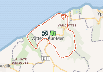
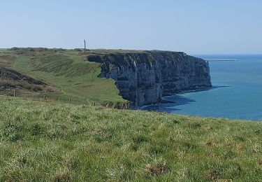
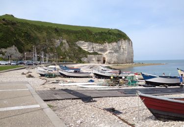
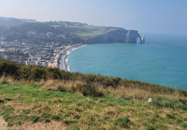
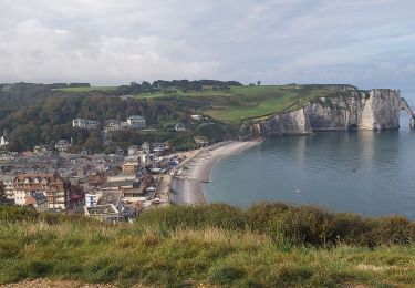
Ruta A pie de 8,1 km a descubrir en Normandía, Sena-Marítimo, Vattetot-sur-Mer. Esta ruta ha sido propuesta por doboul.
Descripción
8km possibilité de rallonger dans bois des hogues
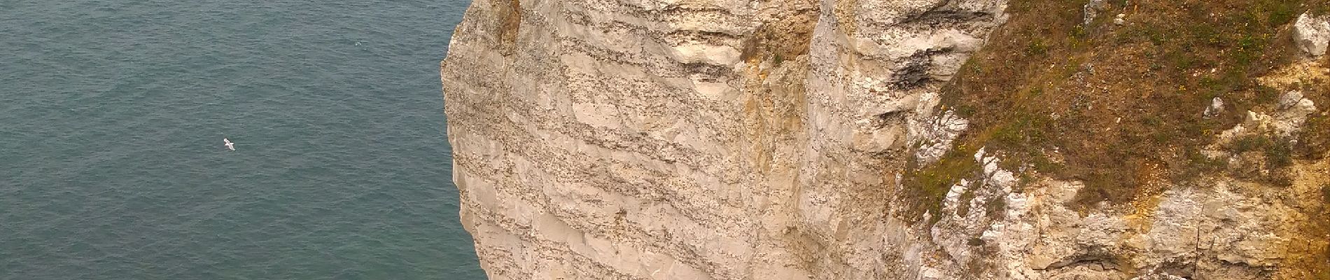
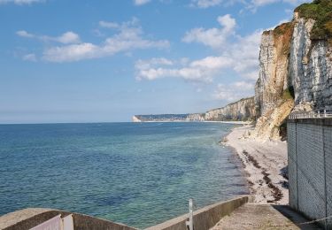
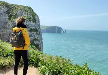
plus jolie a finir par les falaises vu sur etretat ( attention aux descentes herbeuses)
Localización
País:
France
Región :
Normandía
Departamento/provincia :
Sena-Marítimo
Municipio :
Vattetot-sur-Mer
Localidad:
Unknown
Salida:(Dec)
Salida:(UTM)
304051 ; 5511908 (31U) N.
Comentarios
Excursiones cerca
![Excursión Senderismo Vattetot-sur-Mer - vattetot - yport - Photo](https://media.geolcdn.com/t/375/260/66be9f19-29f6-4699-afaa-43c281fab658.jpg&format=jpg&maxdim=2)
![Senderismo Senderismo](https://static1.geolcdn.com/sitytour/trail-icons/101.png)
vattetot - yport
Senderismo
Medio
Vattetot-sur-Mer,
Normandía,
Sena-Marítimo,
France
![](/images/other/stat-length.png)
10,3 km | 13,2 km-effort
2h 29min
![](https://static1.geolcdn.com/siteimages/upload/files/16400158638029165_repeat_loop_refresh_sync_direction_icon.png)
Sí
![Excursión Senderismo Bénouville - L'aiguille de Belval - Photo](https://media.geolcdn.com/t/375/260/e5015acf-207d-4f0a-9245-b6a712853198.jpg&format=jpg&maxdim=2)
![Senderismo Senderismo](https://static1.geolcdn.com/sitytour/trail-icons/101.png)
L'aiguille de Belval
Senderismo
Medio
Bénouville,
Normandía,
Sena-Marítimo,
France
![](/images/other/stat-length.png)
9 km | 11,1 km-effort
2h 31min
![](https://static1.geolcdn.com/siteimages/upload/files/16400158638029165_repeat_loop_refresh_sync_direction_icon.png)
Sí
![Excursión Senderismo Étretat - Falaise d'Etretat - Photo](https://media.geolcdn.com/t/375/260/f69257bf-8597-4797-8e18-5f418d814afc.jpg&format=jpg&maxdim=2)
![Senderismo Senderismo](https://static1.geolcdn.com/sitytour/trail-icons/101.png)
Falaise d'Etretat
Senderismo
Fácil
Étretat,
Normandía,
Sena-Marítimo,
France
![](/images/other/stat-length.png)
9 km | 11,8 km-effort
2h 19min
![](https://static1.geolcdn.com/siteimages/upload/files/16400158638029165_repeat_loop_refresh_sync_direction_icon.png)
Sí
![Excursión Senderismo Bénouville - Benouville etretat - Photo](https://media.geolcdn.com/t/375/260/543eccce-24de-4ed3-90c1-133bb33b206c.jpg&format=jpg&maxdim=2)
![Senderismo Senderismo](https://static1.geolcdn.com/sitytour/trail-icons/101.png)
Benouville etretat
Senderismo
Fácil
Bénouville,
Normandía,
Sena-Marítimo,
France
![](/images/other/stat-length.png)
4,4 km | 5 km-effort
1h 9min
![](https://static1.geolcdn.com/siteimages/upload/files/16400158638029165_repeat_loop_refresh_sync_direction_icon.png)
No
![Excursión Senderismo Yport - Yport - Benouvile par le chemin des falaises - Photo](https://media.geolcdn.com/t/375/260/82151ad4-1a38-41f7-8b59-7954f319f077.jpg&format=jpg&maxdim=2)
![Senderismo Senderismo](https://static1.geolcdn.com/sitytour/trail-icons/101.png)
Yport - Benouvile par le chemin des falaises
Senderismo
Medio
Yport,
Normandía,
Sena-Marítimo,
France
![](/images/other/stat-length.png)
13,5 km | 18,5 km-effort
3h 25min
![](https://static1.geolcdn.com/siteimages/upload/files/16400158638029165_repeat_loop_refresh_sync_direction_icon.png)
Sí
![Excursión Senderismo Bénouville - Les Falaises d' Etretat depuis Bénouville - Photo](https://media.geolcdn.com/t/375/260/ae9173a3-fce5-4636-a6f0-47aefde118f4.jpg&format=jpg&maxdim=2)
![Senderismo Senderismo](https://static1.geolcdn.com/sitytour/trail-icons/101.png)
Les Falaises d' Etretat depuis Bénouville
Senderismo
Fácil
Bénouville,
Normandía,
Sena-Marítimo,
France
![](/images/other/stat-length.png)
9,1 km | 10,5 km-effort
2h 15min
![](https://static1.geolcdn.com/siteimages/upload/files/16400158638029165_repeat_loop_refresh_sync_direction_icon.png)
Sí
![Excursión Senderismo Yport - autour d'yport - Photo](https://media.geolcdn.com/t/375/260/ext.jpg?maxdim=2&url=https%3A%2F%2Fservices.sitytrail.com%2FGeolivesWS%2FDownloadMedia.ashx%3FTrailID%3D273700%26Media%3D20140504124244.jpg)
![Senderismo Senderismo](https://static1.geolcdn.com/sitytour/trail-icons/101.png)
autour d'yport
Senderismo
Medio
Yport,
Normandía,
Sena-Marítimo,
France
![](/images/other/stat-length.png)
15 km | 19,3 km-effort
4h 7min
![](https://static1.geolcdn.com/siteimages/upload/files/16400158638029165_repeat_loop_refresh_sync_direction_icon.png)
Sí
![Excursión Senderismo Bénouville - Bénouville -Etretat par les falaises - Photo](https://media.geolcdn.com/t/375/260/37f8ded3-518c-47ca-9c35-d0592e2177a6.jpg&format=jpg&maxdim=2)
![Senderismo Senderismo](https://static1.geolcdn.com/sitytour/trail-icons/101.png)
Bénouville -Etretat par les falaises
Senderismo
Medio
Bénouville,
Normandía,
Sena-Marítimo,
France
![](/images/other/stat-length.png)
8,1 km | 9,2 km-effort
3h 14min
![](https://static1.geolcdn.com/siteimages/upload/files/16400158638029165_repeat_loop_refresh_sync_direction_icon.png)
Sí
![Excursión Marcha nórdica Bénouville - Benouville - Photo](https://media.geolcdn.com/t/375/260/4b4c8295-5085-4473-87db-61a95d362b32.jpg&format=jpg&maxdim=2)
![Marcha nórdica Marcha nórdica](https://static1.geolcdn.com/sitytour/trail-icons/102.png)
Benouville
Marcha nórdica
Fácil
Bénouville,
Normandía,
Sena-Marítimo,
France
![](/images/other/stat-length.png)
9,7 km | 12,8 km-effort
2h 42min
![](https://static1.geolcdn.com/siteimages/upload/files/16400158638029165_repeat_loop_refresh_sync_direction_icon.png)
Sí