![](/images/other/stat-length.png)
![Excursión Senderismo Clavans-en-Haut-Oisans - lac des Quirlies - Photo](https://media.geolcdn.com/t/1900/400/0d4dea6f-675c-42f0-9703-71d1bbdff129.jpg&format=pjpeg&maxdim=2)
lac des Quirlies
GuyVachet
Usuario
![Longitud](/images/other/stat-length.png)
![Altitud máxima](https://static1.geolcdn.com/siteimages/upload/files/1508320355ic_sort_altitude_max_24dp.png)
![Desnivel positivo](https://static1.geolcdn.com/siteimages/upload/files/1508320355ic_sort_den_pos_24dp.png)
![Km-Effort](/images/other/stat-length.png)
![Altitud mínima](https://static1.geolcdn.com/siteimages/upload/files/1508320355ic_sort_altitude_min_24dp.png)
![Desnivel negativo](https://static1.geolcdn.com/siteimages/upload/files/1508320355ic_sort_den_neg_24dp.png)
![Boucle](https://static1.geolcdn.com/siteimages/upload/files/16400158638029165_repeat_loop_refresh_sync_direction_icon.png)
![Senderismo](https://static1.geolcdn.com/sitytour/trail-icons/101.png)
7h30
Dificultad : Difícil
![Escanee este código QR para abrir la excursión en la aplicación SityTrail](https://capi.geolives.com/qq0zvz2zws4bq2lad0pu/sitytour/trails/2476182/qr.png?size=200)
Aplicación GPS de excursión GRATIS
A propósito
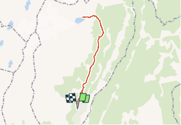
Ruta Senderismo de 15 km a descubrir en Auvergne-Rhône-Alpes, Isère, Clavans-en-Haut-Oisans. Esta ruta ha sido propuesta por GuyVachet.
Descripción
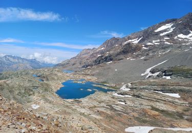
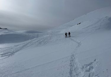
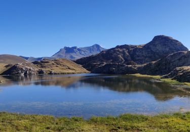
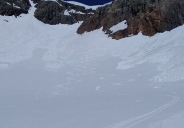
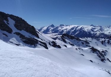
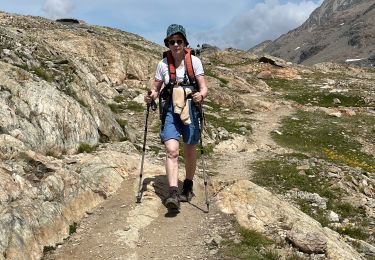
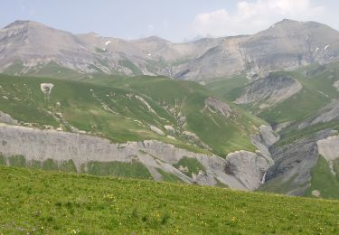
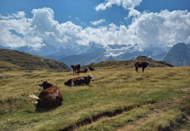
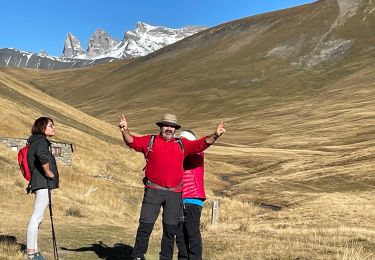
Montée au lac des Quirlies pour découvrir une très belle atmosphère de montagne au pied des pics Bayle et de l'Etendard. Le départ se fait à partir du hameau du Perron pour passer au Pont Ferrand qui est dominé par deux magnifiques cascades (photo). L'itinéraire remonte le cours du Ferrant qui est une tourbière (voir panneau explicatif) et monte tranquillement jusqu'à la passerelle. La montée devient alors soutenue pour traverser de petits névés à 2450m encore présents à la mi-Juillet avant d'arriver au lac 100m plus haut. Le retour se fait par le même itinéraire et permet de redécouvrir la mythique Meije.
Localización
Comentarios
Excursiones cerca
![Excursión Senderismo Huez - circuit des lacs, Blanc, du milieu, de la Fare, Balme rousse,dôme des Rousses - Photo](https://media.geolcdn.com/t/375/260/c258a7a0-21e3-440d-bfc0-b7f2c4802255.jpg&format=jpg&maxdim=2)
![Senderismo Senderismo](https://static1.geolcdn.com/sitytour/trail-icons/101.png)
Senderismo
![](/images/other/stat-length.png)
![](https://static1.geolcdn.com/siteimages/upload/files/16400158638029165_repeat_loop_refresh_sync_direction_icon.png)
![Excursión Raquetas de nieve Oz - 2800 m lacs du Milieu de la Fare et Balme rousse AR - Photo](https://media.geolcdn.com/t/375/260/9360f6ea-b2a0-45d2-a0dd-828425529dab.jpg&format=jpg&maxdim=2)
![Raquetas de nieve Raquetas de nieve](https://static1.geolcdn.com/sitytour/trail-icons/504.png)
Raquetas de nieve
![](/images/other/stat-length.png)
![](https://static1.geolcdn.com/siteimages/upload/files/16400158638029165_repeat_loop_refresh_sync_direction_icon.png)
![Excursión Senderismo Mizoën - 2020-09-05 Marche Refuge Fay Plateau Emparis La Grave - Photo](https://media.geolcdn.com/t/375/260/fad0353c-ad9c-4623-b445-e391df98cbf1.jpg&format=jpg&maxdim=2)
![Senderismo Senderismo](https://static1.geolcdn.com/sitytour/trail-icons/101.png)
Senderismo
![](/images/other/stat-length.png)
![](https://static1.geolcdn.com/siteimages/upload/files/16400158638029165_repeat_loop_refresh_sync_direction_icon.png)
![Excursión Esquí de fondo Clavans-en-Haut-Oisans - col du milieu au départ du col de Sarenne - Photo](https://media.geolcdn.com/t/375/260/f27aadb4-937b-481a-8166-c706d88b2606.jpg&format=jpg&maxdim=2)
![Esquí de fondo Esquí de fondo](https://static1.geolcdn.com/sitytour/trail-icons/503.png)
Esquí de fondo
![](/images/other/stat-length.png)
![](https://static1.geolcdn.com/siteimages/upload/files/16400158638029165_repeat_loop_refresh_sync_direction_icon.png)
![Excursión Esquí de fondo Le Freney-d'Oisans - pic blanc - Photo](https://media.geolcdn.com/t/375/260/4389279f-2a15-49e6-bc1c-70bf2118c5f4.jpg&format=jpg&maxdim=2)
![Esquí de fondo Esquí de fondo](https://static1.geolcdn.com/sitytour/trail-icons/503.png)
Esquí de fondo
![](/images/other/stat-length.png)
![](https://static1.geolcdn.com/siteimages/upload/files/16400158638029165_repeat_loop_refresh_sync_direction_icon.png)
![Excursión sport Oz - Lac de la balmette - Photo](https://media.geolcdn.com/t/375/260/d6fbefa7-2139-47dd-810e-3dd669b4b9be.jpg&format=jpg&maxdim=2)
sport
![](/images/other/stat-length.png)
![](https://static1.geolcdn.com/siteimages/upload/files/16400158638029165_repeat_loop_refresh_sync_direction_icon.png)
![Excursión Senderismo Clavans-en-Haut-Oisans - 28 juin 2023 lac des quirlies - Photo](https://media.geolcdn.com/t/375/260/4cf39f43-9b8a-4cab-bfca-4ad5cd532fd2.jpg&format=jpg&maxdim=2)
![Senderismo Senderismo](https://static1.geolcdn.com/sitytour/trail-icons/101.png)
Senderismo
![](/images/other/stat-length.png)
![](https://static1.geolcdn.com/siteimages/upload/files/16400158638029165_repeat_loop_refresh_sync_direction_icon.png)
![Excursión Senderismo Besse - Plateau d'Emparis 26.8.22 - Photo](https://media.geolcdn.com/t/375/260/ce2a87ab-6168-4ac7-b430-4d580996bb5d.jpg&format=jpg&maxdim=2)
![Senderismo Senderismo](https://static1.geolcdn.com/sitytour/trail-icons/101.png)
Senderismo
![](/images/other/stat-length.png)
![](https://static1.geolcdn.com/siteimages/upload/files/16400158638029165_repeat_loop_refresh_sync_direction_icon.png)
![Excursión Senderismo Besse - Emparis - Photo](https://media.geolcdn.com/t/375/260/2a541b5e-27ef-4617-b74f-1e80c7b0c306.jpg&format=jpg&maxdim=2)
![Senderismo Senderismo](https://static1.geolcdn.com/sitytour/trail-icons/101.png)
Senderismo
![](/images/other/stat-length.png)
![](https://static1.geolcdn.com/siteimages/upload/files/16400158638029165_repeat_loop_refresh_sync_direction_icon.png)