![](/images/other/stat-length.png)
![Excursión Senderismo Le Revest-les-Eaux - Stade Revest; Roboeuf; Tour de Vidal - Photo](https://media.geolcdn.com/t/1900/400/ext.pjpeg?maxdim=2&url=https%3A%2F%2Fservices.sitytrail.com%2FGeolivesWS%2FDownloadMedia.ashx%3FTrailID%3D247016%26Media%3Dfix__20140204135501.jpg)
Stade Revest; Roboeuf; Tour de Vidal
francisdean
Usuario
![Longitud](/images/other/stat-length.png)
![Altitud máxima](https://static1.geolcdn.com/siteimages/upload/files/1508320355ic_sort_altitude_max_24dp.png)
![Desnivel positivo](https://static1.geolcdn.com/siteimages/upload/files/1508320355ic_sort_den_pos_24dp.png)
![Km-Effort](/images/other/stat-length.png)
![Altitud mínima](https://static1.geolcdn.com/siteimages/upload/files/1508320355ic_sort_altitude_min_24dp.png)
![Desnivel negativo](https://static1.geolcdn.com/siteimages/upload/files/1508320355ic_sort_den_neg_24dp.png)
![Boucle](https://static1.geolcdn.com/siteimages/upload/files/16400158638029165_repeat_loop_refresh_sync_direction_icon.png)
![Senderismo](https://static1.geolcdn.com/sitytour/trail-icons/101.png)
5h11
Dificultad : Fácil
![Escanee este código QR para abrir la excursión en la aplicación SityTrail](https://capi.geolives.com/qq0zvz2zws4bq2lad0pu/sitytour/trails/247016/qr.png?size=200)
Aplicación GPS de excursión GRATIS
A propósito
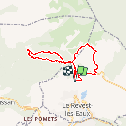
Ruta Senderismo de 17,2 km a descubrir en Provenza-Alpes-Costa Azul, Var, Le Revest-les-Eaux. Esta ruta ha sido propuesta por francisdean.
Descripción
Jolie randonnée. Suivre le tracé. En période de pluie la traversée du gué après le petit lac de Roboeuf nécessite le port de chaussures étanches ou de bottes. A part cela aucune difficulté particulière. A partir du four à cade que l'ont aperçoit en contre-bas sur la droite, le chemin devient incertain sur environ 500 mètres. On rejoint un bon chemin après le fond du vallon.
Localización
Comentarios
Excursiones cerca
![Excursión Senderismo Ollioules - SityTrail - 1041295 - le-destel-grotte-des-joncs - Photo](https://media.geolcdn.com/t/375/260/b00c002a-3425-4f84-ae24-7620ef9e7315.jpg&format=jpg&maxdim=2)
![Senderismo Senderismo](https://static1.geolcdn.com/sitytour/trail-icons/101.png)
Senderismo
![](/images/other/stat-length.png)
![](https://static1.geolcdn.com/siteimages/upload/files/16400158638029165_repeat_loop_refresh_sync_direction_icon.png)
![Excursión Senderismo Solliès-Toucas - Morières : la Garoute et la Baume des Lumes - Photo](https://media.geolcdn.com/t/375/260/3e6ddcf9-f59d-47f4-a0ee-582c12a1d8d8.jpg&format=jpg&maxdim=2)
![Senderismo Senderismo](https://static1.geolcdn.com/sitytour/trail-icons/101.png)
Senderismo
![](/images/other/stat-length.png)
![](https://static1.geolcdn.com/siteimages/upload/files/16400158638029165_repeat_loop_refresh_sync_direction_icon.png)
![Excursión Senderismo Le Revest-les-Eaux - Boucle: La ripelle - Source de la ripelle - Le Chateau de Tourris - Les grottes de sable - La carrière aux fourmis - Les puits renovés de M. Lambicchi - Les ruines des Olivières - La ferme de la Touravelle - à Le Revest-les-Eaux - Photo](https://media.geolcdn.com/t/375/260/0dbff04b-2a84-4eed-a6e8-7a56bc074382.jpg&format=jpg&maxdim=2)
![Senderismo Senderismo](https://static1.geolcdn.com/sitytour/trail-icons/101.png)
Senderismo
![](/images/other/stat-length.png)
![](https://static1.geolcdn.com/siteimages/upload/files/16400158638029165_repeat_loop_refresh_sync_direction_icon.png)
![Excursión Senderismo Tolón - Faron versant Nord - Photo](https://media.geolcdn.com/t/375/260/40a1f88d-10a7-4595-84a1-0086eecb7f84.jpg&format=jpg&maxdim=2)
![Senderismo Senderismo](https://static1.geolcdn.com/sitytour/trail-icons/101.png)
Senderismo
![](/images/other/stat-length.png)
![](https://static1.geolcdn.com/siteimages/upload/files/16400158638029165_repeat_loop_refresh_sync_direction_icon.png)
![Excursión Senderismo Tolón - Faron côté nord - Photo](https://media.geolcdn.com/t/375/260/1a97f987-c174-4fc8-a435-d00586c57288.jpg&format=jpg&maxdim=2)
![Senderismo Senderismo](https://static1.geolcdn.com/sitytour/trail-icons/101.png)
Senderismo
![](/images/other/stat-length.png)
![](https://static1.geolcdn.com/siteimages/upload/files/16400158638029165_repeat_loop_refresh_sync_direction_icon.png)
![Excursión Senderismo Solliès-Toucas - SityTrail - siou blanc - Photo](https://media.geolcdn.com/t/375/260/2137f2fb-f7c1-49df-9712-76654d4b67c0.jpg&format=jpg&maxdim=2)
![Senderismo Senderismo](https://static1.geolcdn.com/sitytour/trail-icons/101.png)
Senderismo
![](/images/other/stat-length.png)
![](https://static1.geolcdn.com/siteimages/upload/files/16400158638029165_repeat_loop_refresh_sync_direction_icon.png)
![Excursión Senderismo Le Revest-les-Eaux - 83 barrage revest les eaux 24-05-2021 - Photo](https://media.geolcdn.com/t/375/260/1106c6f7-fedf-4077-96a1-b48580038b53.jpg&format=jpg&maxdim=2)
![Senderismo Senderismo](https://static1.geolcdn.com/sitytour/trail-icons/101.png)
Senderismo
![](/images/other/stat-length.png)
![](https://static1.geolcdn.com/siteimages/upload/files/16400158638029165_repeat_loop_refresh_sync_direction_icon.png)
![Excursión Senderismo La Valette-du-Var - SityTrail - Le tour du coudon - Photo](https://media.geolcdn.com/t/375/260/c1a593ce-5178-4a51-a2b4-9401a3556db4.jpg&format=jpg&maxdim=2)
![Senderismo Senderismo](https://static1.geolcdn.com/sitytour/trail-icons/101.png)
Senderismo
![](/images/other/stat-length.png)
![](https://static1.geolcdn.com/siteimages/upload/files/16400158638029165_repeat_loop_refresh_sync_direction_icon.png)
![Excursión Senderismo Tolón - Tour Du Baou par falaises - Photo](https://media.geolcdn.com/t/375/260/ext.jpg?maxdim=2&url=https%3A%2F%2Fservices.sitytrail.com%2FGeolivesWS%2FDownloadMedia.ashx%3FTrailID%3D166161%26Media%3D20121215151840.jpeg)
![Senderismo Senderismo](https://static1.geolcdn.com/sitytour/trail-icons/101.png)
Senderismo
![](/images/other/stat-length.png)
![](https://static1.geolcdn.com/siteimages/upload/files/16400158638029165_repeat_loop_refresh_sync_direction_icon.png)