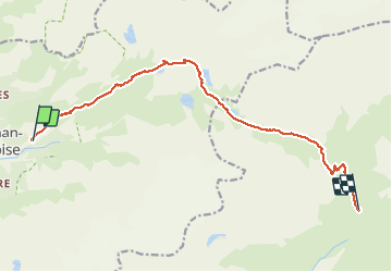
![](/images/other/stat-length.png)
![Excursión Senderismo Pralognan-la-Vanoise - tour des glaciers de la Vanoise jour 1 refuge d'entre deux eaux depuis pralognan - Photo](https://media.geolcdn.com/t/1900/400/ext.pjpeg?maxdim=2&url=https%3A%2F%2Fstatic1.geolcdn.com%2Fsiteimages%2Fupload%2Ffiles%2F1553511878bg_sport_marche.png)
tour des glaciers de la Vanoise jour 1 refuge d'entre deux eaux depuis pralognan
scalpy
Usuario
![Longitud](/images/other/stat-length.png)
![Altitud máxima](https://static1.geolcdn.com/siteimages/upload/files/1508320355ic_sort_altitude_max_24dp.png)
![Desnivel positivo](https://static1.geolcdn.com/siteimages/upload/files/1508320355ic_sort_den_pos_24dp.png)
![Km-Effort](/images/other/stat-length.png)
![Altitud mínima](https://static1.geolcdn.com/siteimages/upload/files/1508320355ic_sort_altitude_min_24dp.png)
![Desnivel negativo](https://static1.geolcdn.com/siteimages/upload/files/1508320355ic_sort_den_neg_24dp.png)
![Boucle](https://static1.geolcdn.com/siteimages/upload/files/16400158638029165_repeat_loop_refresh_sync_direction_icon.png)
![Senderismo](https://static1.geolcdn.com/sitytour/trail-icons/101.png)
6h43
Dificultad : Difícil
![Escanee este código QR para abrir la excursión en la aplicación SityTrail](https://capi.geolives.com/qq0zvz2zws4bq2lad0pu/sitytour/trails/2466944/qr.png?size=200)
Aplicación GPS de excursión GRATIS
A propósito
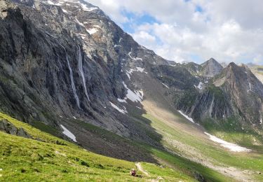
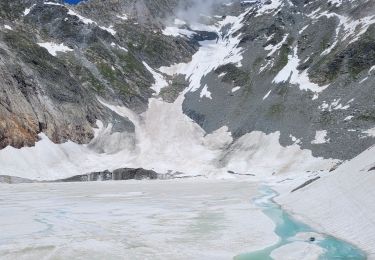
Ruta Senderismo de 13,1 km a descubrir en Auvergne-Rhône-Alpes, Saboya, Pralognan-la-Vanoise. Esta ruta ha sido propuesta por scalpy.
Descripción
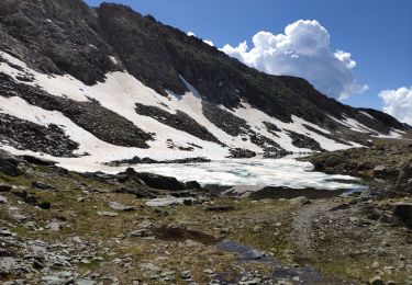
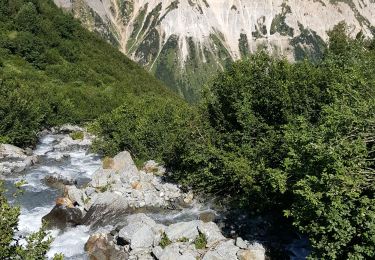
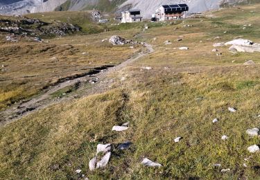
jour 1 du tour des glaciers délabrés vanoise
pas de grosses difficultés. bcp de marmottes et bouquetins. Quelques beaux reves en traversée quand même. Paysages magnifiques temps superbe en ce 4 juillet 2020. Arrivee au refuge application des mesures covid
Localización
Comentarios
Excursiones cerca
![Excursión Senderismo Pralognan-la-Vanoise - Vanoise 2021 : refuge de la Vanoise au refuge de la Valette par les glacier et le dôme des Sonnailles (-07-18).ori - Photo](https://media.geolcdn.com/t/375/260/aa7290a4-f49c-4ba3-9cdb-5f8383ee7015.jpg&format=jpg&maxdim=2)
![Senderismo Senderismo](https://static1.geolcdn.com/sitytour/trail-icons/101.png)
Senderismo
![](/images/other/stat-length.png)
![](https://static1.geolcdn.com/siteimages/upload/files/16400158638029165_repeat_loop_refresh_sync_direction_icon.png)
![Excursión Senderismo Pralognan-la-Vanoise - Pralognan - Les Prioux Lac de Chalet Clou - Photo](https://media.geolcdn.com/t/375/260/aef0b6ed-57e6-4d04-a75d-d2ffe6e61cd4.jpg&format=jpg&maxdim=2)
![Senderismo Senderismo](https://static1.geolcdn.com/sitytour/trail-icons/101.png)
Senderismo
![](/images/other/stat-length.png)
![](https://static1.geolcdn.com/siteimages/upload/files/16400158638029165_repeat_loop_refresh_sync_direction_icon.png)
![Excursión Senderismo Pralognan-la-Vanoise - Pralognan - la crête du mont Charvet - Photo](https://media.geolcdn.com/t/375/260/54cee105-6456-408f-be19-9af4b98c1ac1.jpg&format=jpg&maxdim=2)
![Senderismo Senderismo](https://static1.geolcdn.com/sitytour/trail-icons/101.png)
Senderismo
![](/images/other/stat-length.png)
![](https://static1.geolcdn.com/siteimages/upload/files/16400158638029165_repeat_loop_refresh_sync_direction_icon.png)
![Excursión Senderismo Val-Cenis - traversée Valette f faure - Photo](https://media.geolcdn.com/t/375/260/1679692e-b77c-47af-aee2-08c69ff92bec.jpg&format=jpg&maxdim=2)
![Senderismo Senderismo](https://static1.geolcdn.com/sitytour/trail-icons/101.png)
Senderismo
![](/images/other/stat-length.png)
![](https://static1.geolcdn.com/siteimages/upload/files/16400158638029165_repeat_loop_refresh_sync_direction_icon.png)
![Excursión Senderismo Pralognan-la-Vanoise - pointe de Leschaux - Photo](https://media.geolcdn.com/t/375/260/c0179711-7974-4489-9ffb-171084fcf8a1.jpg&format=jpg&maxdim=2)
![Senderismo Senderismo](https://static1.geolcdn.com/sitytour/trail-icons/101.png)
Senderismo
![](/images/other/stat-length.png)
![](https://static1.geolcdn.com/siteimages/upload/files/16400158638029165_repeat_loop_refresh_sync_direction_icon.png)
![Excursión Senderismo Planay - la cascade de la Vuzelle - Photo](https://media.geolcdn.com/t/375/260/04c5b92c-2692-443b-b1c5-903e48f44ec5.jpg&format=jpg&maxdim=2)
![Senderismo Senderismo](https://static1.geolcdn.com/sitytour/trail-icons/101.png)
Senderismo
![](/images/other/stat-length.png)
![](https://static1.geolcdn.com/siteimages/upload/files/16400158638029165_repeat_loop_refresh_sync_direction_icon.png)
![Excursión Senderismo Pralognan-la-Vanoise - traversée des Fontanettes aux Prioux par le col du Grand marchet - Photo](https://media.geolcdn.com/t/375/260/24a33514-db38-4400-a38f-98ffcbd53fe7.jpg&format=jpg&maxdim=2)
![Senderismo Senderismo](https://static1.geolcdn.com/sitytour/trail-icons/101.png)
Senderismo
![](/images/other/stat-length.png)
![](https://static1.geolcdn.com/siteimages/upload/files/16400158638029165_repeat_loop_refresh_sync_direction_icon.png)
![Excursión Senderismo Pralognan-la-Vanoise - le lac de la patinoire - Photo](https://media.geolcdn.com/t/375/260/88bae2e9-35f9-4ca5-a526-616594e07db8.jpg&format=jpg&maxdim=2)
![Senderismo Senderismo](https://static1.geolcdn.com/sitytour/trail-icons/101.png)
Senderismo
![](/images/other/stat-length.png)
![](https://static1.geolcdn.com/siteimages/upload/files/16400158638029165_repeat_loop_refresh_sync_direction_icon.png)
![Excursión Senderismo Pralognan-la-Vanoise - col de napremont - Photo](https://media.geolcdn.com/t/375/260/6fea95cc-6da2-44f1-9ef9-b36a9d856ac2.jpg&format=jpg&maxdim=2)
![Senderismo Senderismo](https://static1.geolcdn.com/sitytour/trail-icons/101.png)
Senderismo
![](/images/other/stat-length.png)
![](https://static1.geolcdn.com/siteimages/upload/files/16400158638029165_repeat_loop_refresh_sync_direction_icon.png)