![](/images/other/stat-length.png)
![Excursión Senderismo Mas-Saint-Chély - Mas St Chely Mont Servy 5 km - Photo](https://media.geolcdn.com/t/1900/400/af00a001-80c4-4ac5-94a0-430ed07578bd.jpg&format=pjpeg&maxdim=2)
Mas St Chely Mont Servy 5 km
rvapeldo
Usuario GUIDE
![Longitud](/images/other/stat-length.png)
Longitud
5,5 km
![Altitud máxima](https://static1.geolcdn.com/siteimages/upload/files/1508320355ic_sort_altitude_max_24dp.png)
Altitud máxima
1106 m
![Desnivel positivo](https://static1.geolcdn.com/siteimages/upload/files/1508320355ic_sort_den_pos_24dp.png)
Desnivel positivo
173 m
![Km-Effort](/images/other/stat-length.png)
Km-Effort
7,8 km
![Altitud mínima](https://static1.geolcdn.com/siteimages/upload/files/1508320355ic_sort_altitude_min_24dp.png)
Altitud mínima
946 m
![Desnivel negativo](https://static1.geolcdn.com/siteimages/upload/files/1508320355ic_sort_den_neg_24dp.png)
Desnivel negativo
172 m
![Boucle](https://static1.geolcdn.com/siteimages/upload/files/16400158638029165_repeat_loop_refresh_sync_direction_icon.png)
Boucle
Sí
Fecha de creación :
2020-07-07 07:47:12.0
Última modificación :
2020-07-11 20:45:22.881
![Senderismo](https://static1.geolcdn.com/sitytour/trail-icons/101.png)
1h38
Dificultad : Fácil
![Escanee este código QR para abrir la excursión en la aplicación SityTrail](https://capi.geolives.com/qq0zvz2zws4bq2lad0pu/sitytour/trails/2465480/qr.png?size=200)
Aplicación GPS de excursión GRATIS
A propósito
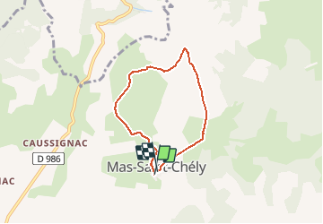
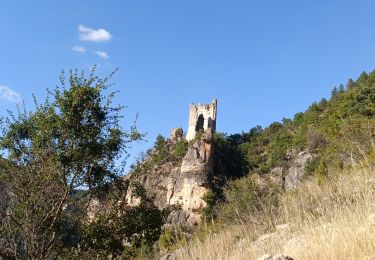
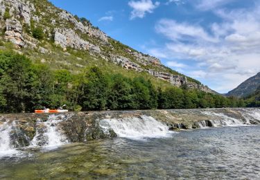
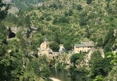
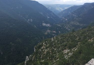
Ruta Senderismo de 5,5 km a descubrir en Occitania, Lozère, Mas-Saint-Chély. Esta ruta ha sido propuesta por rvapeldo.
Descripción
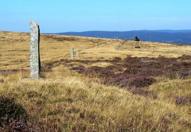
petite promenade au Mont Servy, qui est aussi le nom de l'hotel local, d'où une vue agréable attend le marcheur. Retour par le GR de pays.
Localización
País:
France
Región :
Occitania
Departamento/provincia :
Lozère
Municipio :
Mas-Saint-Chély
Localidad:
Unknown
Salida:(Dec)
Salida:(UTM)
531541 ; 4906212 (31T) N.
Comentarios
Excursiones cerca
![Excursión Senderismo Gorges du Tarn Causses - Sentier de St-Chély du Tarn - Photo](https://media.geolcdn.com/t/375/260/ext.jpg?maxdim=2&url=https%3A%2F%2Fservices.sitytrail.com%2FGeolivesWS%2FDownloadMedia.ashx%3FTrailID%3D111743%26Media%3D8149_6.jpg)
![Senderismo Senderismo](https://static1.geolcdn.com/sitytour/trail-icons/101.png)
Sentier de St-Chély du Tarn
Senderismo
Muy difícil
(3)
Gorges du Tarn Causses,
Occitania,
Lozère,
France
![](/images/other/stat-length.png)
15,8 km | 25 km-effort
4h 30min
![](https://static1.geolcdn.com/siteimages/upload/files/16400158638029165_repeat_loop_refresh_sync_direction_icon.png)
Sí
![Excursión Senderismo Gorges du Tarn Causses - Saint Chely 17 km - Photo](https://media.geolcdn.com/t/375/260/fd8a2a6b-4459-4f35-901e-690e418ad6dc.jpg&format=jpg&maxdim=2)
![Senderismo Senderismo](https://static1.geolcdn.com/sitytour/trail-icons/101.png)
Saint Chely 17 km
Senderismo
Medio
Gorges du Tarn Causses,
Occitania,
Lozère,
France
![](/images/other/stat-length.png)
17,1 km | 27 km-effort
6h 7min
![](https://static1.geolcdn.com/siteimages/upload/files/16400158638029165_repeat_loop_refresh_sync_direction_icon.png)
Sí
![Excursión Senderismo Gorges du Tarn Causses - rando saint Charly du Tarn par le haut et retour par le bas - Photo](https://media.geolcdn.com/t/375/260/ext.jpg?maxdim=2&url=https%3A%2F%2Fservices.sitytrail.com%2FGeolivesWS%2FDownloadMedia.ashx%3FTrailID%3D1029620%26Media%3Dfix__20180827152528.jpg)
![Senderismo Senderismo](https://static1.geolcdn.com/sitytour/trail-icons/101.png)
rando saint Charly du Tarn par le haut et retour par le bas
Senderismo
Medio
Gorges du Tarn Causses,
Occitania,
Lozère,
France
![](/images/other/stat-length.png)
16,7 km | 26 km-effort
6h 3min
![](https://static1.geolcdn.com/siteimages/upload/files/16400158638029165_repeat_loop_refresh_sync_direction_icon.png)
Sí
![Excursión Senderismo Mas-Saint-Chély - 2023/09 Tarn. la malene - Photo](https://media.geolcdn.com/t/375/260/585a2f6b-7c17-4390-9b10-ab1e6a527020.jpg&format=jpg&maxdim=2)
![Senderismo Senderismo](https://static1.geolcdn.com/sitytour/trail-icons/101.png)
2023/09 Tarn. la malene
Senderismo
Difícil
Mas-Saint-Chély,
Occitania,
Lozère,
France
![](/images/other/stat-length.png)
21 km | 31 km-effort
6h 52min
![](https://static1.geolcdn.com/siteimages/upload/files/16400158638029165_repeat_loop_refresh_sync_direction_icon.png)
Sí
![Excursión Piragüismo Gorges du Tarn Causses - Descente du Tarn - Photo](https://media.geolcdn.com/t/375/260/927e2dd5-b45a-426d-ac63-13be2e6378df.jpg&format=jpg&maxdim=2)
![Piragüismo Piragüismo](https://static1.geolcdn.com/sitytour/trail-icons/703.png)
Descente du Tarn
Piragüismo
Fácil
Gorges du Tarn Causses,
Occitania,
Lozère,
France
![](/images/other/stat-length.png)
18,7 km | 23 km-effort
4h 41min
![](https://static1.geolcdn.com/siteimages/upload/files/16400158638029165_repeat_loop_refresh_sync_direction_icon.png)
No
![Excursión Senderismo Gorges du Tarn Causses - St Chély du Tarn sentier du cirque - Photo](https://media.geolcdn.com/t/375/260/d1e0b352-9279-49a7-af06-dd61814c1a0d.jpg&format=jpg&maxdim=2)
![Senderismo Senderismo](https://static1.geolcdn.com/sitytour/trail-icons/101.png)
St Chély du Tarn sentier du cirque
Senderismo
Medio
Gorges du Tarn Causses,
Occitania,
Lozère,
France
![](/images/other/stat-length.png)
16,6 km | 26 km-effort
5h 48min
![](https://static1.geolcdn.com/siteimages/upload/files/16400158638029165_repeat_loop_refresh_sync_direction_icon.png)
Sí
![Excursión Senderismo Gorges du Tarn Causses - Laval du Tarn (boucle) - Photo](https://media.geolcdn.com/t/375/260/ext.jpg?maxdim=2&url=https%3A%2F%2Fservices.sitytrail.com%2FGeolivesWS%2FDownloadMedia.ashx%3FTrailID%3D1019167%26Media%3D20180809092152.jpg)
![Senderismo Senderismo](https://static1.geolcdn.com/sitytour/trail-icons/101.png)
Laval du Tarn (boucle)
Senderismo
Fácil
Gorges du Tarn Causses,
Occitania,
Lozère,
France
![](/images/other/stat-length.png)
11,5 km | 15,9 km-effort
2h 48min
![](https://static1.geolcdn.com/siteimages/upload/files/16400158638029165_repeat_loop_refresh_sync_direction_icon.png)
Sí
![Excursión Senderismo Mas-Saint-Chély - La draille du Languedoc PR® - Photo](https://media.geolcdn.com/t/375/260/ext.jpg?maxdim=2&url=https%3A%2F%2Fservices.sitytrail.com%2FGeolivesWS%2FDownloadMedia.ashx%3FTrailID%3D316751%26Media%3D4665_1.jpg)
![Senderismo Senderismo](https://static1.geolcdn.com/sitytour/trail-icons/101.png)
La draille du Languedoc PR®
Senderismo
Muy difícil
Mas-Saint-Chély,
Occitania,
Lozère,
France
![](/images/other/stat-length.png)
19,7 km | 31 km-effort
6h 0min
![](https://static1.geolcdn.com/siteimages/upload/files/16400158638029165_repeat_loop_refresh_sync_direction_icon.png)
Sí
![Excursión Senderismo Gorges du Tarn Causses - les vignes - Photo](https://media.geolcdn.com/t/375/260/330cf850-dffc-429c-b010-e1f9337b383c.jpg&format=jpg&maxdim=2)
![Senderismo Senderismo](https://static1.geolcdn.com/sitytour/trail-icons/101.png)
les vignes
Senderismo
Muy difícil
Gorges du Tarn Causses,
Occitania,
Lozère,
France
![](/images/other/stat-length.png)
24 km | 34 km-effort
8h 51min
![](https://static1.geolcdn.com/siteimages/upload/files/16400158638029165_repeat_loop_refresh_sync_direction_icon.png)
No