![](/images/other/stat-length.png)
![Excursión Senderismo Teyssières - randogps26-447 - Photo](https://media.geolcdn.com/t/1900/400/ext.pjpeg?maxdim=2&url=https%3A%2F%2Fstatic1.geolcdn.com%2Fsiteimages%2Fupload%2Ffiles%2F1553511878bg_sport_marche.png)
randogps26-447
aitkhedache
Usuario
![Longitud](/images/other/stat-length.png)
Longitud
13,8 km
![Altitud máxima](https://static1.geolcdn.com/siteimages/upload/files/1508320355ic_sort_altitude_max_24dp.png)
Altitud máxima
1205 m
![Desnivel positivo](https://static1.geolcdn.com/siteimages/upload/files/1508320355ic_sort_den_pos_24dp.png)
Desnivel positivo
808 m
![Km-Effort](/images/other/stat-length.png)
Km-Effort
25 km
![Altitud mínima](https://static1.geolcdn.com/siteimages/upload/files/1508320355ic_sort_altitude_min_24dp.png)
Altitud mínima
644 m
![Desnivel negativo](https://static1.geolcdn.com/siteimages/upload/files/1508320355ic_sort_den_neg_24dp.png)
Desnivel negativo
811 m
![Boucle](https://static1.geolcdn.com/siteimages/upload/files/16400158638029165_repeat_loop_refresh_sync_direction_icon.png)
Boucle
Sí
Fecha de creación :
2020-07-05 07:48:28.357
Última modificación :
2020-07-05 08:41:18.914
![Senderismo](https://static1.geolcdn.com/sitytour/trail-icons/101.png)
4h58
Dificultad : Muy difícil
![Escanee este código QR para abrir la excursión en la aplicación SityTrail](https://capi.geolives.com/qq0zvz2zws4bq2lad0pu/sitytour/trails/2462151/qr.png?size=200)
Aplicación GPS de excursión GRATIS
A propósito
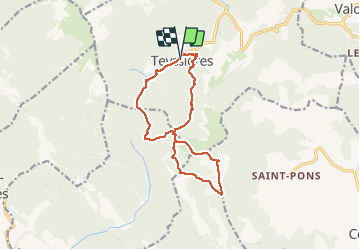
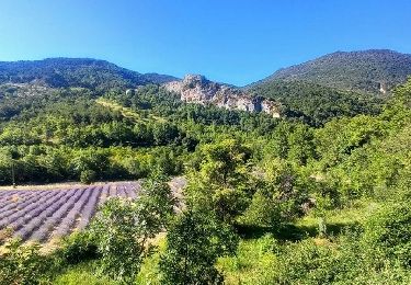
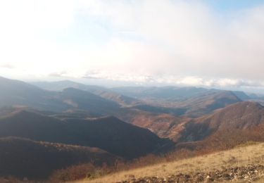
Ruta Senderismo de 13,8 km a descubrir en Auvergne-Rhône-Alpes, Drôme, Teyssières. Esta ruta ha sido propuesta por aitkhedache.
Descripción
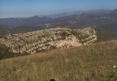
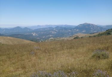
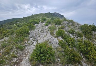
Très belle balade qui délivre une vue à 360° sur le Dévoluy et le Vercors ...
Un peu physique en raison de la distance.
Localización
País:
France
Región :
Auvergne-Rhône-Alpes
Departamento/provincia :
Drôme
Municipio :
Teyssières
Localidad:
Unknown
Salida:(Dec)
Salida:(UTM)
669605 ; 4924069 (31T) N.
Comentarios
Excursiones cerca
![Excursión Senderismo Rousset-les-Vignes - Rousset- La Lance - Photo](https://media.geolcdn.com/t/375/260/84d3931f-2eee-4f55-959d-db8a6d419ca0.jpg&format=jpg&maxdim=2)
![Senderismo Senderismo](https://static1.geolcdn.com/sitytour/trail-icons/101.png)
Rousset- La Lance
Senderismo
Difícil
(1)
Rousset-les-Vignes,
Auvergne-Rhône-Alpes,
Drôme,
France
![](/images/other/stat-length.png)
14 km | 26 km-effort
2h 55min
![](https://static1.geolcdn.com/siteimages/upload/files/16400158638029165_repeat_loop_refresh_sync_direction_icon.png)
Sí
![Excursión Senderismo Teyssières - 26 cougoir zel - Photo](https://media.geolcdn.com/t/375/260/73f2a032-a019-4e88-aecb-d5d32d3ee0aa.jpg&format=jpg&maxdim=2)
![Senderismo Senderismo](https://static1.geolcdn.com/sitytour/trail-icons/101.png)
26 cougoir zel
Senderismo
Medio
Teyssières,
Auvergne-Rhône-Alpes,
Drôme,
France
![](/images/other/stat-length.png)
13 km | 23 km-effort
6h 24min
![](https://static1.geolcdn.com/siteimages/upload/files/16400158638029165_repeat_loop_refresh_sync_direction_icon.png)
No
![Excursión Senderismo Venterol - le cougoir - Photo](https://media.geolcdn.com/t/375/260/37fd75d5-0091-4964-9bad-4ec775b5e571.jpg&format=jpg&maxdim=2)
![Senderismo Senderismo](https://static1.geolcdn.com/sitytour/trail-icons/101.png)
le cougoir
Senderismo
Medio
Venterol,
Auvergne-Rhône-Alpes,
Drôme,
France
![](/images/other/stat-length.png)
11,4 km | 19,7 km-effort
3h 46min
![](https://static1.geolcdn.com/siteimages/upload/files/16400158638029165_repeat_loop_refresh_sync_direction_icon.png)
No
![Excursión Senderismo Teyssières - Randonnée au départ de Teyssières (Le Cougoir, La Lance) - Photo](https://media.geolcdn.com/t/375/260/94a27539-2910-4367-af66-73c1555d2126.jpg&format=jpg&maxdim=2)
![Senderismo Senderismo](https://static1.geolcdn.com/sitytour/trail-icons/101.png)
Randonnée au départ de Teyssières (Le Cougoir, La Lance)
Senderismo
Muy difícil
Teyssières,
Auvergne-Rhône-Alpes,
Drôme,
France
![](/images/other/stat-length.png)
22 km | 40 km-effort
9h 2min
![](https://static1.geolcdn.com/siteimages/upload/files/16400158638029165_repeat_loop_refresh_sync_direction_icon.png)
Sí
![Excursión Senderismo Teyssières - 2022-09-27_10h31m20_Teyssieres Cougoir 12km - Photo](https://media.geolcdn.com/t/375/260/c1b90102-3f17-42c6-9eaa-274a207a9df3.jpg&format=jpg&maxdim=2)
![Senderismo Senderismo](https://static1.geolcdn.com/sitytour/trail-icons/101.png)
2022-09-27_10h31m20_Teyssieres Cougoir 12km
Senderismo
Muy difícil
Teyssières,
Auvergne-Rhône-Alpes,
Drôme,
France
![](/images/other/stat-length.png)
11,9 km | 21 km-effort
4h 50min
![](https://static1.geolcdn.com/siteimages/upload/files/16400158638029165_repeat_loop_refresh_sync_direction_icon.png)
Sí
![Excursión Senderismo Valouse - mielandre - Photo](https://media.geolcdn.com/t/375/260/f5718be0-7b70-47ac-8b04-32aa7a492791.jpg&format=jpg&maxdim=2)
![Senderismo Senderismo](https://static1.geolcdn.com/sitytour/trail-icons/101.png)
mielandre
Senderismo
Muy difícil
Valouse,
Auvergne-Rhône-Alpes,
Drôme,
France
![](/images/other/stat-length.png)
11,3 km | 23 km-effort
6h 34min
![](https://static1.geolcdn.com/siteimages/upload/files/16400158638029165_repeat_loop_refresh_sync_direction_icon.png)
Sí
![Excursión Senderismo Valouse - 2021_11_14 - Photo](https://media.geolcdn.com/t/375/260/82af798d-3a29-4075-90aa-5e2c8e883cf5.jpg&format=jpg&maxdim=2)
![Senderismo Senderismo](https://static1.geolcdn.com/sitytour/trail-icons/101.png)
2021_11_14
Senderismo
Fácil
Valouse,
Auvergne-Rhône-Alpes,
Drôme,
France
![](/images/other/stat-length.png)
10,5 km | 22 km-effort
3h 33min
![](https://static1.geolcdn.com/siteimages/upload/files/16400158638029165_repeat_loop_refresh_sync_direction_icon.png)
Sí
![Excursión Senderismo Valouse - 2021_11_14 Miélandre - Photo](https://media.geolcdn.com/t/375/260/32d9fd14-76e6-4731-8210-b2cb388c409f.jpg&format=jpg&maxdim=2)
![Senderismo Senderismo](https://static1.geolcdn.com/sitytour/trail-icons/101.png)
2021_11_14 Miélandre
Senderismo
Muy difícil
Valouse,
Auvergne-Rhône-Alpes,
Drôme,
France
![](/images/other/stat-length.png)
10,5 km | 22 km-effort
3h 50min
![](https://static1.geolcdn.com/siteimages/upload/files/16400158638029165_repeat_loop_refresh_sync_direction_icon.png)
Sí
![Excursión Senderismo Venterol - Col de la Sausse par la Combe de Sauve - Photo](https://media.geolcdn.com/t/375/260/ext.jpg?maxdim=2&url=https%3A%2F%2Fstatic1.geolcdn.com%2Fsiteimages%2Fupload%2Ffiles%2F1553511878bg_sport_marche.png)
![Senderismo Senderismo](https://static1.geolcdn.com/sitytour/trail-icons/101.png)
Col de la Sausse par la Combe de Sauve
Senderismo
Muy fácil
(1)
Venterol,
Auvergne-Rhône-Alpes,
Drôme,
France
![](/images/other/stat-length.png)
5,3 km | 8,7 km-effort
1h 46min
![](https://static1.geolcdn.com/siteimages/upload/files/16400158638029165_repeat_loop_refresh_sync_direction_icon.png)
Sí