![](/images/other/stat-length.png)
![Excursión Senderismo Annot - Les grés d'Annot: Jardins et chambre du Roi - Photo](https://media.geolcdn.com/t/1900/400/2b865830-3fe2-49c9-9a69-3696cb0f2f88.jpg&format=pjpeg&maxdim=2)
Les grés d'Annot: Jardins et chambre du Roi
lviallet
Usuario
![Longitud](/images/other/stat-length.png)
![Altitud máxima](https://static1.geolcdn.com/siteimages/upload/files/1508320355ic_sort_altitude_max_24dp.png)
![Desnivel positivo](https://static1.geolcdn.com/siteimages/upload/files/1508320355ic_sort_den_pos_24dp.png)
![Km-Effort](/images/other/stat-length.png)
![Altitud mínima](https://static1.geolcdn.com/siteimages/upload/files/1508320355ic_sort_altitude_min_24dp.png)
![Desnivel negativo](https://static1.geolcdn.com/siteimages/upload/files/1508320355ic_sort_den_neg_24dp.png)
![Boucle](https://static1.geolcdn.com/siteimages/upload/files/16400158638029165_repeat_loop_refresh_sync_direction_icon.png)
![Senderismo](https://static1.geolcdn.com/sitytour/trail-icons/101.png)
3h01
Dificultad : Medio
![Escanee este código QR para abrir la excursión en la aplicación SityTrail](https://capi.geolives.com/qq0zvz2zws4bq2lad0pu/sitytour/trails/2455106/qr.png?size=200)
Aplicación GPS de excursión GRATIS
A propósito
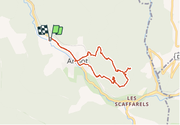
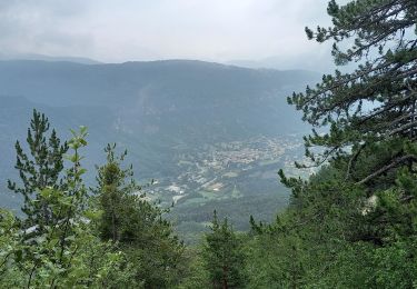
Ruta Senderismo de 8,7 km a descubrir en Provenza-Alpes-Costa Azul, Alpes de Alta Provenza, Annot. Esta ruta ha sido propuesta por lviallet.
Descripción
Très jolie ballade.
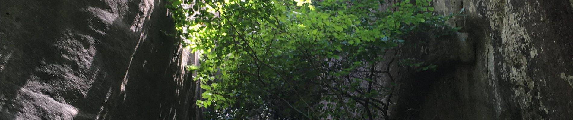
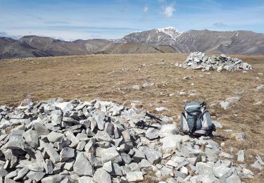
Au début de l'ère tertiaire, il y a 65 millions d'années, la mer s'est retirée en déposant localement des sables gréseux. Quelques millier d'années plus tard, ces sables, liés par des calcaires, se sont solidifiés formant de grandes falaises. Puis sous l'action de l'érosion, les falaises se sont disloquées en de multitudes blocs.
Localización
Comentarios
Excursiones cerca
![Excursión A pie Annot - Le Grès d'Annot - Photo](https://media.geolcdn.com/t/375/260/d494c9f4-04f5-4184-be97-f5fea23e1191.jpeg&format=jpg&maxdim=2)
![A pie A pie](https://static1.geolcdn.com/sitytour/trail-icons/100.png)
A pie
![](/images/other/stat-length.png)
![](https://static1.geolcdn.com/siteimages/upload/files/16400158638029165_repeat_loop_refresh_sync_direction_icon.png)
![Excursión Esquí de fondo Castellet-lès-Sausses - mourre Frey te tête de travers - Photo](https://media.geolcdn.com/t/375/260/1b767a21-1868-437d-b876-59d00a73f0ab.jpg&format=jpg&maxdim=2)
![Esquí de fondo Esquí de fondo](https://static1.geolcdn.com/sitytour/trail-icons/503.png)
Esquí de fondo
![](/images/other/stat-length.png)
![](https://static1.geolcdn.com/siteimages/upload/files/16400158638029165_repeat_loop_refresh_sync_direction_icon.png)
![Excursión Senderismo Annot - J4 Annot - Photo](https://media.geolcdn.com/t/375/260/be9d9d12-b8a6-45a8-bd70-6f8cacf32730.jpg&format=jpg&maxdim=2)
![Senderismo Senderismo](https://static1.geolcdn.com/sitytour/trail-icons/101.png)
Senderismo
![](/images/other/stat-length.png)
![](https://static1.geolcdn.com/siteimages/upload/files/16400158638029165_repeat_loop_refresh_sync_direction_icon.png)
![Senderismo Senderismo](https://static1.geolcdn.com/sitytour/trail-icons/101.png)
Senderismo
![](/images/other/stat-length.png)
![](https://static1.geolcdn.com/siteimages/upload/files/16400158638029165_repeat_loop_refresh_sync_direction_icon.png)
![Excursión Senderismo Annot - Rando gastro Roncharel - Photo](https://media.geolcdn.com/t/375/260/4e3f8487-9887-4ec3-94b2-d5bbd50aefe8.jpg&format=jpg&maxdim=2)
![Senderismo Senderismo](https://static1.geolcdn.com/sitytour/trail-icons/101.png)
Senderismo
![](/images/other/stat-length.png)
![](https://static1.geolcdn.com/siteimages/upload/files/16400158638029165_repeat_loop_refresh_sync_direction_icon.png)
![Excursión Senderismo Annot - Les grès d'Annot - Photo](https://media.geolcdn.com/t/375/260/ext.jpg?maxdim=2&url=https%3A%2F%2Fstatic1.geolcdn.com%2Fsiteimages%2Fupload%2Ffiles%2F1553511878bg_sport_marche.png)
![Senderismo Senderismo](https://static1.geolcdn.com/sitytour/trail-icons/101.png)
Senderismo
![](/images/other/stat-length.png)
![](https://static1.geolcdn.com/siteimages/upload/files/16400158638029165_repeat_loop_refresh_sync_direction_icon.png)
![Excursión Senderismo Castellet-lès-Sausses - Tête de travers et Mourre Frey, du Col du Fam - Photo](https://media.geolcdn.com/t/375/260/a4176451-cb19-4ec9-86ca-b1e3e647aa87.jpg&format=jpg&maxdim=2)
![Senderismo Senderismo](https://static1.geolcdn.com/sitytour/trail-icons/101.png)
Senderismo
![](/images/other/stat-length.png)
![](https://static1.geolcdn.com/siteimages/upload/files/16400158638029165_repeat_loop_refresh_sync_direction_icon.png)
![Excursión Senderismo Annot - Rando bleue - Photo](https://media.geolcdn.com/t/375/260/94ab7e9b-3b20-4840-b15c-d5a4c12ad390.jpg&format=jpg&maxdim=2)
![Senderismo Senderismo](https://static1.geolcdn.com/sitytour/trail-icons/101.png)
Senderismo
![](/images/other/stat-length.png)
![](https://static1.geolcdn.com/siteimages/upload/files/16400158638029165_repeat_loop_refresh_sync_direction_icon.png)
![Excursión Senderismo Braux - Rando Pieŕre qui tremble Chabrieres Peloussis Argenton - Photo](https://media.geolcdn.com/t/375/260/cfc0cc00-9a69-459b-9e00-f152d8d54736.jpg&format=jpg&maxdim=2)
![Senderismo Senderismo](https://static1.geolcdn.com/sitytour/trail-icons/101.png)
Senderismo
![](/images/other/stat-length.png)
![](https://static1.geolcdn.com/siteimages/upload/files/16400158638029165_repeat_loop_refresh_sync_direction_icon.png)