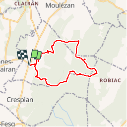
![](/images/other/stat-length.png)
![Excursión Senderismo Montmirat - MONTMIRAT - BOIS DE LENS - 13.7Km - 04h30 - Dénivelé 160 m - Photo](https://media.geolcdn.com/t/1900/400/ext.pjpeg?maxdim=2&url=https%3A%2F%2Fstatic1.geolcdn.com%2Fsiteimages%2Fupload%2Ffiles%2F1553511878bg_sport_marche.png)
MONTMIRAT - BOIS DE LENS - 13.7Km - 04h30 - Dénivelé 160 m
dansmabulle
Usuario
![Longitud](/images/other/stat-length.png)
![Altitud máxima](https://static1.geolcdn.com/siteimages/upload/files/1508320355ic_sort_altitude_max_24dp.png)
![Desnivel positivo](https://static1.geolcdn.com/siteimages/upload/files/1508320355ic_sort_den_pos_24dp.png)
![Km-Effort](/images/other/stat-length.png)
![Altitud mínima](https://static1.geolcdn.com/siteimages/upload/files/1508320355ic_sort_altitude_min_24dp.png)
![Desnivel negativo](https://static1.geolcdn.com/siteimages/upload/files/1508320355ic_sort_den_neg_24dp.png)
![Boucle](https://static1.geolcdn.com/siteimages/upload/files/16400158638029165_repeat_loop_refresh_sync_direction_icon.png)
![Senderismo](https://static1.geolcdn.com/sitytour/trail-icons/101.png)
3h49
Dificultad : Medio
![Escanee este código QR para abrir la excursión en la aplicación SityTrail](https://capi.geolives.com/qq0zvz2zws4bq2lad0pu/sitytour/trails/244605/qr.png?size=200)
Aplicación GPS de excursión GRATIS
A propósito
Ruta Senderismo de 13,6 km a descubrir en Occitania, Gard, Montmirat. Esta ruta ha sido propuesta por dansmabulle.
Descripción
13.7Km - 04h30
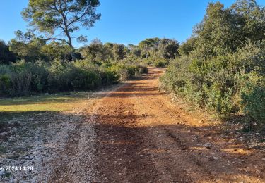
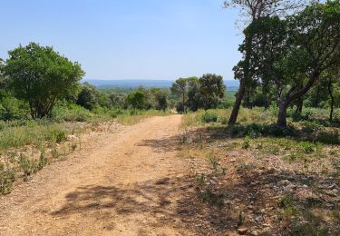
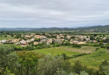
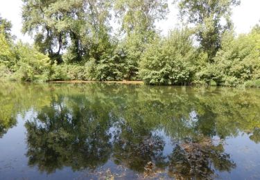
Départ randonnée : Montmirat sur la D6110 entre Sommières et Alès. se garer derrière la mairie rue des écoles. Eviter les périodes de forte chaleur, et les jours de chasse. Depuis le parking prendre la rue de l'ancien four et suivre la trace GPS.La randonnée en majorité sur piste, ne présente pas de difficulté.En suivant la trace, ne pas oublier de faire 3 crochets:- Au niveau du bois de Lens pour découvrir les grottes de Bragassargues- A la sortie de la combe de l'aven pour voir l'Aven de Matelas- Avant le retour sur Montmirat pour admirer les ruines de l'ancienne église de Jouffre.Bonne randonnée
Localización
Comentarios
Excursiones cerca
![Excursión Senderismo Orthoux-Sérignac-Quilhan - Sérignac - les Mazes - Bragassargues - Photo](https://media.geolcdn.com/t/375/260/ext.jpg?maxdim=2&url=https%3A%2F%2Fstatic1.geolcdn.com%2Fsiteimages%2Fupload%2Ffiles%2F1553511878bg_sport_marche.png)
![Senderismo Senderismo](https://static1.geolcdn.com/sitytour/trail-icons/101.png)
Senderismo
![](/images/other/stat-length.png)
![](https://static1.geolcdn.com/siteimages/upload/files/16400158638029165_repeat_loop_refresh_sync_direction_icon.png)
![Excursión Senderismo Vic-le-Fesq - Viclefesc_ND_de_la_combe - Photo](https://media.geolcdn.com/t/375/260/255c5ac9-ddd4-4188-8efc-bd87460b25d5.jpg&format=jpg&maxdim=2)
![Senderismo Senderismo](https://static1.geolcdn.com/sitytour/trail-icons/101.png)
Senderismo
![](/images/other/stat-length.png)
![](https://static1.geolcdn.com/siteimages/upload/files/16400158638029165_repeat_loop_refresh_sync_direction_icon.png)
![Excursión Senderismo Montmirat - Montmirat-les grottes - Photo](https://media.geolcdn.com/t/375/260/cb8675cb-cb9d-463f-8be5-40f2d8d5a71f.jpg&format=jpg&maxdim=2)
![Senderismo Senderismo](https://static1.geolcdn.com/sitytour/trail-icons/101.png)
Senderismo
![](/images/other/stat-length.png)
![](https://static1.geolcdn.com/siteimages/upload/files/16400158638029165_repeat_loop_refresh_sync_direction_icon.png)
![Excursión Senderismo Combas - Combas - Photo](https://media.geolcdn.com/t/375/260/02dbc83b-be1c-4bf6-a717-854391d9e59e.jpg&format=jpg&maxdim=2)
![Senderismo Senderismo](https://static1.geolcdn.com/sitytour/trail-icons/101.png)
![Excursión Senderismo Montmirat - montmirat-Chapelle-grottes - Photo](https://media.geolcdn.com/t/375/260/5531c745-da57-4442-bc46-e7fc789fd541.jpg&format=jpg&maxdim=2)
![Senderismo Senderismo](https://static1.geolcdn.com/sitytour/trail-icons/101.png)
Senderismo
![](/images/other/stat-length.png)
![](https://static1.geolcdn.com/siteimages/upload/files/16400158638029165_repeat_loop_refresh_sync_direction_icon.png)
![Excursión A pie Montmirat - Montmirat-2 - Photo](https://media.geolcdn.com/t/375/260/f40b731a-3854-4e2b-a239-008cef63a6a9.jpg&format=jpg&maxdim=2)
![A pie A pie](https://static1.geolcdn.com/sitytour/trail-icons/100.png)
![Excursión Senderismo Vic-le-Fesq - Vic le Fesc Nd de prime Combe - Photo](https://media.geolcdn.com/t/375/260/840b12a4-b0cf-48bf-85ec-82d58c1dbfba.jpg&format=jpg&maxdim=2)
![Senderismo Senderismo](https://static1.geolcdn.com/sitytour/trail-icons/101.png)
Senderismo
![](/images/other/stat-length.png)
![](https://static1.geolcdn.com/siteimages/upload/files/16400158638029165_repeat_loop_refresh_sync_direction_icon.png)
![Excursión Senderismo Vic-le-Fesq - 30 VIC-LE-FESQ - le VIDOURLE - LECQUES - FONTANES - ND de PRIME COMBE - Photo](https://media.geolcdn.com/t/375/260/ext.jpg?maxdim=2&url=https%3A%2F%2Fservices.sitytrail.com%2FGeolivesWS%2FDownloadMedia.ashx%3FTrailID%3D459675%26Media%3D20150816093235.jpg)
![Senderismo Senderismo](https://static1.geolcdn.com/sitytour/trail-icons/101.png)
Senderismo
![](/images/other/stat-length.png)
![](https://static1.geolcdn.com/siteimages/upload/files/16400158638029165_repeat_loop_refresh_sync_direction_icon.png)
![Excursión Senderismo Vic-le-Fesq - Notre Dame de Prime Combe - Vic le Fesq - Photo](https://media.geolcdn.com/t/375/260/ext.jpg?maxdim=2&url=https%3A%2F%2Fservices.sitytrail.com%2FGeolivesWS%2FDownloadMedia.ashx%3FTrailID%3D318048%26Media%3D17518_6.jpg)
![Senderismo Senderismo](https://static1.geolcdn.com/sitytour/trail-icons/101.png)
Senderismo
![](/images/other/stat-length.png)
![](https://static1.geolcdn.com/siteimages/upload/files/16400158638029165_repeat_loop_refresh_sync_direction_icon.png)
Trop de DFCI