![](/images/other/stat-length.png)
![Excursión Senderismo Sainte-Catherine - St Catherine - Lamure par les Loives - Photo](https://media.geolcdn.com/t/1900/400/ext.pjpeg?maxdim=2&url=https%3A%2F%2Fstatic1.geolcdn.com%2Fsiteimages%2Fupload%2Ffiles%2F1553511878bg_sport_marche.png)
St Catherine - Lamure par les Loives
GRISON-Alain
Usuario
![Longitud](/images/other/stat-length.png)
Longitud
16,4 km
![Altitud máxima](https://static1.geolcdn.com/siteimages/upload/files/1508320355ic_sort_altitude_max_24dp.png)
Altitud máxima
933 m
![Desnivel positivo](https://static1.geolcdn.com/siteimages/upload/files/1508320355ic_sort_den_pos_24dp.png)
Desnivel positivo
443 m
![Km-Effort](/images/other/stat-length.png)
Km-Effort
22 km
![Altitud mínima](https://static1.geolcdn.com/siteimages/upload/files/1508320355ic_sort_altitude_min_24dp.png)
Altitud mínima
682 m
![Desnivel negativo](https://static1.geolcdn.com/siteimages/upload/files/1508320355ic_sort_den_neg_24dp.png)
Desnivel negativo
445 m
![Boucle](https://static1.geolcdn.com/siteimages/upload/files/16400158638029165_repeat_loop_refresh_sync_direction_icon.png)
Boucle
Sí
Fecha de creación :
2020-06-21 12:35:45.33
Última modificación :
2020-06-21 22:24:43.625
![Senderismo](https://static1.geolcdn.com/sitytour/trail-icons/101.png)
4h12
Dificultad : Fácil
![Escanee este código QR para abrir la excursión en la aplicación SityTrail](https://capi.geolives.com/qq0zvz2zws4bq2lad0pu/sitytour/trails/2445905/qr.png?size=200)
Aplicación GPS de excursión GRATIS
A propósito
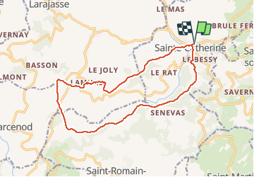
Ruta Senderismo de 16,4 km a descubrir en Auvergne-Rhône-Alpes, Ródano, Sainte-Catherine. Esta ruta ha sido propuesta por GRISON-Alain.
Descripción
Ste Catherine vers Chapelle St Appolinaire
Picnic Lamure et sur GR7
GR7 en partie à l'ombre l'apm.
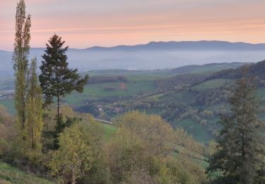
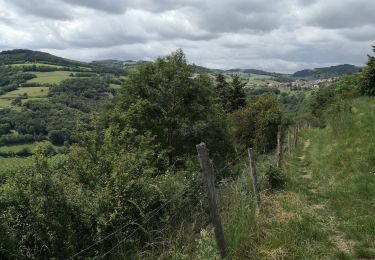
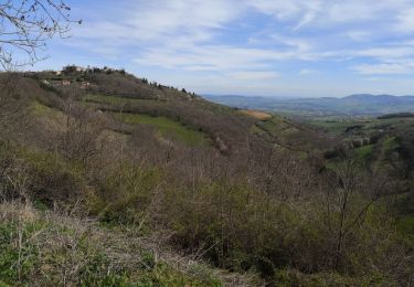
Randonnée très panoramique.
Localización
País:
France
Región :
Auvergne-Rhône-Alpes
Departamento/provincia :
Ródano
Municipio :
Sainte-Catherine
Localidad:
Unknown
Salida:(Dec)
Salida:(UTM)
622573 ; 5050793 (31T) N.
Comentarios
Excursiones cerca
![Excursión Senderismo Sainte-Catherine - ste Catherine le Signal St André - Photo](https://media.geolcdn.com/t/375/260/ext.jpg?maxdim=2&url=https%3A%2F%2Fstatic1.geolcdn.com%2Fsiteimages%2Fupload%2Ffiles%2F1553511878bg_sport_marche.png)
![Senderismo Senderismo](https://static1.geolcdn.com/sitytour/trail-icons/101.png)
ste Catherine le Signal St André
Senderismo
Muy difícil
(1)
Sainte-Catherine,
Auvergne-Rhône-Alpes,
Ródano,
France
![](/images/other/stat-length.png)
16,8 km | 24 km-effort
5h 27min
![](https://static1.geolcdn.com/siteimages/upload/files/16400158638029165_repeat_loop_refresh_sync_direction_icon.png)
Sí
![Excursión Senderismo Saint-Joseph - 42-st-joseph-10km-320m - Photo](https://media.geolcdn.com/t/375/260/d6018596-5a38-4194-9525-041abab6ce05.jpg&format=jpg&maxdim=2)
![Senderismo Senderismo](https://static1.geolcdn.com/sitytour/trail-icons/101.png)
42-st-joseph-10km-320m
Senderismo
Fácil
Saint-Joseph,
Auvergne-Rhône-Alpes,
Loira,
France
![](/images/other/stat-length.png)
10,5 km | 14,8 km-effort
2h 50min
![](https://static1.geolcdn.com/siteimages/upload/files/16400158638029165_repeat_loop_refresh_sync_direction_icon.png)
Sí
![Excursión Senderismo Chabanière - 69-st-maurice-dargoire2-19km-580m - Photo](https://media.geolcdn.com/t/375/260/c4b20fd4-ad58-4836-9971-2020b70efe6f.jpg&format=jpg&maxdim=2)
![Senderismo Senderismo](https://static1.geolcdn.com/sitytour/trail-icons/101.png)
69-st-maurice-dargoire2-19km-580m
Senderismo
Difícil
Chabanière,
Auvergne-Rhône-Alpes,
Ródano,
France
![](/images/other/stat-length.png)
19,2 km | 27 km-effort
5h 47min
![](https://static1.geolcdn.com/siteimages/upload/files/16400158638029165_repeat_loop_refresh_sync_direction_icon.png)
Sí
![Excursión Senderismo Saint-Martin-la-Plaine - 42-martinlaplaine-12km450m - Photo](https://media.geolcdn.com/t/375/260/0bbcbe3d-ff1f-4c48-95ef-874625509cfa.jpg&format=jpg&maxdim=2)
![Senderismo Senderismo](https://static1.geolcdn.com/sitytour/trail-icons/101.png)
42-martinlaplaine-12km450m
Senderismo
Difícil
Saint-Martin-la-Plaine,
Auvergne-Rhône-Alpes,
Loira,
France
![](/images/other/stat-length.png)
12,9 km | 18,9 km-effort
4h 17min
![](https://static1.geolcdn.com/siteimages/upload/files/16400158638029165_repeat_loop_refresh_sync_direction_icon.png)
Sí
![Excursión Senderismo Riverie - Riverie - Tour au dessus de Riverie - Photo](https://media.geolcdn.com/t/375/260/f386fa9b-109a-4f00-b8bc-6419b37fffdc.jpg&format=jpg&maxdim=2)
![Senderismo Senderismo](https://static1.geolcdn.com/sitytour/trail-icons/101.png)
Riverie - Tour au dessus de Riverie
Senderismo
Medio
Riverie,
Auvergne-Rhône-Alpes,
Ródano,
France
![](/images/other/stat-length.png)
5,7 km | 7,8 km-effort
2h 4min
![](https://static1.geolcdn.com/siteimages/upload/files/16400158638029165_repeat_loop_refresh_sync_direction_icon.png)
Sí
![Excursión Senderismo Saint-André-la-Côte - 69-st-andre-la cote-mattiole-20km-640m-mai22 - Photo](https://media.geolcdn.com/t/375/260/7a464e9e-07ad-49d2-9fc0-eab7bce1d3e5.jpg&format=jpg&maxdim=2)
![Senderismo Senderismo](https://static1.geolcdn.com/sitytour/trail-icons/101.png)
69-st-andre-la cote-mattiole-20km-640m-mai22
Senderismo
Medio
Saint-André-la-Côte,
Auvergne-Rhône-Alpes,
Ródano,
France
![](/images/other/stat-length.png)
20 km | 29 km-effort
5h 56min
![](https://static1.geolcdn.com/siteimages/upload/files/16400158638029165_repeat_loop_refresh_sync_direction_icon.png)
Sí
![Excursión Senderismo Saint-André-la-Côte - 69-St-andre-la-cote-Ste-catherine-14km-453m - Photo](https://media.geolcdn.com/t/375/260/06cb0992-8e16-4e77-b851-837722622855.jpg&format=jpg&maxdim=2)
![Senderismo Senderismo](https://static1.geolcdn.com/sitytour/trail-icons/101.png)
69-St-andre-la-cote-Ste-catherine-14km-453m
Senderismo
Medio
Saint-André-la-Côte,
Auvergne-Rhône-Alpes,
Ródano,
France
![](/images/other/stat-length.png)
14,2 km | 20 km-effort
3h 48min
![](https://static1.geolcdn.com/siteimages/upload/files/16400158638029165_repeat_loop_refresh_sync_direction_icon.png)
Sí
![Excursión Senderismo Riverie - Tour de Riverie - Photo](https://media.geolcdn.com/t/375/260/921cac9b-3a26-4e9e-996b-090d375df192.jpg&format=jpg&maxdim=2)
![Senderismo Senderismo](https://static1.geolcdn.com/sitytour/trail-icons/101.png)
Tour de Riverie
Senderismo
Muy fácil
Riverie,
Auvergne-Rhône-Alpes,
Ródano,
France
![](/images/other/stat-length.png)
5,5 km | 8,2 km-effort
3h 1min
![](https://static1.geolcdn.com/siteimages/upload/files/16400158638029165_repeat_loop_refresh_sync_direction_icon.png)
Sí
![Excursión Senderismo Riverie - De Riverie à Sainte Catherine - Photo](https://media.geolcdn.com/t/375/260/c7a98120-57a9-4a3e-a51c-d75d0931a5ce.jpg&format=jpg&maxdim=2)
![Senderismo Senderismo](https://static1.geolcdn.com/sitytour/trail-icons/101.png)
De Riverie à Sainte Catherine
Senderismo
Fácil
Riverie,
Auvergne-Rhône-Alpes,
Ródano,
France
![](/images/other/stat-length.png)
6,3 km | 9,2 km-effort
4h 5min
![](https://static1.geolcdn.com/siteimages/upload/files/16400158638029165_repeat_loop_refresh_sync_direction_icon.png)
Sí