![](/images/other/stat-length.png)
![Excursión Senderismo Chapelle-des-Bois - GR5 Etape 10 - Photo](https://media.geolcdn.com/t/1900/400/ext.pjpeg?maxdim=2&url=https%3A%2F%2Fstatic1.geolcdn.com%2Fsiteimages%2Fupload%2Ffiles%2F1553511878bg_sport_marche.png)
GR5 Etape 10
svp59
Usuario
![Longitud](/images/other/stat-length.png)
Longitud
21 km
![Altitud máxima](https://static1.geolcdn.com/siteimages/upload/files/1508320355ic_sort_altitude_max_24dp.png)
Altitud máxima
1225 m
![Desnivel positivo](https://static1.geolcdn.com/siteimages/upload/files/1508320355ic_sort_den_pos_24dp.png)
Desnivel positivo
315 m
![Km-Effort](/images/other/stat-length.png)
Km-Effort
26 km
![Altitud mínima](https://static1.geolcdn.com/siteimages/upload/files/1508320355ic_sort_altitude_min_24dp.png)
Altitud mínima
933 m
![Desnivel negativo](https://static1.geolcdn.com/siteimages/upload/files/1508320355ic_sort_den_neg_24dp.png)
Desnivel negativo
461 m
![Boucle](https://static1.geolcdn.com/siteimages/upload/files/16400158638029165_repeat_loop_refresh_sync_direction_icon.png)
Boucle
No
Fecha de creación :
2014-12-10 00:00:00.0
Última modificación :
2014-12-10 00:00:00.0
![Senderismo](https://static1.geolcdn.com/sitytour/trail-icons/101.png)
5h33
Dificultad : Medio
![Escanee este código QR para abrir la excursión en la aplicación SityTrail](https://capi.geolives.com/qq0zvz2zws4bq2lad0pu/sitytour/trails/244526/qr.png?size=200)
Aplicación GPS de excursión GRATIS
A propósito
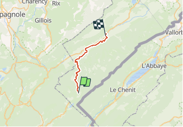
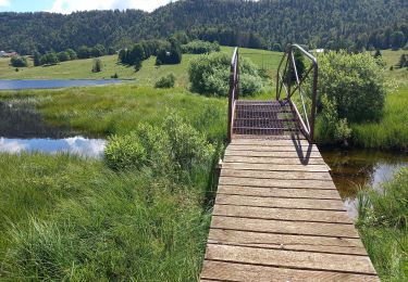
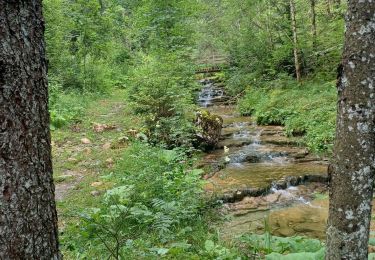
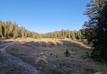
Ruta Senderismo de 21 km a descubrir en Borgoña-Franco Condado, Doubs, Chapelle-des-Bois. Esta ruta ha sido propuesta por svp59.
Descripción
Chapelle des bois Mouthe
GITE ART ET RANDONNEE http://www.jura-gite-vacance.com/
Localización
País:
France
Región :
Borgoña-Franco Condado
Departamento/provincia :
Doubs
Municipio :
Chapelle-des-Bois
Localidad:
Unknown
Salida:(Dec)
Salida:(UTM)
278954 ; 5164626 (32T) N.
Comentarios
Excursiones cerca
![Excursión Senderismo Chapelle-des-Bois - roche Bernard - Photo](https://media.geolcdn.com/t/375/260/ext.jpg?maxdim=2&url=https%3A%2F%2Fservices.sitytrail.com%2FGeolivesWS%2FDownloadMedia.ashx%3FTrailID%3D314677%26Media%3D20140620142657.jpg)
![Senderismo Senderismo](https://static1.geolcdn.com/sitytour/trail-icons/101.png)
roche Bernard
Senderismo
Medio
(1)
Chapelle-des-Bois,
Borgoña-Franco Condado,
Doubs,
France
![](/images/other/stat-length.png)
15 km | 21 km-effort
4h 33min
![](https://static1.geolcdn.com/siteimages/upload/files/16400158638029165_repeat_loop_refresh_sync_direction_icon.png)
Sí
![Excursión Senderismo Chapelle-des-Bois - ROCHE CHAMPION - Photo](https://media.geolcdn.com/t/375/260/ext.jpg?maxdim=2&url=https%3A%2F%2Fservices.sitytrail.com%2FGeolivesWS%2FDownloadMedia.ashx%3FTrailID%3D357205%26Media%3Dfix__20141026130524.jpg)
![Senderismo Senderismo](https://static1.geolcdn.com/sitytour/trail-icons/101.png)
ROCHE CHAMPION
Senderismo
Fácil
(2)
Chapelle-des-Bois,
Borgoña-Franco Condado,
Doubs,
France
![](/images/other/stat-length.png)
8,6 km | 13,6 km-effort
1h 50min
![](https://static1.geolcdn.com/siteimages/upload/files/16400158638029165_repeat_loop_refresh_sync_direction_icon.png)
Sí
![Excursión Senderismo Bellefontaine - Lac de Bellefontaine er lac des Mortes . - Photo](https://media.geolcdn.com/t/375/260/7671d781-54af-47e4-b735-a1a3fd8960ba.jpg&format=jpg&maxdim=2)
![Senderismo Senderismo](https://static1.geolcdn.com/sitytour/trail-icons/101.png)
Lac de Bellefontaine er lac des Mortes .
Senderismo
Fácil
Bellefontaine,
Borgoña-Franco Condado,
Jura,
France
![](/images/other/stat-length.png)
9,5 km | 11,5 km-effort
2h 33min
![](https://static1.geolcdn.com/siteimages/upload/files/16400158638029165_repeat_loop_refresh_sync_direction_icon.png)
Sí
![Excursión Senderismo Chapelle-des-Bois - Roche Champion et Bernard 11.7.24 - Photo](https://media.geolcdn.com/t/375/260/0e6e22cc-0313-48ed-a610-26f870c14444.jpg&format=jpg&maxdim=2)
![Senderismo Senderismo](https://static1.geolcdn.com/sitytour/trail-icons/101.png)
Roche Champion et Bernard 11.7.24
Senderismo
Medio
Chapelle-des-Bois,
Borgoña-Franco Condado,
Doubs,
France
![](/images/other/stat-length.png)
11,5 km | 16,6 km-effort
3h 45min
![](https://static1.geolcdn.com/siteimages/upload/files/16400158638029165_repeat_loop_refresh_sync_direction_icon.png)
Sí
![Excursión Senderismo Bellefontaine - Pichonnier-Peraillet- village par l'Évalude - Photo](https://media.geolcdn.com/t/375/260/a5d97e4a-8813-4957-9f75-ff2855599f4e.jpg&format=jpg&maxdim=2)
![Senderismo Senderismo](https://static1.geolcdn.com/sitytour/trail-icons/101.png)
Pichonnier-Peraillet- village par l'Évalude
Senderismo
Difícil
Bellefontaine,
Borgoña-Franco Condado,
Jura,
France
![](/images/other/stat-length.png)
5,4 km | 7,5 km-effort
1h 53min
![](https://static1.geolcdn.com/siteimages/upload/files/16400158638029165_repeat_loop_refresh_sync_direction_icon.png)
Sí
![Excursión Bicicleta híbrida Chapelle-des-Bois - Risoux - Photo](https://media.geolcdn.com/t/375/260/ext.jpg?maxdim=2&url=https%3A%2F%2Fstatic1.geolcdn.com%2Fsiteimages%2Fupload%2Ffiles%2F1524743154velo.jpg)
![Bicicleta híbrida Bicicleta híbrida](https://static1.geolcdn.com/sitytour/trail-icons/203.png)
Risoux
Bicicleta híbrida
Muy fácil
(1)
Chapelle-des-Bois,
Borgoña-Franco Condado,
Doubs,
France
![](/images/other/stat-length.png)
21 km | 27 km-effort
2h 0min
![](https://static1.geolcdn.com/siteimages/upload/files/16400158638029165_repeat_loop_refresh_sync_direction_icon.png)
No
![Excursión Senderismo Châtelblanc - Le pré-poncet par le petit pont et la forêt - Photo](https://media.geolcdn.com/t/375/260/fcdeff3a-81b6-4364-ba7d-ea1890d5ba3f.jpg&format=jpg&maxdim=2)
![Senderismo Senderismo](https://static1.geolcdn.com/sitytour/trail-icons/101.png)
Le pré-poncet par le petit pont et la forêt
Senderismo
Medio
Châtelblanc,
Borgoña-Franco Condado,
Doubs,
France
![](/images/other/stat-length.png)
5,9 km | 7,7 km-effort
1h 44min
![](https://static1.geolcdn.com/siteimages/upload/files/16400158638029165_repeat_loop_refresh_sync_direction_icon.png)
Sí
![Excursión Raquetas de nieve Chapelle-des-Bois - Chapelle 6.5 km 20240114 - Photo](https://media.geolcdn.com/t/375/260/ext.jpg?maxdim=2&url=https%3A%2F%2Fstatic1.geolcdn.com%2Fsiteimages%2Fupload%2Ffiles%2F1524743153raquette.jpg)
![Raquetas de nieve Raquetas de nieve](https://static1.geolcdn.com/sitytour/trail-icons/504.png)
Chapelle 6.5 km 20240114
Raquetas de nieve
Muy fácil
(1)
Chapelle-des-Bois,
Borgoña-Franco Condado,
Doubs,
France
![](/images/other/stat-length.png)
6,5 km | 8,5 km-effort
1h 36min
![](https://static1.geolcdn.com/siteimages/upload/files/16400158638029165_repeat_loop_refresh_sync_direction_icon.png)
Sí
![Excursión Senderismo Bellefontaine - Des lacs de Bellefontaine vers le belvédère de la roche Bernard. - Photo](https://media.geolcdn.com/t/375/260/4c61fcfd-b428-4bd3-b76a-55bf7607b035.jpg&format=jpg&maxdim=2)
![Senderismo Senderismo](https://static1.geolcdn.com/sitytour/trail-icons/101.png)
Des lacs de Bellefontaine vers le belvédère de la roche Bernard.
Senderismo
Difícil
Bellefontaine,
Borgoña-Franco Condado,
Jura,
France
![](/images/other/stat-length.png)
5,8 km | 8,7 km-effort
1h 53min
![](https://static1.geolcdn.com/siteimages/upload/files/16400158638029165_repeat_loop_refresh_sync_direction_icon.png)
Sí