![](/images/other/stat-length.png)
![Excursión Senderismo Simeyrols - SIMEYROLS - Photo](https://media.geolcdn.com/t/1900/400/ext.pjpeg?maxdim=2&url=https%3A%2F%2Fstatic1.geolcdn.com%2Fsiteimages%2Fupload%2Ffiles%2F1553511878bg_sport_marche.png)
SIMEYROLS
swp648
Usuario
![Longitud](/images/other/stat-length.png)
![Altitud máxima](https://static1.geolcdn.com/siteimages/upload/files/1508320355ic_sort_altitude_max_24dp.png)
![Desnivel positivo](https://static1.geolcdn.com/siteimages/upload/files/1508320355ic_sort_den_pos_24dp.png)
![Km-Effort](/images/other/stat-length.png)
![Altitud mínima](https://static1.geolcdn.com/siteimages/upload/files/1508320355ic_sort_altitude_min_24dp.png)
![Desnivel negativo](https://static1.geolcdn.com/siteimages/upload/files/1508320355ic_sort_den_neg_24dp.png)
![Boucle](https://static1.geolcdn.com/siteimages/upload/files/16400158638029165_repeat_loop_refresh_sync_direction_icon.png)
![Senderismo](https://static1.geolcdn.com/sitytour/trail-icons/101.png)
3h07
Dificultad : Medio
![Escanee este código QR para abrir la excursión en la aplicación SityTrail](https://capi.geolives.com/qq0zvz2zws4bq2lad0pu/sitytour/trails/2444570/qr.png?size=200)
Aplicación GPS de excursión GRATIS
A propósito
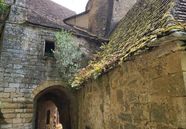
Ruta Senderismo de 12,6 km a descubrir en Nueva Aquitania, Dordogne, Simeyrols. Esta ruta ha sido propuesta por swp648.
Descripción
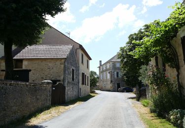
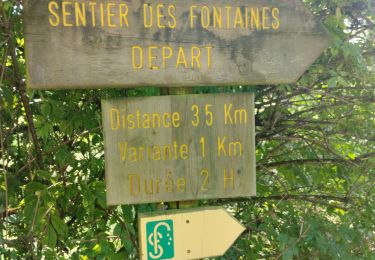
Boucle de Simeyrols autour de Carlux.
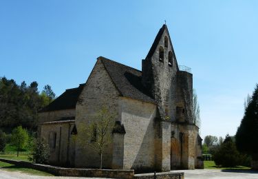
Départ depuis le panneau d'appels qui se trouve sur la D47 au-dessus du cimetière, contourner le, puis diriger vous vers le village. Arrivé à l'église, prendre le sentier sur votre droite.
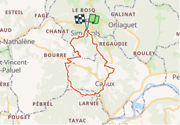
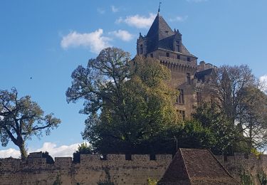
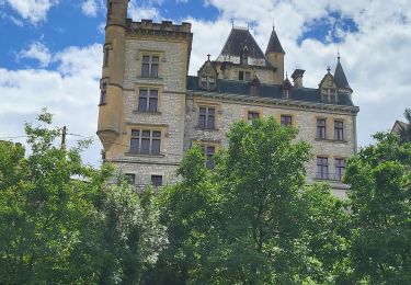
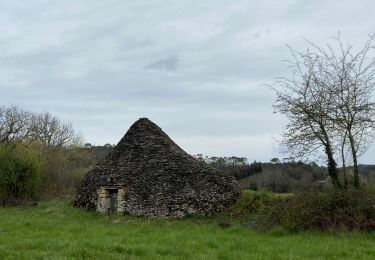
Sur votre chemin, au 8 ème km, prener le temps de flâner dans le magnifique village de Carlux.
Localización
Comentarios
Excursiones cerca
![Excursión Senderismo Saint-Vincent-le-Paluel - Boucle du Paluel - Photo](https://media.geolcdn.com/t/375/260/ext.jpg?maxdim=2&url=https%3A%2F%2Fstatic1.geolcdn.com%2Fsiteimages%2Fupload%2Ffiles%2F1553511878bg_sport_marche.png)
![Senderismo Senderismo](https://static1.geolcdn.com/sitytour/trail-icons/101.png)
Senderismo
![](/images/other/stat-length.png)
![](https://static1.geolcdn.com/siteimages/upload/files/16400158638029165_repeat_loop_refresh_sync_direction_icon.png)
![Excursión Senderismo Saint-Vincent-le-Paluel - Rando Dordogne jour 1 - Photo](https://media.geolcdn.com/t/375/260/cfec1289-9526-4294-b5f6-f93e54f813ee.jpg&format=jpg&maxdim=2)
![Senderismo Senderismo](https://static1.geolcdn.com/sitytour/trail-icons/101.png)
Senderismo
![](/images/other/stat-length.png)
![](https://static1.geolcdn.com/siteimages/upload/files/16400158638029165_repeat_loop_refresh_sync_direction_icon.png)
![Excursión Bici de carretera Calviac-en-Périgord - MARTEL - DE CALVIAC EN PASSANT PAR SOUILLAC - Photo](https://media.geolcdn.com/t/375/260/f8797973-83ed-43e5-8480-f17305a157d8.jpg&format=jpg&maxdim=2)
![Bici de carretera Bici de carretera](https://static1.geolcdn.com/sitytour/trail-icons/201.png)
Bici de carretera
![](/images/other/stat-length.png)
![](https://static1.geolcdn.com/siteimages/upload/files/16400158638029165_repeat_loop_refresh_sync_direction_icon.png)
![Excursión Bici de carretera Calviac-en-Périgord - VALLÉE DE LA DORDOGNE- PARCOURS OUEST DEPUIS CALVIAC EN PÉRIGORD - Photo](https://media.geolcdn.com/t/375/260/76580b75-b307-436a-94dd-ef26172667ba.jpg&format=jpg&maxdim=2)
![Bici de carretera Bici de carretera](https://static1.geolcdn.com/sitytour/trail-icons/201.png)
Bici de carretera
![](/images/other/stat-length.png)
![](https://static1.geolcdn.com/siteimages/upload/files/16400158638029165_repeat_loop_refresh_sync_direction_icon.png)
![Excursión A pie Salignac-Eyvigues - Sentier des Fontaines - Photo](https://media.geolcdn.com/t/375/260/a10682cf-bd62-402c-91c4-a1de293eda80.jpeg&format=jpg&maxdim=2)
![A pie A pie](https://static1.geolcdn.com/sitytour/trail-icons/100.png)
A pie
![](/images/other/stat-length.png)
![](https://static1.geolcdn.com/siteimages/upload/files/16400158638029165_repeat_loop_refresh_sync_direction_icon.png)
![Excursión Senderismo Salignac-Eyvigues - Sentier des Fontaines - Photo](https://media.geolcdn.com/t/375/260/309dcb3c-e1ce-41b6-adfe-f203c4632474.jpg&format=jpg&maxdim=2)
![Senderismo Senderismo](https://static1.geolcdn.com/sitytour/trail-icons/101.png)
Senderismo
![](/images/other/stat-length.png)
![](https://static1.geolcdn.com/siteimages/upload/files/16400158638029165_repeat_loop_refresh_sync_direction_icon.png)
![Excursión Senderismo Saint-Vincent-le-Paluel - SAINT VINCENT LE PALUEL - Photo](https://media.geolcdn.com/t/375/260/f25f2086-e696-49e6-bd0b-5d7a1841fc48.jpg&format=jpg&maxdim=2)
![Senderismo Senderismo](https://static1.geolcdn.com/sitytour/trail-icons/101.png)
Senderismo
![](/images/other/stat-length.png)
![](https://static1.geolcdn.com/siteimages/upload/files/16400158638029165_repeat_loop_refresh_sync_direction_icon.png)
![Excursión Senderismo Saint-Vincent-le-Paluel - Un petit tour avec un château en ruine et une boîte - Photo](https://media.geolcdn.com/t/375/260/dcffb979-dc4e-4b25-87da-f552ef60ae8f.jpg&format=jpg&maxdim=2)
![Senderismo Senderismo](https://static1.geolcdn.com/sitytour/trail-icons/101.png)
Senderismo
![](/images/other/stat-length.png)
![](https://static1.geolcdn.com/siteimages/upload/files/16400158638029165_repeat_loop_refresh_sync_direction_icon.png)
![Excursión A pie Sainte-Nathalène - Sentier du Manoir d'Eyrignac - Photo](https://media.geolcdn.com/t/375/260/5f5a7972-42b3-4517-b8d7-b481567f4d2d.jpeg&format=jpg&maxdim=2)
![A pie A pie](https://static1.geolcdn.com/sitytour/trail-icons/100.png)
A pie
![](/images/other/stat-length.png)
![](https://static1.geolcdn.com/siteimages/upload/files/16400158638029165_repeat_loop_refresh_sync_direction_icon.png)