![](/images/other/stat-length.png)
![Excursión Senderismo Jougne - aiguilles de Baulmes et retour Suchet - Photo](https://media.geolcdn.com/t/1900/400/c17e4977-34fe-43ba-93d4-0a17ab33486a.jpg&format=pjpeg&maxdim=2)
aiguilles de Baulmes et retour Suchet
BM25
Usuario
![Longitud](/images/other/stat-length.png)
![Altitud máxima](https://static1.geolcdn.com/siteimages/upload/files/1508320355ic_sort_altitude_max_24dp.png)
![Desnivel positivo](https://static1.geolcdn.com/siteimages/upload/files/1508320355ic_sort_den_pos_24dp.png)
![Km-Effort](/images/other/stat-length.png)
![Altitud mínima](https://static1.geolcdn.com/siteimages/upload/files/1508320355ic_sort_altitude_min_24dp.png)
![Desnivel negativo](https://static1.geolcdn.com/siteimages/upload/files/1508320355ic_sort_den_neg_24dp.png)
![Boucle](https://static1.geolcdn.com/siteimages/upload/files/16400158638029165_repeat_loop_refresh_sync_direction_icon.png)
![Senderismo](https://static1.geolcdn.com/sitytour/trail-icons/101.png)
6h31
Dificultad : Muy fácil
![Escanee este código QR para abrir la excursión en la aplicación SityTrail](https://capi.geolives.com/qq0zvz2zws4bq2lad0pu/sitytour/trails/2440911/qr.png?size=200)
Aplicación GPS de excursión GRATIS
A propósito
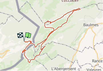
Ruta Senderismo de 23 km a descubrir en Borgoña-Franco Condado, Doubs, Jougne. Esta ruta ha sido propuesta por BM25.
Descripción
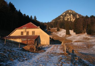
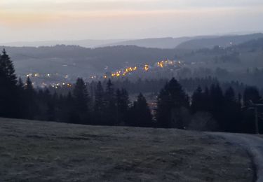
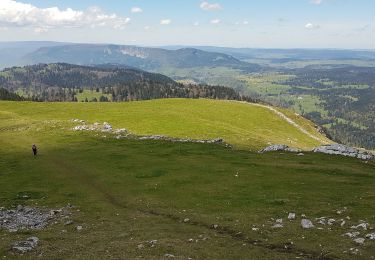
Depuis le refuge de la queue direvtion grange neuve par la roche marquée, puis direction fermes des nas, montée vers les monts de Baulmes, parcours des crêtes jusqu'au sommet des aiguilles de Baulmes, puis descente vers col de l'aiguillon, direction grange neuve et montée au sommet du Suchet..descente vers ferme fe la poyette, retour direction roche marquée et retour au refuge de la queue..
Localización
Comentarios
Excursiones cerca
![Excursión A pie Les Clées - Tourisme pédestre - Photo](https://media.geolcdn.com/t/375/260/69516fc4-f099-4dd3-b5b2-2f14f3d78d3c.jpeg&format=jpg&maxdim=2)
![A pie A pie](https://static1.geolcdn.com/sitytour/trail-icons/100.png)
A pie
![](/images/other/stat-length.png)
![](https://static1.geolcdn.com/siteimages/upload/files/16400158638029165_repeat_loop_refresh_sync_direction_icon.png)
![Excursión A pie Sainte-Croix - La Gittaz-Col de l'Aigullon - Photo](https://media.geolcdn.com/t/375/260/6946b4e0-6068-4cfa-bbe6-24c55651ec09.jpeg&format=jpg&maxdim=2)
![A pie A pie](https://static1.geolcdn.com/sitytour/trail-icons/100.png)
A pie
![](/images/other/stat-length.png)
![](https://static1.geolcdn.com/siteimages/upload/files/16400158638029165_repeat_loop_refresh_sync_direction_icon.png)
![Excursión A pie Sainte-Croix - Sainte Croix-La Gittaz - Photo](https://media.geolcdn.com/t/375/260/7c0dcc60-9777-42cd-b5f3-05d60f03159f.jpeg&format=jpg&maxdim=2)
![A pie A pie](https://static1.geolcdn.com/sitytour/trail-icons/100.png)
A pie
![](/images/other/stat-length.png)
![](https://static1.geolcdn.com/siteimages/upload/files/16400158638029165_repeat_loop_refresh_sync_direction_icon.png)
![Excursión A pie Sainte-Croix - Chemin de la Gare - Photo](https://media.geolcdn.com/t/375/260/1c01c3b8-df2a-4423-9b92-ab96556853c0.jpeg&format=jpg&maxdim=2)
![A pie A pie](https://static1.geolcdn.com/sitytour/trail-icons/100.png)
A pie
![](/images/other/stat-length.png)
![](https://static1.geolcdn.com/siteimages/upload/files/16400158638029165_repeat_loop_refresh_sync_direction_icon.png)
![Excursión Senderismo Jougne - Aiguilles de Baulmes - Suisse - Photo](https://media.geolcdn.com/t/375/260/ext.jpg?maxdim=2&url=https%3A%2F%2Fstatic1.geolcdn.com%2Fsiteimages%2Fupload%2Ffiles%2F1553511878bg_sport_marche.png)
![Senderismo Senderismo](https://static1.geolcdn.com/sitytour/trail-icons/101.png)
Senderismo
![](/images/other/stat-length.png)
![](https://static1.geolcdn.com/siteimages/upload/files/16400158638029165_repeat_loop_refresh_sync_direction_icon.png)
![Excursión A pie Les Fourgs - Le Sentier des Bornes - Photo](https://media.geolcdn.com/t/375/260/4777e0b5-35d9-430b-b18b-01a7bbd1a8dc.jpeg&format=jpg&maxdim=2)
![A pie A pie](https://static1.geolcdn.com/sitytour/trail-icons/100.png)
A pie
![](/images/other/stat-length.png)
![](https://static1.geolcdn.com/siteimages/upload/files/16400158638029165_repeat_loop_refresh_sync_direction_icon.png)
![Excursión Senderismo Jougne - La poyette - Photo](https://media.geolcdn.com/t/375/260/7455827d-3f9e-4079-9524-3e53ae00a5a5.jpg&format=jpg&maxdim=2)
![Senderismo Senderismo](https://static1.geolcdn.com/sitytour/trail-icons/101.png)
Senderismo
![](/images/other/stat-length.png)
![](https://static1.geolcdn.com/siteimages/upload/files/16400158638029165_repeat_loop_refresh_sync_direction_icon.png)
![Excursión Senderismo Jougne - Échappés Cernys - boucle - Photo](https://media.geolcdn.com/t/375/260/ext.jpg?maxdim=2&url=https%3A%2F%2Fservices.sitytrail.com%2FGeolivesWS%2FDownloadMedia.ashx%3FTrailID%3D1005583%26Media%3Dfix__20180716184059.jpg)
![Senderismo Senderismo](https://static1.geolcdn.com/sitytour/trail-icons/101.png)
Senderismo
![](/images/other/stat-length.png)
![](https://static1.geolcdn.com/siteimages/upload/files/16400158638029165_repeat_loop_refresh_sync_direction_icon.png)
![Excursión Senderismo Jougne - Jougne-Le-Suchet - Photo](https://media.geolcdn.com/t/375/260/78012b04-1d56-4360-8011-a370510b5e39.jpg&format=jpg&maxdim=2)
![Senderismo Senderismo](https://static1.geolcdn.com/sitytour/trail-icons/101.png)
Senderismo
![](/images/other/stat-length.png)
![](https://static1.geolcdn.com/siteimages/upload/files/16400158638029165_repeat_loop_refresh_sync_direction_icon.png)