![](/images/other/stat-length.png)
![Excursión Senderismo Bansat - chez achille et rosalie - le tour de bansat - Photo](https://media.geolcdn.com/t/1900/400/8a3e666a-ecd9-4601-ac7f-df56a25b2112.jpg&format=pjpeg&maxdim=2)
chez achille et rosalie - le tour de bansat
Alain Boyer
Usuario
![Longitud](/images/other/stat-length.png)
![Altitud máxima](https://static1.geolcdn.com/siteimages/upload/files/1508320355ic_sort_altitude_max_24dp.png)
![Desnivel positivo](https://static1.geolcdn.com/siteimages/upload/files/1508320355ic_sort_den_pos_24dp.png)
![Km-Effort](/images/other/stat-length.png)
![Altitud mínima](https://static1.geolcdn.com/siteimages/upload/files/1508320355ic_sort_altitude_min_24dp.png)
![Desnivel negativo](https://static1.geolcdn.com/siteimages/upload/files/1508320355ic_sort_den_neg_24dp.png)
![Boucle](https://static1.geolcdn.com/siteimages/upload/files/16400158638029165_repeat_loop_refresh_sync_direction_icon.png)
![Senderismo](https://static1.geolcdn.com/sitytour/trail-icons/101.png)
1h43
Dificultad : Medio
![Escanee este código QR para abrir la excursión en la aplicación SityTrail](https://capi.geolives.com/qq0zvz2zws4bq2lad0pu/sitytour/trails/2439181/qr.png?size=200)
Aplicación GPS de excursión GRATIS
A propósito
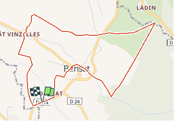
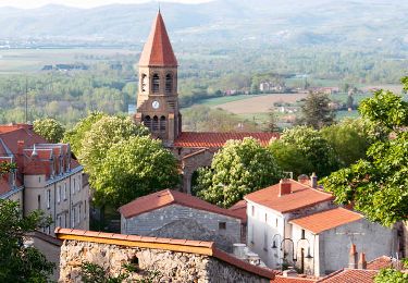
Ruta Senderismo de 6,2 km a descubrir en Auvergne-Rhône-Alpes, Puy-de-Dôme, Bansat. Esta ruta ha sido propuesta por Alain Boyer.
Descripción
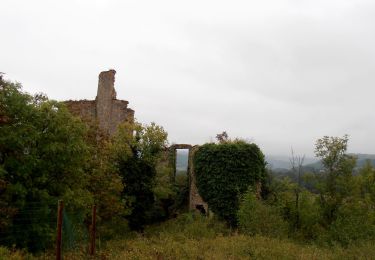
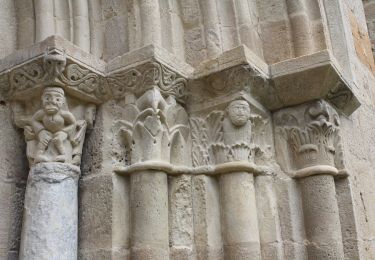
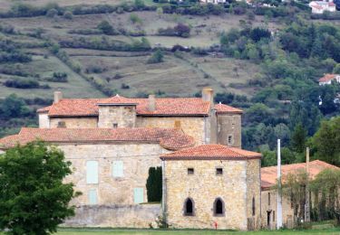
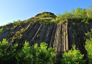
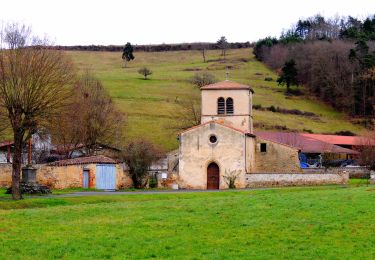
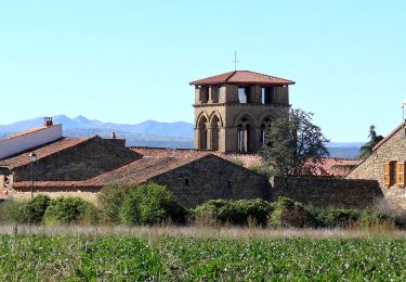
au départ de chez achille et rosalie , direction bansat par l'ancienne route , après la traversée du village de bansat et un aller-retour l'église saint-julien une balade par les vignes et les bois , puis à travers les champs jusqu'à vinzelles et retour à féroussat (attention une montée de 100m dans un chemin en mauvais état au km 1,6)
Localización
Comentarios
Excursiones cerca
![Excursión Senderismo Auzat-la-Combelle - Auzat_Croix - Photo](https://media.geolcdn.com/t/375/260/e2705c59-d58f-4cbd-838f-c8fc6c94cee6.jpg&format=jpg&maxdim=2)
![Senderismo Senderismo](https://static1.geolcdn.com/sitytour/trail-icons/101.png)
Senderismo
![](/images/other/stat-length.png)
![](https://static1.geolcdn.com/siteimages/upload/files/16400158638029165_repeat_loop_refresh_sync_direction_icon.png)
![Excursión Senderismo Les Pradeaux - De l'Allier à l'Ailloux - Photo](https://media.geolcdn.com/t/375/260/ext.jpg?maxdim=2&url=https%3A%2F%2Fservices.sitytrail.com%2FGeolivesWS%2FDownloadMedia.ashx%3FTrailID%3D102201%26Media%3D2601_1.jpg)
![Senderismo Senderismo](https://static1.geolcdn.com/sitytour/trail-icons/101.png)
Senderismo
![](/images/other/stat-length.png)
![](https://static1.geolcdn.com/siteimages/upload/files/16400158638029165_repeat_loop_refresh_sync_direction_icon.png)
![Excursión A pie Esteil - La Croix d'Auzat - Photo](https://media.geolcdn.com/t/375/260/a2a90937-45ee-4416-ac6e-d9a9a8350e15.jpeg&format=jpg&maxdim=2)
![A pie A pie](https://static1.geolcdn.com/sitytour/trail-icons/100.png)
A pie
![](/images/other/stat-length.png)
![](https://static1.geolcdn.com/siteimages/upload/files/16400158638029165_repeat_loop_refresh_sync_direction_icon.png)
![Excursión A pie Lamontgie - Notre-Dame de Mailhat - Photo](https://media.geolcdn.com/t/375/260/8569347c-98a0-4a8f-9e69-27a1e8ebd4a8.jpeg&format=jpg&maxdim=2)
![A pie A pie](https://static1.geolcdn.com/sitytour/trail-icons/100.png)
A pie
![](/images/other/stat-length.png)
![](https://static1.geolcdn.com/siteimages/upload/files/16400158638029165_repeat_loop_refresh_sync_direction_icon.png)
![Excursión A pie Saint-Martin-des-Plains - Vallee de parcelles - Photo](https://media.geolcdn.com/t/375/260/c8678a81-89dc-4bd7-aa82-46bb9b00d226.jpeg&format=jpg&maxdim=2)
![A pie A pie](https://static1.geolcdn.com/sitytour/trail-icons/100.png)
A pie
![](/images/other/stat-length.png)
![](https://static1.geolcdn.com/siteimages/upload/files/16400158638029165_repeat_loop_refresh_sync_direction_icon.png)
![Excursión Senderismo Nonette-Orsonnette - Nonette_Val_Allier - Photo](https://media.geolcdn.com/t/375/260/6af492ac-412f-4f8d-b1d7-92987ee0d659.jpg&format=jpg&maxdim=2)
![Senderismo Senderismo](https://static1.geolcdn.com/sitytour/trail-icons/101.png)
Senderismo
![](/images/other/stat-length.png)
![](https://static1.geolcdn.com/siteimages/upload/files/16400158638029165_repeat_loop_refresh_sync_direction_icon.png)
![Excursión Senderismo Saint-Rémy-de-Chargnat - St_Remy_Pic_Usson - Photo](https://media.geolcdn.com/t/375/260/04fb18f3-77d1-43e8-809b-31619340b4d8.jpg&format=jpg&maxdim=2)
![Senderismo Senderismo](https://static1.geolcdn.com/sitytour/trail-icons/101.png)
Senderismo
![](/images/other/stat-length.png)
![](https://static1.geolcdn.com/siteimages/upload/files/16400158638029165_repeat_loop_refresh_sync_direction_icon.png)
![Excursión Senderismo Saint-Jean-en-Val - St_Jean_Val_Hameaux - Photo](https://media.geolcdn.com/t/375/260/feaea412-b3ae-4fd1-a029-2a33ad18618b.jpg&format=jpg&maxdim=2)
![Senderismo Senderismo](https://static1.geolcdn.com/sitytour/trail-icons/101.png)
Senderismo
![](/images/other/stat-length.png)
![](https://static1.geolcdn.com/siteimages/upload/files/16400158638029165_repeat_loop_refresh_sync_direction_icon.png)
![Senderismo Senderismo](https://static1.geolcdn.com/sitytour/trail-icons/101.png)
Senderismo
![](/images/other/stat-length.png)
![](https://static1.geolcdn.com/siteimages/upload/files/16400158638029165_repeat_loop_refresh_sync_direction_icon.png)