![](/images/other/stat-length.png)
![Excursión Bici de montaña Saint-Paul-Trois-Châteaux - Circuit Rouge n°13 le Val des Nymphes gpx - Photo](https://media.geolcdn.com/t/1900/400/a6ce9a15-3902-4922-b076-6527c920a904.png&format=pjpeg&maxdim=2)
Circuit Rouge n°13 le Val des Nymphes gpx
lespoulpes
Usuario
![Longitud](/images/other/stat-length.png)
![Altitud máxima](https://static1.geolcdn.com/siteimages/upload/files/1508320355ic_sort_altitude_max_24dp.png)
![Desnivel positivo](https://static1.geolcdn.com/siteimages/upload/files/1508320355ic_sort_den_pos_24dp.png)
![Km-Effort](/images/other/stat-length.png)
![Altitud mínima](https://static1.geolcdn.com/siteimages/upload/files/1508320355ic_sort_altitude_min_24dp.png)
![Desnivel negativo](https://static1.geolcdn.com/siteimages/upload/files/1508320355ic_sort_den_neg_24dp.png)
![Boucle](https://static1.geolcdn.com/siteimages/upload/files/16400158638029165_repeat_loop_refresh_sync_direction_icon.png)
![Bici de montaña](https://static1.geolcdn.com/sitytour/trail-icons/202.png)
2h36
Dificultad : Difícil
![Escanee este código QR para abrir la excursión en la aplicación SityTrail](https://capi.geolives.com/qq0zvz2zws4bq2lad0pu/sitytour/trails/2437702/qr.png?size=200)
Aplicación GPS de excursión GRATIS
A propósito
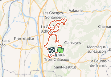
Ruta Bici de montaña de 33 km a descubrir en Auvergne-Rhône-Alpes, Drôme, Saint-Paul-Trois-Châteaux. Esta ruta ha sido propuesta por lespoulpes.
Descripción
13 - DIFFICILE | 33 km | 430 m déniv. | 3h Départ : Saint-Paul-Trois-Châteaux / La Garde-Adhémar
Avec de belles monotraces et de magnifiques points de vue, vous prendrez de la hauteur au village de la Garde-Adhémar. Une visite s’impose au lieu mystérieux du Val des Nymphes. Vous passerez près des caves lapidaires. Au retour, vous emprunterez de beaux sentiers au bord des vignes et vous traverserez la rivière.
Parcours :
DÉPART : Place Chausy (point d’eau). Tourner à droite et suivre le balisage n°13 pour arriver près d’une ferme aux murets en pierre.
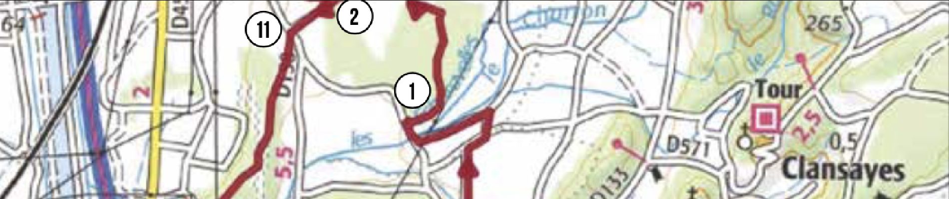
1. S’engager sur un sentier à gauche. Traverser le bois jusqu’à une bifurcation. Tourner à gauche. Plus loin, à droite, rejoindre une route. Tourner à gauche. Attention voitures!
5,6 km
2. Prendre un chemin à droite. Presque tout de suite à gauche, s’engager sur un autre qui se transformera en sentier jusqu’à une piste. Tourner à droite pour rejoindre " Le Rieu " (alt.100 m).
7,6 km
3. Continuer tout droit par une descente et une remontée pavée sur 100 m très raide. En haut, s’engager à droite pour rejoindre une route au poteau " Galerie Linard" (alt.150 m).
9km
4. Tourner à gauche et prendre un chemin à droite. Plus loin à gauche, rejoindre le village de la Garde-Adhémar (point d’eau). Sortir par le porche et arriver aux Rochettes (alt.175 m).
10,5 km
5. Tout droit, suivre un chemin puis, plus loin, tourner à gauche sur une monotrace. Monter un sentier ardu. Arriver sur un chemin, prendre à droite, puis le premier à gauche.
12,9 km
6. Plus haut, s’engager à gauche dans une descente qui rejoint un sentier en sous-bois et une clairière. Remonter puis redescendre une monotrace. Atteindre "Romany " (alt.162 m).
16,7 km
7. Continuer tout droit, puis prendre un sentier à droite qui remontera sur la gauche. Se laisser griser par la vitesse dans cette monotrace. Rejoindre " Les Buissières " (alt.175 m).
19,6 km
8. Descendre la piste pour rejoindre une route au poteau " Val des Nymphes " (alt.155 m). Faire le détour à droite jusqu’à ce lieu magique ! Revenez sur vos pas.
20,8 km
9. Traverser la route et s’engager sur un chemin, puis bifurquer à droite sur une monotrace ludique et joueuse au milieu d’un bois pour rejoindre les " caves Lapidaires " (alt.165 m).
21,5 km
10. Continuer ce sentier qui devient technique (marches, gros cailloux). Descendre la colline, puis rejoindre une route. Tourner à droite jusqu’à un Stop. Attention voitures !
22,6 km
11. S’engager en face sur un chemin. Plus loin, à droite, prendre un sentier dans les bois, puis longer des vignes. Taverser la rivière et rejoindre la voie verte de Saint-Paul-Trois- Châteaux.
24,4 km
12. À " Traverse de Piéjoux " (alt. 83 m), prendre à gauche pour faire le tour du bois, sentier enchanteur ! Revenir sur la voie verte et tourner à gauche pour rejoindre l’arrivée.
30,8 km
ARRIVÉE : Place Chausy (point d’eau).
33 km
Localización
Comentarios
Excursiones cerca
![Excursión Senderismo Clansayes - SityTrail - Clansayes Le Rouvergue 6km - Photo](https://media.geolcdn.com/t/375/260/de3feb6f-5587-4e87-a580-1261cf3df48e.jpg&format=jpg&maxdim=2)
![Senderismo Senderismo](https://static1.geolcdn.com/sitytour/trail-icons/101.png)
Senderismo
![](/images/other/stat-length.png)
![](https://static1.geolcdn.com/siteimages/upload/files/16400158638029165_repeat_loop_refresh_sync_direction_icon.png)
![Excursión Senderismo Saint-Restitut - St Restitut Le Barry 12km - Photo](https://media.geolcdn.com/t/375/260/52d96bcf-650b-4fd0-a59a-69f2b2d3703d.jpg&format=jpg&maxdim=2)
![Senderismo Senderismo](https://static1.geolcdn.com/sitytour/trail-icons/101.png)
Senderismo
![](/images/other/stat-length.png)
![](https://static1.geolcdn.com/siteimages/upload/files/16400158638029165_repeat_loop_refresh_sync_direction_icon.png)
![Excursión Senderismo Bollène - Barry Chabrières Enclume 7,5km - Photo](https://media.geolcdn.com/t/375/260/3a4e67d1-088f-449d-b525-af6a45f2f0d7.jpg&format=jpg&maxdim=2)
![Senderismo Senderismo](https://static1.geolcdn.com/sitytour/trail-icons/101.png)
Senderismo
![](/images/other/stat-length.png)
![](https://static1.geolcdn.com/siteimages/upload/files/16400158638029165_repeat_loop_refresh_sync_direction_icon.png)
![Excursión Senderismo Saint-Restitut - St Restitut Barry 14km - Photo](https://media.geolcdn.com/t/375/260/919620e4-c2f5-475b-864c-8c28884f4028.jpg&format=jpg&maxdim=2)
![Senderismo Senderismo](https://static1.geolcdn.com/sitytour/trail-icons/101.png)
Senderismo
![](/images/other/stat-length.png)
![](https://static1.geolcdn.com/siteimages/upload/files/16400158638029165_repeat_loop_refresh_sync_direction_icon.png)
![Excursión Senderismo Saint-Restitut - Les carrières de Sainte Juste - Saint Restitut - Photo](https://media.geolcdn.com/t/375/260/ext.jpg?maxdim=2&url=https%3A%2F%2Fservices.sitytrail.com%2FGeolivesWS%2FDownloadMedia.ashx%3FTrailID%3D317462%26Media%3D16693_6.jpg)
![Senderismo Senderismo](https://static1.geolcdn.com/sitytour/trail-icons/101.png)
Senderismo
![](/images/other/stat-length.png)
![](https://static1.geolcdn.com/siteimages/upload/files/16400158638029165_repeat_loop_refresh_sync_direction_icon.png)
![Excursión Senderismo Suze-la-Rousse - soleirieu - Photo](https://media.geolcdn.com/t/375/260/ext.jpg?maxdim=2&url=https%3A%2F%2Fstatic1.geolcdn.com%2Fsiteimages%2Fupload%2Ffiles%2F1553511878bg_sport_marche.png)
![Senderismo Senderismo](https://static1.geolcdn.com/sitytour/trail-icons/101.png)
Senderismo
![](/images/other/stat-length.png)
![](https://static1.geolcdn.com/siteimages/upload/files/16400158638029165_repeat_loop_refresh_sync_direction_icon.png)
![Excursión Senderismo Clansayes - 2022-06-24_19h24m07_Clansayes Le Rouvergue 11km.gpx.xml - Photo](https://media.geolcdn.com/t/375/260/89c952dc-9c57-4311-93c9-63263f0349ef.jpg&format=jpg&maxdim=2)
![Senderismo Senderismo](https://static1.geolcdn.com/sitytour/trail-icons/101.png)
Senderismo
![](/images/other/stat-length.png)
![](https://static1.geolcdn.com/siteimages/upload/files/16400158638029165_repeat_loop_refresh_sync_direction_icon.png)
![Excursión Senderismo Clansayes - 2022-05-26_08h43m46_Clansayes Le Rouvergue 8km.gpx.xml - Photo](https://media.geolcdn.com/t/375/260/00183d4b-7799-462e-b9b9-5e3d9f7cb776.jpg&format=jpg&maxdim=2)
![Senderismo Senderismo](https://static1.geolcdn.com/sitytour/trail-icons/101.png)
Senderismo
![](/images/other/stat-length.png)
![](https://static1.geolcdn.com/siteimages/upload/files/16400158638029165_repeat_loop_refresh_sync_direction_icon.png)
![Excursión Senderismo Clansayes - SityTrail - 2656269 - chantemerle-clansayes-15km - Photo](https://media.geolcdn.com/t/375/260/10944c4f-f60a-41d6-ab1f-e2a3431a6612.jpg&format=jpg&maxdim=2)
![Senderismo Senderismo](https://static1.geolcdn.com/sitytour/trail-icons/101.png)
Senderismo
![](/images/other/stat-length.png)
![](https://static1.geolcdn.com/siteimages/upload/files/16400158638029165_repeat_loop_refresh_sync_direction_icon.png)