![](/images/other/stat-length.png)
![Excursión Bici de montaña Saint-Paul-Trois-Châteaux - Circuit Rouge n°9 les Carrières de Ste Juste - Photo](https://media.geolcdn.com/t/1900/400/31a25062-dff7-4dbb-8118-115dc6d62169.png&format=pjpeg&maxdim=2)
Circuit Rouge n°9 les Carrières de Ste Juste
lespoulpes
Usuario
![Longitud](/images/other/stat-length.png)
![Altitud máxima](https://static1.geolcdn.com/siteimages/upload/files/1508320355ic_sort_altitude_max_24dp.png)
![Desnivel positivo](https://static1.geolcdn.com/siteimages/upload/files/1508320355ic_sort_den_pos_24dp.png)
![Km-Effort](/images/other/stat-length.png)
![Altitud mínima](https://static1.geolcdn.com/siteimages/upload/files/1508320355ic_sort_altitude_min_24dp.png)
![Desnivel negativo](https://static1.geolcdn.com/siteimages/upload/files/1508320355ic_sort_den_neg_24dp.png)
![Boucle](https://static1.geolcdn.com/siteimages/upload/files/16400158638029165_repeat_loop_refresh_sync_direction_icon.png)
![Bici de montaña](https://static1.geolcdn.com/sitytour/trail-icons/202.png)
2h11
Dificultad : Difícil
![Escanee este código QR para abrir la excursión en la aplicación SityTrail](https://capi.geolives.com/qq0zvz2zws4bq2lad0pu/sitytour/trails/2437659/qr.png?size=200)
Aplicación GPS de excursión GRATIS
A propósito
Ruta Bici de montaña de 27 km a descubrir en Auvergne-Rhône-Alpes, Drôme, Saint-Paul-Trois-Châteaux. Esta ruta ha sido propuesta por lespoulpes.
Descripción
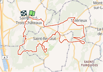
9 - DIFFICILE | 27 km | 380 m déniv. | 2h30 Départ : Saint-Paul-Trois-Châteaux / Saint-Restitut
Ce circuit vous emmène à la découverte de l’étang Saint-Louis, à sec mais avec une végétation luxuriante. Les difficultés commenceront avec une montée pour atteindre le plateau de Saint-Restitut et des sentiers en sous-bois.Vous passerez aux caves cathédrales, puis aux carrières de Sainte-Juste avant de vous engager dans une monotrace sur la dernière descente pour rejoindre Saint-Paul-Trois- Châteaux... vertigineuse !
Parcours :
DÉPART : Place Chausy (point d’eau). Tourner à droite et suivre le balisage n°9 pour sortir du bourg par de petites ruelles. Continuer par une petite route plein Est.
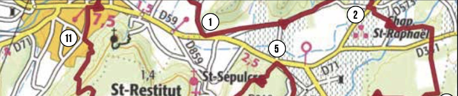
1. Tourner à gauche sur un chemin. Plus loin, sur la gauche, suivre un sentier très ludique en sous-bois. Un chemin à droite mène à la D71. Attention voitures !
2,5 km
2. Traverser la route, prendre un sentier, puis suivre un chemin à droite. Suivre le balisage qui mène à travers vignes et chênes truffiers à une route. Traverser et rejoindre un chemin parfois caillouteux.
6,2 km
3. Tourner à droite sur une ancienne voie romaine, puis à un cairn, bifurquer à gauche sur une monotrace ludique et étroite jusqu'au point de vue sur l’étang Saint-Louis. Plus bas, suivre à droite un chemin large qui rejoint la D59. Attention voitures !
8,5 km
4. Continuer sur la route (plus de 500 m), puis à gauche un chemin. Plus loin, prendre à droite un pont jusqu'à une monotrace sur votre gauche. Traverser une route. Attention voitures !
12,3 km
5. Monter à gauche sur un beau chemin parfois technique dû aux marches naturelles. Atteindre une petite route et s’engager sur un autre sentier. Traverser plus loin un lotissement et rejoindre une route par une belle monotrace.
14,9 km
6. Au carrefour, tourner à gauche, puis à nouveau à gauche pour rejoindre plus loin une grosse bâtisse et un chemin devenant montant et caillouteux.
19,5 km
7. À une intersection, prendre le chemin de droite et monter sur un sentier technique par endroits. En haut, poursuivre à droite sur une monotrace enchanteresse en sous-bois.
20,5 km
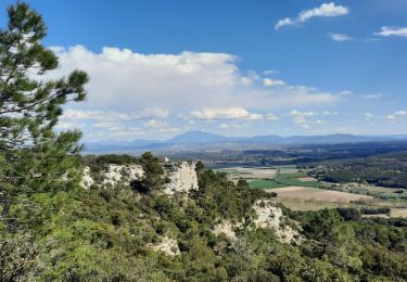
8. Couper le GR après quelques descentes caillouteuses, s'ensuit une portion technique dans les dalles de pierre et une montée ardue près des ruines du Château de Barry.
22,4 km
9. Prendre le temps d’explorer " les Caves cathédrales " et continuer la route pour s’engager sur un chemin à gauche et rejoindre les Carrières de Saint-Juste.
23,6 km
10. À gauche, emprunter un sentier à travers bois. Prendre une descente raide et technique (racines et pierres). En bas, tourner à droite sous un pont et continuer sur un sentier en forêt.
24,5 km
11. Prendre à droite et continuer tout droit jusqu’à un croisement. Tourner à droite, puis plus loin sur votre gauche, longer la piscine.
26,3 km
ARRIVÉE : Place Chausy (point d’eau).
27 km
Localización
Comentarios
Excursiones cerca
![Excursión Senderismo Clansayes - SityTrail - Clansayes Le Rouvergue 6km - Photo](https://media.geolcdn.com/t/375/260/de3feb6f-5587-4e87-a580-1261cf3df48e.jpg&format=jpg&maxdim=2)
![Senderismo Senderismo](https://static1.geolcdn.com/sitytour/trail-icons/101.png)
Senderismo
![](/images/other/stat-length.png)
![](https://static1.geolcdn.com/siteimages/upload/files/16400158638029165_repeat_loop_refresh_sync_direction_icon.png)
![Excursión Senderismo Saint-Restitut - St Restitut Le Barry 12km - Photo](https://media.geolcdn.com/t/375/260/52d96bcf-650b-4fd0-a59a-69f2b2d3703d.jpg&format=jpg&maxdim=2)
![Senderismo Senderismo](https://static1.geolcdn.com/sitytour/trail-icons/101.png)
Senderismo
![](/images/other/stat-length.png)
![](https://static1.geolcdn.com/siteimages/upload/files/16400158638029165_repeat_loop_refresh_sync_direction_icon.png)
![Excursión Senderismo Bollène - Barry Chabrières Enclume 7,5km - Photo](https://media.geolcdn.com/t/375/260/3a4e67d1-088f-449d-b525-af6a45f2f0d7.jpg&format=jpg&maxdim=2)
![Senderismo Senderismo](https://static1.geolcdn.com/sitytour/trail-icons/101.png)
Senderismo
![](/images/other/stat-length.png)
![](https://static1.geolcdn.com/siteimages/upload/files/16400158638029165_repeat_loop_refresh_sync_direction_icon.png)
![Excursión Senderismo Saint-Restitut - St Restitut Barry 14km - Photo](https://media.geolcdn.com/t/375/260/919620e4-c2f5-475b-864c-8c28884f4028.jpg&format=jpg&maxdim=2)
![Senderismo Senderismo](https://static1.geolcdn.com/sitytour/trail-icons/101.png)
Senderismo
![](/images/other/stat-length.png)
![](https://static1.geolcdn.com/siteimages/upload/files/16400158638029165_repeat_loop_refresh_sync_direction_icon.png)
![Excursión Senderismo Saint-Restitut - Les carrières de Sainte Juste - Saint Restitut - Photo](https://media.geolcdn.com/t/375/260/ext.jpg?maxdim=2&url=https%3A%2F%2Fservices.sitytrail.com%2FGeolivesWS%2FDownloadMedia.ashx%3FTrailID%3D317462%26Media%3D16693_6.jpg)
![Senderismo Senderismo](https://static1.geolcdn.com/sitytour/trail-icons/101.png)
Senderismo
![](/images/other/stat-length.png)
![](https://static1.geolcdn.com/siteimages/upload/files/16400158638029165_repeat_loop_refresh_sync_direction_icon.png)
![Excursión Senderismo Suze-la-Rousse - soleirieu - Photo](https://media.geolcdn.com/t/375/260/ext.jpg?maxdim=2&url=https%3A%2F%2Fstatic1.geolcdn.com%2Fsiteimages%2Fupload%2Ffiles%2F1553511878bg_sport_marche.png)
![Senderismo Senderismo](https://static1.geolcdn.com/sitytour/trail-icons/101.png)
Senderismo
![](/images/other/stat-length.png)
![](https://static1.geolcdn.com/siteimages/upload/files/16400158638029165_repeat_loop_refresh_sync_direction_icon.png)
![Excursión Senderismo Clansayes - 2022-06-24_19h24m07_Clansayes Le Rouvergue 11km.gpx.xml - Photo](https://media.geolcdn.com/t/375/260/89c952dc-9c57-4311-93c9-63263f0349ef.jpg&format=jpg&maxdim=2)
![Senderismo Senderismo](https://static1.geolcdn.com/sitytour/trail-icons/101.png)
Senderismo
![](/images/other/stat-length.png)
![](https://static1.geolcdn.com/siteimages/upload/files/16400158638029165_repeat_loop_refresh_sync_direction_icon.png)
![Excursión Senderismo Clansayes - 2022-05-26_08h43m46_Clansayes Le Rouvergue 8km.gpx.xml - Photo](https://media.geolcdn.com/t/375/260/00183d4b-7799-462e-b9b9-5e3d9f7cb776.jpg&format=jpg&maxdim=2)
![Senderismo Senderismo](https://static1.geolcdn.com/sitytour/trail-icons/101.png)
Senderismo
![](/images/other/stat-length.png)
![](https://static1.geolcdn.com/siteimages/upload/files/16400158638029165_repeat_loop_refresh_sync_direction_icon.png)
![Excursión Senderismo Clansayes - SityTrail - 2656269 - chantemerle-clansayes-15km - Photo](https://media.geolcdn.com/t/375/260/10944c4f-f60a-41d6-ab1f-e2a3431a6612.jpg&format=jpg&maxdim=2)
![Senderismo Senderismo](https://static1.geolcdn.com/sitytour/trail-icons/101.png)
Senderismo
![](/images/other/stat-length.png)
![](https://static1.geolcdn.com/siteimages/upload/files/16400158638029165_repeat_loop_refresh_sync_direction_icon.png)