![](/images/other/stat-length.png)
![Excursión Bici de montaña Saint-Restitut - Circuit Rouge n°8 les Caves Cathédrales - Photo](https://media.geolcdn.com/t/1900/400/034d0e16-bd01-4872-beb9-fe14ef3bbebd.png&format=pjpeg&maxdim=2)
Circuit Rouge n°8 les Caves Cathédrales
lespoulpes
Usuario
![Longitud](/images/other/stat-length.png)
![Altitud máxima](https://static1.geolcdn.com/siteimages/upload/files/1508320355ic_sort_altitude_max_24dp.png)
![Desnivel positivo](https://static1.geolcdn.com/siteimages/upload/files/1508320355ic_sort_den_pos_24dp.png)
![Km-Effort](/images/other/stat-length.png)
![Altitud mínima](https://static1.geolcdn.com/siteimages/upload/files/1508320355ic_sort_altitude_min_24dp.png)
![Desnivel negativo](https://static1.geolcdn.com/siteimages/upload/files/1508320355ic_sort_den_neg_24dp.png)
![Boucle](https://static1.geolcdn.com/siteimages/upload/files/16400158638029165_repeat_loop_refresh_sync_direction_icon.png)
![Bici de montaña](https://static1.geolcdn.com/sitytour/trail-icons/202.png)
1h14
Dificultad : Difícil
![Escanee este código QR para abrir la excursión en la aplicación SityTrail](https://capi.geolives.com/qq0zvz2zws4bq2lad0pu/sitytour/trails/2437654/qr.png?size=200)
Aplicación GPS de excursión GRATIS
A propósito
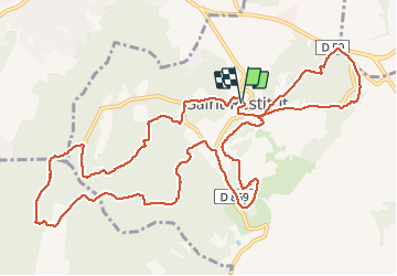
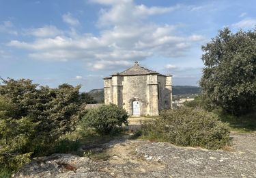
Ruta Bici de montaña de 14,9 km a descubrir en Auvergne-Rhône-Alpes, Drôme, Saint-Restitut. Esta ruta ha sido propuesta por lespoulpes.
Descripción
8 - DIFFICILE | 15 km | 290 m déniv. | 1h30 Départ : Saint-Restitut
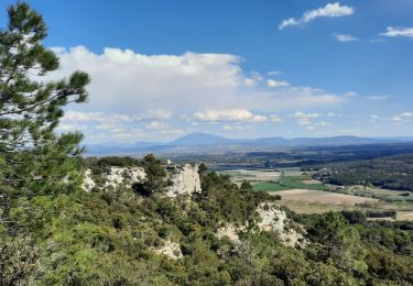
Réservé à un public averti, ce circuit réserve de nombreuses sections techniques et cahotiques. Après une première partie difficile, vous partirez à la découverte du plateau de Saint-Réstitut, de ses sentiers ludiques et techniques à souhait, et du lieu insolite des " caves cathédrales ". Une descente rapide entre les chênes vous reconduira au village. Prudence !
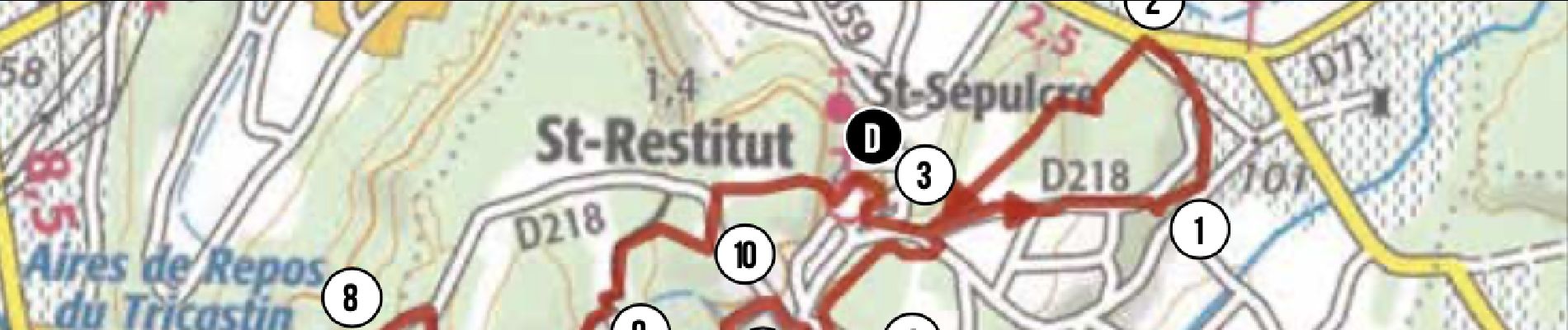
Parcours :
DÉPART : Place du village (point d’eau) passer au lavoir (alt.160 m). Suivre le balisage n°8. Passer un rond-point, prendre la 2e sortie. Plus bas, s'engager à droite sur un chemin descendant qui devient étroit et pentu.
1. Rejoindre une petite route, puis de suite à gauche, prendre un sentier ludique en sous- bois. Déboucher sur la D218 et s'engager en face sur une voie sans issue. Attention voitures !
1,8 km
2. Tourner à gauche et emprunter une longue montée assez difficile (pente et présence de pierres et de marches naturelles).
2,5 km
3. En haut de la côte, tourner à droite, puis à gauche, et à nouveau à droite pour prendre le sentier " des pieux" au profil montant et technique. En haut, suivre la route à gauche.
3,9 km
4. S'engager à droite sur un chemin au milieu des maisons. Suivre le balisage n°8 qui mène sur une monotrace virevoltant dans une belle pinède pour rejoindre une route. Attention voitures !
5,1 km
5. Au carrefour, tourner à gauche, puis à nouveau à gauche pour rejoindre plus loin une grosse bâtisse et un chemin devenant montant et caillouteux.
7km
6. À une intersection, prendre le chemin de droite et continuer à monter sur un sentier technique par endroits. En haut, poursuivre à droite sur une monotrace enchanteresse en sous-bois.
8,2 km
7. Couper le GR après quelques descentes caillouteuses. Continuer sur une portion technique dans les dalles de pierre et une montée ardue près des ruines du Château de Barry.
10,1 km
8. Aux " Caves cathédrales", où une visite s'impose, continuer sur la route et plus loin bifurquer à droite sur un chemin qui deviendra une belle descente, parfois technique, au milieu des chênes verts.
11,3 km
9. Plus bas à une intersection, prendre le sentier sur la gauche qui débouche plus loin sur une petite route.
13 km
10. Tourner à gauche. Atteindre et remonter la D218. Tourner à droite dans un virage pour redescendre à Saint-Restitut par un sentier parfois cahotique. Attention voitures !
13,8 km
ARRIVÉE : Place du village (point d’eau).
15 km
Localización
Comentarios
Excursiones cerca
![Excursión Senderismo Saint-Restitut - St Restitut Le Barry 12km - Photo](https://media.geolcdn.com/t/375/260/52d96bcf-650b-4fd0-a59a-69f2b2d3703d.jpg&format=jpg&maxdim=2)
![Senderismo Senderismo](https://static1.geolcdn.com/sitytour/trail-icons/101.png)
Senderismo
![](/images/other/stat-length.png)
![](https://static1.geolcdn.com/siteimages/upload/files/16400158638029165_repeat_loop_refresh_sync_direction_icon.png)
![Excursión Senderismo Bollène - Barry Chabrières Enclume 7,5km - Photo](https://media.geolcdn.com/t/375/260/3a4e67d1-088f-449d-b525-af6a45f2f0d7.jpg&format=jpg&maxdim=2)
![Senderismo Senderismo](https://static1.geolcdn.com/sitytour/trail-icons/101.png)
Senderismo
![](/images/other/stat-length.png)
![](https://static1.geolcdn.com/siteimages/upload/files/16400158638029165_repeat_loop_refresh_sync_direction_icon.png)
![Excursión Senderismo Saint-Restitut - St Restitut Barry 14km - Photo](https://media.geolcdn.com/t/375/260/919620e4-c2f5-475b-864c-8c28884f4028.jpg&format=jpg&maxdim=2)
![Senderismo Senderismo](https://static1.geolcdn.com/sitytour/trail-icons/101.png)
Senderismo
![](/images/other/stat-length.png)
![](https://static1.geolcdn.com/siteimages/upload/files/16400158638029165_repeat_loop_refresh_sync_direction_icon.png)
![Excursión Senderismo Saint-Restitut - Les carrières de Sainte Juste - Saint Restitut - Photo](https://media.geolcdn.com/t/375/260/ext.jpg?maxdim=2&url=https%3A%2F%2Fservices.sitytrail.com%2FGeolivesWS%2FDownloadMedia.ashx%3FTrailID%3D317462%26Media%3D16693_6.jpg)
![Senderismo Senderismo](https://static1.geolcdn.com/sitytour/trail-icons/101.png)
Senderismo
![](/images/other/stat-length.png)
![](https://static1.geolcdn.com/siteimages/upload/files/16400158638029165_repeat_loop_refresh_sync_direction_icon.png)
![Excursión Senderismo Suze-la-Rousse - soleirieu - Photo](https://media.geolcdn.com/t/375/260/ext.jpg?maxdim=2&url=https%3A%2F%2Fstatic1.geolcdn.com%2Fsiteimages%2Fupload%2Ffiles%2F1553511878bg_sport_marche.png)
![Senderismo Senderismo](https://static1.geolcdn.com/sitytour/trail-icons/101.png)
Senderismo
![](/images/other/stat-length.png)
![](https://static1.geolcdn.com/siteimages/upload/files/16400158638029165_repeat_loop_refresh_sync_direction_icon.png)
![Excursión Senderismo Clansayes - 2022-06-24_19h24m07_Clansayes Le Rouvergue 11km.gpx.xml - Photo](https://media.geolcdn.com/t/375/260/89c952dc-9c57-4311-93c9-63263f0349ef.jpg&format=jpg&maxdim=2)
![Senderismo Senderismo](https://static1.geolcdn.com/sitytour/trail-icons/101.png)
Senderismo
![](/images/other/stat-length.png)
![](https://static1.geolcdn.com/siteimages/upload/files/16400158638029165_repeat_loop_refresh_sync_direction_icon.png)
![Excursión Senderismo Clansayes - SityTrail - 2656269 - chantemerle-clansayes-15km - Photo](https://media.geolcdn.com/t/375/260/10944c4f-f60a-41d6-ab1f-e2a3431a6612.jpg&format=jpg&maxdim=2)
![Senderismo Senderismo](https://static1.geolcdn.com/sitytour/trail-icons/101.png)
Senderismo
![](/images/other/stat-length.png)
![](https://static1.geolcdn.com/siteimages/upload/files/16400158638029165_repeat_loop_refresh_sync_direction_icon.png)
![Excursión Bici de montaña Saint-Paul-Trois-Châteaux - circuit_rouge_no13_le_val_des_nymphes-2 - Photo](https://media.geolcdn.com/t/375/260/ext.jpg?maxdim=2&url=https%3A%2F%2Fstatic1.geolcdn.com%2Fsiteimages%2Fupload%2Ffiles%2F1524743154velo.jpg)
![Bici de montaña Bici de montaña](https://static1.geolcdn.com/sitytour/trail-icons/202.png)
Bici de montaña
![](/images/other/stat-length.png)
![](https://static1.geolcdn.com/siteimages/upload/files/16400158638029165_repeat_loop_refresh_sync_direction_icon.png)
![Excursión sport Saint-Restitut - St Restitut, Chabrieres, le Barry - Photo](https://media.geolcdn.com/t/375/260/63f81cb4-71f2-48a1-8bc8-eca4d8bcd53b.jpg&format=jpg&maxdim=2)
sport
![](/images/other/stat-length.png)
![](https://static1.geolcdn.com/siteimages/upload/files/16400158638029165_repeat_loop_refresh_sync_direction_icon.png)