![](/images/other/stat-length.png)
![Excursión Senderismo Yzeron - Izeron - Des cascades à la Madonne - Photo](https://media.geolcdn.com/t/1900/400/308041cb-9d39-412d-a6ff-b34a3371db68.jpg&format=pjpeg&maxdim=2)
Izeron - Des cascades à la Madonne
Sigmut
Usuario
![Longitud](/images/other/stat-length.png)
Longitud
7,1 km
![Altitud máxima](https://static1.geolcdn.com/siteimages/upload/files/1508320355ic_sort_altitude_max_24dp.png)
Altitud máxima
858 m
![Desnivel positivo](https://static1.geolcdn.com/siteimages/upload/files/1508320355ic_sort_den_pos_24dp.png)
Desnivel positivo
276 m
![Km-Effort](/images/other/stat-length.png)
Km-Effort
10,8 km
![Altitud mínima](https://static1.geolcdn.com/siteimages/upload/files/1508320355ic_sort_altitude_min_24dp.png)
Altitud mínima
611 m
![Desnivel negativo](https://static1.geolcdn.com/siteimages/upload/files/1508320355ic_sort_den_neg_24dp.png)
Desnivel negativo
276 m
![Boucle](https://static1.geolcdn.com/siteimages/upload/files/16400158638029165_repeat_loop_refresh_sync_direction_icon.png)
Boucle
Sí
Fecha de creación :
2020-06-14 11:28:32.967
Última modificación :
2020-07-30 21:33:11.213
![Senderismo](https://static1.geolcdn.com/sitytour/trail-icons/101.png)
3h33
Dificultad : Fácil
![Escanee este código QR para abrir la excursión en la aplicación SityTrail](https://capi.geolives.com/qq0zvz2zws4bq2lad0pu/sitytour/trails/2436225/qr.png?size=200)
Aplicación GPS de excursión GRATIS
A propósito
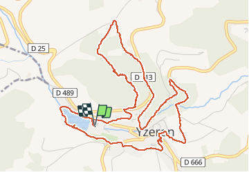
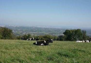
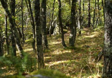
Ruta Senderismo de 7,1 km a descubrir en Auvergne-Rhône-Alpes, Ródano, Yzeron. Esta ruta ha sido propuesta por Sigmut.
Descripción
Rando variée belle et agréable avec un enfant de 3 ans et un autre de 5 ans
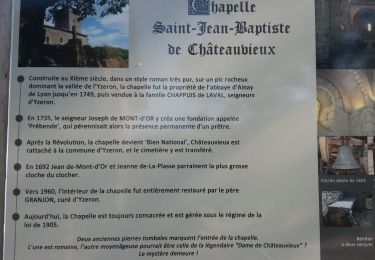
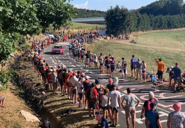
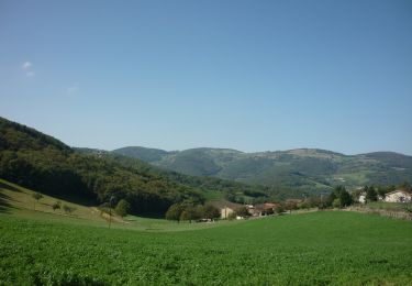
Localización
País:
France
Región :
Auvergne-Rhône-Alpes
Departamento/provincia :
Ródano
Municipio :
Yzeron
Localidad:
Unknown
Salida:(Dec)
Salida:(UTM)
623229 ; 5062857 (31T) N.
Comentarios
Excursiones cerca
![Excursión Senderismo Thurins - tour du bois du baron - Photo](https://media.geolcdn.com/t/375/260/ext.jpg?maxdim=2&url=https%3A%2F%2Fservices.sitytrail.com%2FGeolivesWS%2FDownloadMedia.ashx%3FTrailID%3D548394%26Media%3Dfix__20160403153341.jpg)
![Senderismo Senderismo](https://static1.geolcdn.com/sitytour/trail-icons/101.png)
tour du bois du baron
Senderismo
Fácil
(3)
Thurins,
Auvergne-Rhône-Alpes,
Ródano,
France
![](/images/other/stat-length.png)
7,4 km | 11,5 km-effort
1h 40min
![](https://static1.geolcdn.com/siteimages/upload/files/16400158638029165_repeat_loop_refresh_sync_direction_icon.png)
Sí
![Excursión Senderismo Duerne - Randonnée des collines autour de Duerne - Photo](https://media.geolcdn.com/t/375/260/56b3b5ff-8854-42cb-926b-a132b104089d.jpg&format=jpg&maxdim=2)
![Senderismo Senderismo](https://static1.geolcdn.com/sitytour/trail-icons/101.png)
Randonnée des collines autour de Duerne
Senderismo
Medio
Duerne,
Auvergne-Rhône-Alpes,
Ródano,
France
![](/images/other/stat-length.png)
15,5 km | 22 km-effort
4h 2min
![](https://static1.geolcdn.com/siteimages/upload/files/16400158638029165_repeat_loop_refresh_sync_direction_icon.png)
Sí
![Excursión Senderismo Courzieu - 2023-05-11_18h58m29_Fiche Verte n°5_Courzieu - Photo](https://media.geolcdn.com/t/375/260/ext.jpg?maxdim=2&url=https%3A%2F%2Fstatic1.geolcdn.com%2Fsiteimages%2Fupload%2Ffiles%2F1553511878bg_sport_marche.png)
![Senderismo Senderismo](https://static1.geolcdn.com/sitytour/trail-icons/101.png)
2023-05-11_18h58m29_Fiche Verte n°5_Courzieu
Senderismo
Difícil
(1)
Courzieu,
Auvergne-Rhône-Alpes,
Ródano,
France
![](/images/other/stat-length.png)
9 km | 15 km-effort
3h 23min
![](https://static1.geolcdn.com/siteimages/upload/files/16400158638029165_repeat_loop_refresh_sync_direction_icon.png)
Sí
![Excursión Senderismo Yzeron - Yzeron - Les terres de Barmont - Photo](https://media.geolcdn.com/t/375/260/ext.jpg?maxdim=2&url=https%3A%2F%2Fstatic1.geolcdn.com%2Fsiteimages%2Fupload%2Ffiles%2F1553511878bg_sport_marche.png)
![Senderismo Senderismo](https://static1.geolcdn.com/sitytour/trail-icons/101.png)
Yzeron - Les terres de Barmont
Senderismo
Difícil
(1)
Yzeron,
Auvergne-Rhône-Alpes,
Ródano,
France
![](/images/other/stat-length.png)
11,3 km | 15,4 km-effort
2h 45min
![](https://static1.geolcdn.com/siteimages/upload/files/16400158638029165_repeat_loop_refresh_sync_direction_icon.png)
Sí
![Excursión Senderismo Thurins - thurins la chap. château neuf st Laurent de vaux - Photo](https://media.geolcdn.com/t/375/260/f3d6c053-06d8-4319-9ba3-960eec1a724b.jpg&format=jpg&maxdim=2)
![Senderismo Senderismo](https://static1.geolcdn.com/sitytour/trail-icons/101.png)
thurins la chap. château neuf st Laurent de vaux
Senderismo
Muy difícil
Thurins,
Auvergne-Rhône-Alpes,
Ródano,
France
![](/images/other/stat-length.png)
15,3 km | 24 km-effort
3h 37min
![](https://static1.geolcdn.com/siteimages/upload/files/16400158638029165_repeat_loop_refresh_sync_direction_icon.png)
Sí
![Excursión A pie Saint-Martin-en-Haut - Circuit des Sources du Garon - Photo](https://media.geolcdn.com/t/375/260/fe014065-bc06-4e54-b660-6900e183f331.jpeg&format=jpg&maxdim=2)
![A pie A pie](https://static1.geolcdn.com/sitytour/trail-icons/100.png)
Circuit des Sources du Garon
A pie
Medio
Saint-Martin-en-Haut,
Auvergne-Rhône-Alpes,
Ródano,
France
![](/images/other/stat-length.png)
15,7 km | 22 km-effort
5h 3min
![](https://static1.geolcdn.com/siteimages/upload/files/16400158638029165_repeat_loop_refresh_sync_direction_icon.png)
Sí
![Excursión A pie Yzeron - La Marmite du Diable - Photo](https://media.geolcdn.com/t/375/260/adaff439-7668-48a6-bae9-58355ae28789.jpeg&format=jpg&maxdim=2)
![A pie A pie](https://static1.geolcdn.com/sitytour/trail-icons/100.png)
La Marmite du Diable
A pie
Medio
Yzeron,
Auvergne-Rhône-Alpes,
Ródano,
France
![](/images/other/stat-length.png)
21 km | 30 km-effort
6h 55min
![](https://static1.geolcdn.com/siteimages/upload/files/16400158638029165_repeat_loop_refresh_sync_direction_icon.png)
Sí
![Excursión A pie Vaugneray - Le plat de Saint-Romain - Photo](https://media.geolcdn.com/t/375/260/51fb468f-076e-4af0-8a5a-4e4f1e15fee9.jpeg&format=jpg&maxdim=2)
![A pie A pie](https://static1.geolcdn.com/sitytour/trail-icons/100.png)
Le plat de Saint-Romain
A pie
Fácil
Vaugneray,
Auvergne-Rhône-Alpes,
Ródano,
France
![](/images/other/stat-length.png)
8,1 km | 9,6 km-effort
2h 11min
![](https://static1.geolcdn.com/siteimages/upload/files/16400158638029165_repeat_loop_refresh_sync_direction_icon.png)
No
![Excursión A pie Vaugneray - Le dolmen Brindas - Photo](https://media.geolcdn.com/t/375/260/e57662f3-187a-439a-bbec-1253a549ff69.jpeg&format=jpg&maxdim=2)
![A pie A pie](https://static1.geolcdn.com/sitytour/trail-icons/100.png)
Le dolmen Brindas
A pie
Fácil
Vaugneray,
Auvergne-Rhône-Alpes,
Ródano,
France
![](/images/other/stat-length.png)
11,9 km | 17,5 km-effort
3h 59min
![](https://static1.geolcdn.com/siteimages/upload/files/16400158638029165_repeat_loop_refresh_sync_direction_icon.png)
No