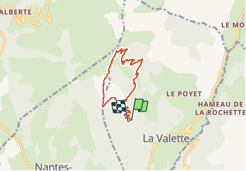
![](/images/other/stat-length.png)
![Excursión Senderismo La Valette - Boucle au pied du Piquet de Nantes - Photo](https://media.geolcdn.com/t/1900/400/deb2fa0b-e4a7-4275-aac0-fd48c06a7f57.jpg&format=pjpeg&maxdim=2)
Boucle au pied du Piquet de Nantes
GuyVachet
Usuario
![Longitud](/images/other/stat-length.png)
![Altitud máxima](https://static1.geolcdn.com/siteimages/upload/files/1508320355ic_sort_altitude_max_24dp.png)
![Desnivel positivo](https://static1.geolcdn.com/siteimages/upload/files/1508320355ic_sort_den_pos_24dp.png)
![Km-Effort](/images/other/stat-length.png)
![Altitud mínima](https://static1.geolcdn.com/siteimages/upload/files/1508320355ic_sort_altitude_min_24dp.png)
![Desnivel negativo](https://static1.geolcdn.com/siteimages/upload/files/1508320355ic_sort_den_neg_24dp.png)
![Boucle](https://static1.geolcdn.com/siteimages/upload/files/16400158638029165_repeat_loop_refresh_sync_direction_icon.png)
![Senderismo](https://static1.geolcdn.com/sitytour/trail-icons/101.png)
5h36
Dificultad : Difícil
![Escanee este código QR para abrir la excursión en la aplicación SityTrail](https://capi.geolives.com/qq0zvz2zws4bq2lad0pu/sitytour/trails/2435253/qr.png?size=200)
Aplicación GPS de excursión GRATIS
A propósito
Ruta Senderismo de 8,2 km a descubrir en Auvergne-Rhône-Alpes, Isère, La Valette. Esta ruta ha sido propuesta por GuyVachet.
Descripción
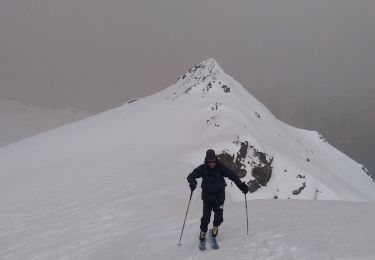
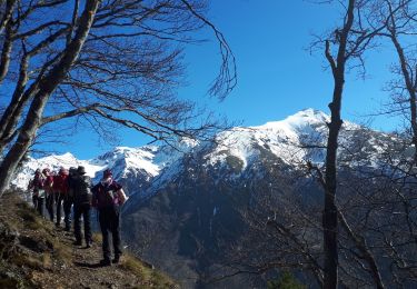
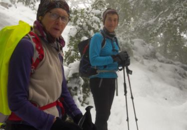
Boucle en approche du Piquet de Nantes par le Rocher Noir. Montée par la Grande Combe, itinéraire moins couru que celui utilisé pour la descente. Lorsqu'on prend pied sur la croupe (1550m) la montée dans l’alpage devient très soutenue. A la Fontaine de Bigasset, il ne restait que 230m à gravir pour atteindre le Piquet de Nantes mais du fait des conditions du jour, nous avons préféré en rester là et descendre par le chemin plus classique qui est particulièrement agréable.
Localización
Comentarios
Excursiones cerca
![Excursión Senderismo Lavaldens - Le Mollard - Lac Rif Bruyant 01/10/2023 - Photo](https://media.geolcdn.com/t/375/260/19c40cca-c1c5-4cd2-837c-cfeae0558b05.jpg&format=jpg&maxdim=2)
![Senderismo Senderismo](https://static1.geolcdn.com/sitytour/trail-icons/101.png)
Senderismo
![](/images/other/stat-length.png)
![](https://static1.geolcdn.com/siteimages/upload/files/16400158638029165_repeat_loop_refresh_sync_direction_icon.png)
![Excursión Senderismo Lavaldens - 2022-07-20_17h08m14_Rif Bruyant - Photo](https://media.geolcdn.com/t/375/260/ext.jpg?maxdim=2&url=https%3A%2F%2Fstatic1.geolcdn.com%2Fsiteimages%2Fupload%2Ffiles%2F1553511878bg_sport_marche.png)
![Senderismo Senderismo](https://static1.geolcdn.com/sitytour/trail-icons/101.png)
Senderismo
![](/images/other/stat-length.png)
![](https://static1.geolcdn.com/siteimages/upload/files/16400158638029165_repeat_loop_refresh_sync_direction_icon.png)
![Excursión Esquí de fondo Saint-Honoré - Le perollier, le Grand Serre - Photo](https://media.geolcdn.com/t/375/260/8f028379-4012-403e-a754-1ba5ea0046bf.jpg&format=jpg&maxdim=2)
![Esquí de fondo Esquí de fondo](https://static1.geolcdn.com/sitytour/trail-icons/503.png)
Esquí de fondo
![](/images/other/stat-length.png)
![](https://static1.geolcdn.com/siteimages/upload/files/16400158638029165_repeat_loop_refresh_sync_direction_icon.png)
![Excursión Esquí de fondo Saint-Honoré - Tabor de la Mûre - Photo](https://media.geolcdn.com/t/375/260/20d14802-7ff5-4d88-956a-7b9a995b765e.jpg&format=jpg&maxdim=2)
![Esquí de fondo Esquí de fondo](https://static1.geolcdn.com/sitytour/trail-icons/503.png)
Esquí de fondo
![](/images/other/stat-length.png)
![](https://static1.geolcdn.com/siteimages/upload/files/16400158638029165_repeat_loop_refresh_sync_direction_icon.png)
![Excursión Senderismo Lavaldens - Rif Bruyant - Photo](https://media.geolcdn.com/t/375/260/8dcecefd-d7fb-4568-9f12-c9e9cddea53d.jpg&format=jpg&maxdim=2)
![Senderismo Senderismo](https://static1.geolcdn.com/sitytour/trail-icons/101.png)
Senderismo
![](/images/other/stat-length.png)
![](https://static1.geolcdn.com/siteimages/upload/files/16400158638029165_repeat_loop_refresh_sync_direction_icon.png)
![Excursión Senderismo Lavaldens - Lavaldens 400 + - Photo](https://media.geolcdn.com/t/375/260/45b87e76-5e2f-44a8-8782-86a98ed8c427.jpg&format=jpg&maxdim=2)
![Senderismo Senderismo](https://static1.geolcdn.com/sitytour/trail-icons/101.png)
Senderismo
![](/images/other/stat-length.png)
![](https://static1.geolcdn.com/siteimages/upload/files/16400158638029165_repeat_loop_refresh_sync_direction_icon.png)
![Excursión Senderismo Saint-Honoré - Le Grand Serre - Photo](https://media.geolcdn.com/t/375/260/ea564edc-db3e-467a-9f34-8236705096bb.jpg&format=jpg&maxdim=2)
![Senderismo Senderismo](https://static1.geolcdn.com/sitytour/trail-icons/101.png)
Senderismo
![](/images/other/stat-length.png)
![](https://static1.geolcdn.com/siteimages/upload/files/16400158638029165_repeat_loop_refresh_sync_direction_icon.png)
![Excursión Senderismo La Valette - La cabane de Poyet en circuit - Photo](https://media.geolcdn.com/t/375/260/5619e671-6185-4bcc-8e40-810ed807016c.jpg&format=jpg&maxdim=2)
![Senderismo Senderismo](https://static1.geolcdn.com/sitytour/trail-icons/101.png)
Senderismo
![](/images/other/stat-length.png)
![](https://static1.geolcdn.com/siteimages/upload/files/16400158638029165_repeat_loop_refresh_sync_direction_icon.png)
![Excursión Senderismo La Valette - Cabane ONF du Poyet, depuis la Valette - Photo](https://media.geolcdn.com/t/375/260/93222bd8-8947-41da-825b-3739799a19df.jpg&format=jpg&maxdim=2)
![Senderismo Senderismo](https://static1.geolcdn.com/sitytour/trail-icons/101.png)
Senderismo
![](/images/other/stat-length.png)
![](https://static1.geolcdn.com/siteimages/upload/files/16400158638029165_repeat_loop_refresh_sync_direction_icon.png)