![](/images/other/stat-length.png)
![Excursión Bici de montaña Genappe - 2020-06-12_09h31m19_activity_3122256699 - Photo](https://media.geolcdn.com/t/1900/400/ext.pjpeg?maxdim=2&url=https%3A%2F%2Fstatic1.geolcdn.com%2Fsiteimages%2Fupload%2Ffiles%2F1524743154velo.jpg)
2020-06-12_09h31m19_activity_3122256699
DidierDHane
Usuario
![Longitud](/images/other/stat-length.png)
Longitud
32 km
![Altitud máxima](https://static1.geolcdn.com/siteimages/upload/files/1508320355ic_sort_altitude_max_24dp.png)
Altitud máxima
162 m
![Desnivel positivo](https://static1.geolcdn.com/siteimages/upload/files/1508320355ic_sort_den_pos_24dp.png)
Desnivel positivo
471 m
![Km-Effort](/images/other/stat-length.png)
Km-Effort
38 km
![Altitud mínima](https://static1.geolcdn.com/siteimages/upload/files/1508320355ic_sort_altitude_min_24dp.png)
Altitud mínima
87 m
![Desnivel negativo](https://static1.geolcdn.com/siteimages/upload/files/1508320355ic_sort_den_neg_24dp.png)
Desnivel negativo
464 m
![Boucle](https://static1.geolcdn.com/siteimages/upload/files/16400158638029165_repeat_loop_refresh_sync_direction_icon.png)
Boucle
Sí
Fecha de creación :
2020-06-12 07:31:22.452
Última modificación :
2020-06-13 07:00:39.382
![Bici de montaña](https://static1.geolcdn.com/sitytour/trail-icons/202.png)
2h33
Dificultad : Difícil
![Escanee este código QR para abrir la excursión en la aplicación SityTrail](https://capi.geolives.com/qq0zvz2zws4bq2lad0pu/sitytour/trails/2433073/qr.png?size=200)
Aplicación GPS de excursión GRATIS
A propósito
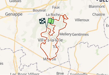
Ruta Bici de montaña de 32 km a descubrir en Valonia, Brabante Valón, Genappe. Esta ruta ha sido propuesta por DidierDHane.
Descripción
Très belle boucle VTT de 32 km au départ de la chouette brasserie le chalet de la forêt à Villers la ville
Localización
País:
Belgium
Región :
Valonia
Departamento/provincia :
Brabante Valón
Municipio :
Genappe
Localidad:
Baisy-Thy
Salida:(Dec)
Salida:(UTM)
608049 ; 5605419 (31U) N.
Comentarios
Excursiones cerca
![Excursión Senderismo Villers-la-Ville - RB-Bw-10-raccourci 2 - À travers campagnes et forêts, autour des ruines d’une prestigieuse abbaye - Photo](https://media.geolcdn.com/t/375/260/ext.jpg?maxdim=2&url=https%3A%2F%2Fservices.sitytrail.com%2FGeolivesWS%2FDownloadMedia.ashx%3FTrailID%3D220359%26Media%3Db52f8a40-bd4e-4201-848f-58c9caafd869.jpg)
![Senderismo Senderismo](https://static1.geolcdn.com/sitytour/trail-icons/101.png)
RB-Bw-10-raccourci 2 - À travers campagnes et forêts, autour des ruines d’une...
Senderismo
Difícil
(25)
Villers-la-Ville,
Valonia,
Brabante Valón,
Belgium
![](/images/other/stat-length.png)
13,3 km | 16,4 km-effort
3h 44min
![](https://static1.geolcdn.com/siteimages/upload/files/16400158638029165_repeat_loop_refresh_sync_direction_icon.png)
Sí
![Excursión Senderismo Villers-la-Ville - RB-Bw-10-raccourci 1 - À travers campagnes et forêts, autour des ruines d’une prestigieuse abbaye - Photo](https://media.geolcdn.com/t/375/260/ext.jpg?maxdim=2&url=https%3A%2F%2Fservices.sitytrail.com%2FGeolivesWS%2FDownloadMedia.ashx%3FTrailID%3D220358%26Media%3Db52f8a40-bd4e-4201-848f-58c9caafd869.jpg)
![Senderismo Senderismo](https://static1.geolcdn.com/sitytour/trail-icons/101.png)
RB-Bw-10-raccourci 1 - À travers campagnes et forêts, autour des ruines d’une...
Senderismo
Muy difícil
(12)
Villers-la-Ville,
Valonia,
Brabante Valón,
Belgium
![](/images/other/stat-length.png)
24 km | 30 km-effort
6h 43min
![](https://static1.geolcdn.com/siteimages/upload/files/16400158638029165_repeat_loop_refresh_sync_direction_icon.png)
Sí
![Excursión Senderismo Genappe - RB-Bw-09 Raccourci 1 & 2 - Autour de la jeune Dyle et de ses affluents - Photo](https://media.geolcdn.com/t/375/260/ext.jpg?maxdim=2&url=https%3A%2F%2Fservices.sitytrail.com%2FGeolivesWS%2FDownloadMedia.ashx%3FTrailID%3D220340%26Media%3Dd40b4c5b-4793-41f9-ac7b-fe40a955ea25.jpg)
![Senderismo Senderismo](https://static1.geolcdn.com/sitytour/trail-icons/101.png)
RB-Bw-09 Raccourci 1 & 2 - Autour de la jeune Dyle et de ses affluents
Senderismo
Difícil
(11)
Genappe,
Valonia,
Brabante Valón,
Belgium
![](/images/other/stat-length.png)
9,7 km | 12,5 km-effort
2h 50min
![](https://static1.geolcdn.com/siteimages/upload/files/16400158638029165_repeat_loop_refresh_sync_direction_icon.png)
Sí
![Excursión Senderismo Genappe - RB-Bw-09 Raccourci 1 - Autour de la jeune Dyle et de ses affluents - Photo](https://media.geolcdn.com/t/375/260/ext.jpg?maxdim=2&url=https%3A%2F%2Fservices.sitytrail.com%2FGeolivesWS%2FDownloadMedia.ashx%3FTrailID%3D220337%26Media%3Dcacfbcff-3084-47a0-8267-9fc97c2da542.jpg)
![Senderismo Senderismo](https://static1.geolcdn.com/sitytour/trail-icons/101.png)
RB-Bw-09 Raccourci 1 - Autour de la jeune Dyle et de ses affluents
Senderismo
Difícil
(11)
Genappe,
Valonia,
Brabante Valón,
Belgium
![](/images/other/stat-length.png)
13,2 km | 16,9 km-effort
3h 49min
![](https://static1.geolcdn.com/siteimages/upload/files/16400158638029165_repeat_loop_refresh_sync_direction_icon.png)
Sí
![Excursión Senderismo Villers-la-Ville - RB-Bw-10 -À travers campagnes et forêts, autour des ruines d’une prestigieuse abbaye - Photo](https://media.geolcdn.com/t/375/260/ext.jpg?maxdim=2&url=https%3A%2F%2Fservices.sitytrail.com%2FGeolivesWS%2FDownloadMedia.ashx%3FTrailID%3D179585%26Media%3Db52f8a40-bd4e-4201-848f-58c9caafd869.jpg)
![Senderismo Senderismo](https://static1.geolcdn.com/sitytour/trail-icons/101.png)
RB-Bw-10 -À travers campagnes et forêts, autour des ruines d’une prestigieuse...
Senderismo
Muy difícil
(6)
Villers-la-Ville,
Valonia,
Brabante Valón,
Belgium
![](/images/other/stat-length.png)
26 km | 32 km-effort
7h 15min
![](https://static1.geolcdn.com/siteimages/upload/files/16400158638029165_repeat_loop_refresh_sync_direction_icon.png)
Sí
![Excursión Senderismo Genappe - RB-Bw-09 - Autour de la jeune Dyle et de ses affluents - Photo](https://media.geolcdn.com/t/375/260/ext.jpg?maxdim=2&url=https%3A%2F%2Fservices.sitytrail.com%2FGeolivesWS%2FDownloadMedia.ashx%3FTrailID%3D179584%26Media%3Dd40b4c5b-4793-41f9-ac7b-fe40a955ea25.jpg)
![Senderismo Senderismo](https://static1.geolcdn.com/sitytour/trail-icons/101.png)
RB-Bw-09 - Autour de la jeune Dyle et de ses affluents
Senderismo
Medio
(9)
Genappe,
Valonia,
Brabante Valón,
Belgium
![](/images/other/stat-length.png)
22 km | 28 km-effort
5h 59min
![](https://static1.geolcdn.com/siteimages/upload/files/16400158638029165_repeat_loop_refresh_sync_direction_icon.png)
Sí
![Excursión Senderismo Genappe - Genappe - Circuit Natura 2000, des sites qui valent le détour ! - Bw03 - Photo](https://media.geolcdn.com/t/375/260/ext.jpg?maxdim=2&url=https%3A%2F%2Fservices.sitytrail.com%2FGeolivesWS%2FDownloadMedia.ashx%3FTrailID%3D356410%26Media%3D9ffde3d0-226c-45a8-b2a5-1fc6dfbe0f90.jpg)
![Senderismo Senderismo](https://static1.geolcdn.com/sitytour/trail-icons/101.png)
Genappe - Circuit Natura 2000, des sites qui valent le détour ! - Bw03
Senderismo
Medio
(6)
Genappe,
Valonia,
Brabante Valón,
Belgium
![](/images/other/stat-length.png)
7,9 km | 9,7 km-effort
2h 6min
![](https://static1.geolcdn.com/siteimages/upload/files/16400158638029165_repeat_loop_refresh_sync_direction_icon.png)
Sí
![Excursión Senderismo Court-Saint-Étienne - GG2-Bw-22_La-Roche-Blanmont_2021-11-04 - Photo](https://media.geolcdn.com/t/375/260/ext.jpg?maxdim=2&url=https%3A%2F%2Fmedia.geolcdn.com%2Ff%2F2a6f461f-efef-416e-b536-c468aeb7dc39.jpg)
![Senderismo Senderismo](https://static1.geolcdn.com/sitytour/trail-icons/101.png)
GG2-Bw-22_La-Roche-Blanmont_2021-11-04
Senderismo
Medio
(2)
Court-Saint-Étienne,
Valonia,
Brabante Valón,
Belgium
![](/images/other/stat-length.png)
21 km | 26 km-effort
5h 51min
![](https://static1.geolcdn.com/siteimages/upload/files/16400158638029165_repeat_loop_refresh_sync_direction_icon.png)
No
![Excursión Senderismo Villers-la-Ville - Balade forestière à Villers la Ville - Photo](https://media.geolcdn.com/t/375/260/ext.jpg?maxdim=2&url=https%3A%2F%2Fservices.sitytrail.com%2FGeolivesWS%2FDownloadMedia.ashx%3FTrailID%3D120927%26Media%3D124af64a-52e1-4866-a6e4-05b50b4835ef.JPG)
![Senderismo Senderismo](https://static1.geolcdn.com/sitytour/trail-icons/101.png)
Balade forestière à Villers la Ville
Senderismo
Fácil
(5)
Villers-la-Ville,
Valonia,
Brabante Valón,
Belgium
![](/images/other/stat-length.png)
11,5 km | 14,1 km-effort
3h 0min
![](https://static1.geolcdn.com/siteimages/upload/files/16400158638029165_repeat_loop_refresh_sync_direction_icon.png)
Sí