![](/images/other/stat-length.png)
![Excursión Senderismo Grendelbruch - Rando autour de Grendelbruch - Photo](https://media.geolcdn.com/t/1900/400/ext.pjpeg?maxdim=2&url=https%3A%2F%2Fstatic1.geolcdn.com%2Fsiteimages%2Fupload%2Ffiles%2F1553511878bg_sport_marche.png)
Rando autour de Grendelbruch
vaillantjm
Usuario
![Longitud](/images/other/stat-length.png)
Longitud
16,7 km
![Altitud máxima](https://static1.geolcdn.com/siteimages/upload/files/1508320355ic_sort_altitude_max_24dp.png)
Altitud máxima
838 m
![Desnivel positivo](https://static1.geolcdn.com/siteimages/upload/files/1508320355ic_sort_den_pos_24dp.png)
Desnivel positivo
638 m
![Km-Effort](/images/other/stat-length.png)
Km-Effort
25 km
![Altitud mínima](https://static1.geolcdn.com/siteimages/upload/files/1508320355ic_sort_altitude_min_24dp.png)
Altitud mínima
472 m
![Desnivel negativo](https://static1.geolcdn.com/siteimages/upload/files/1508320355ic_sort_den_neg_24dp.png)
Desnivel negativo
635 m
![Boucle](https://static1.geolcdn.com/siteimages/upload/files/16400158638029165_repeat_loop_refresh_sync_direction_icon.png)
Boucle
Sí
Fecha de creación :
2020-06-07 17:01:48.834
Última modificación :
2024-05-02 16:36:35.795
![Senderismo](https://static1.geolcdn.com/sitytour/trail-icons/101.png)
5h40
Dificultad : Difícil
![Escanee este código QR para abrir la excursión en la aplicación SityTrail](https://capi.geolives.com/qq0zvz2zws4bq2lad0pu/sitytour/trails/2428159/qr.png?size=200)
Aplicación GPS de excursión GRATIS
A propósito
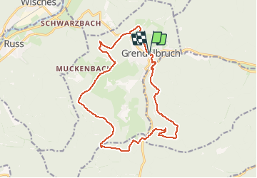
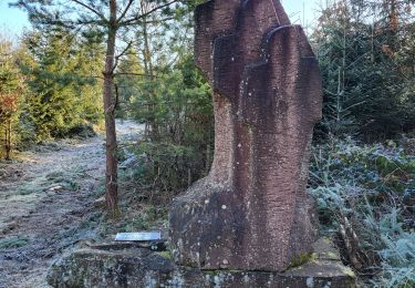
Ruta Senderismo de 16,7 km a descubrir en Gran Este, Bajo-Rin, Grendelbruch. Esta ruta ha sido propuesta por vaillantjm.
Descripción
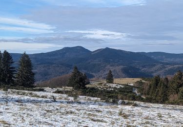
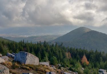
Belle variété de sentiers, principalement en forêt. Le Signal de Grendelbuch est est un vaste espace ouvert et grandiose. Quelques points de vue magnifiques. Pas de réelles difficultés sur le parcours. Merci à daft27!
Localización
País:
France
Región :
Gran Este
Departamento/provincia :
Bajo-Rin
Municipio :
Grendelbruch
Localidad:
Unknown
Salida:(Dec)
Salida:(UTM)
376124 ; 5372390 (32U) N.
Comentarios
Excursiones cerca
![Excursión Senderismo Urmatt - Cascade Soultzbach - Urmatt - Photo](https://media.geolcdn.com/t/375/260/20e7652d-0a73-4a1a-a692-b5e1164e2be3.jpg&format=jpg&maxdim=2)
![Senderismo Senderismo](https://static1.geolcdn.com/sitytour/trail-icons/101.png)
Cascade Soultzbach - Urmatt
Senderismo
Muy difícil
(1)
Urmatt,
Gran Este,
Bajo-Rin,
France
![](/images/other/stat-length.png)
14,9 km | 21 km-effort
4h 46min
![](https://static1.geolcdn.com/siteimages/upload/files/16400158638029165_repeat_loop_refresh_sync_direction_icon.png)
Sí
![Excursión Senderismo Ottrott - Montée vers le Mont Sainte-Odile - Photo](https://media.geolcdn.com/t/375/260/ext.jpg?maxdim=2&url=https%3A%2F%2Fservices.sitytrail.com%2FGeolivesWS%2FDownloadMedia.ashx%3FTrailID%3D453779%26Media%3Dfix__20150802160011.jpg)
![Senderismo Senderismo](https://static1.geolcdn.com/sitytour/trail-icons/101.png)
Montée vers le Mont Sainte-Odile
Senderismo
Difícil
(1)
Ottrott,
Gran Este,
Bajo-Rin,
France
![](/images/other/stat-length.png)
17,6 km | 26 km-effort
5h 52min
![](https://static1.geolcdn.com/siteimages/upload/files/16400158638029165_repeat_loop_refresh_sync_direction_icon.png)
Sí
![Excursión Paseo ecuestre Mollkirch - suuntoapp-HorsebackRiding-2024-04-28T06-24-49Z - Photo](https://media.geolcdn.com/t/375/260/492e641b-5f59-4751-a81d-a41633bc94a3.jpg&format=jpg&maxdim=2)
![Paseo ecuestre Paseo ecuestre](https://static1.geolcdn.com/sitytour/trail-icons/301.png)
suuntoapp-HorsebackRiding-2024-04-28T06-24-49Z
Paseo ecuestre
Difícil
Mollkirch,
Gran Este,
Bajo-Rin,
France
![](/images/other/stat-length.png)
34 km | 48 km-effort
6h 20min
![](https://static1.geolcdn.com/siteimages/upload/files/16400158638029165_repeat_loop_refresh_sync_direction_icon.png)
Sí
![Excursión Senderismo Lutzelhouse - suuntoapp-Hiking-2024-01-28T11-41-12Z - Photo](https://media.geolcdn.com/t/375/260/a449e661-4c19-4b4c-bdec-0ce5cf123351.jpg&format=jpg&maxdim=2)
![Senderismo Senderismo](https://static1.geolcdn.com/sitytour/trail-icons/101.png)
suuntoapp-Hiking-2024-01-28T11-41-12Z
Senderismo
Medio
Lutzelhouse,
Gran Este,
Bajo-Rin,
France
![](/images/other/stat-length.png)
15,3 km | 25 km-effort
5h 45min
![](https://static1.geolcdn.com/siteimages/upload/files/16400158638029165_repeat_loop_refresh_sync_direction_icon.png)
Sí
![Excursión Senderismo Grendelbruch - suuntoapp-Hiking-2024-01-21T12-04-41Z - Photo](https://media.geolcdn.com/t/375/260/4df6b66c-98a9-4be9-8660-05898a66c498.jpg&format=jpg&maxdim=2)
![Senderismo Senderismo](https://static1.geolcdn.com/sitytour/trail-icons/101.png)
suuntoapp-Hiking-2024-01-21T12-04-41Z
Senderismo
Fácil
Grendelbruch,
Gran Este,
Bajo-Rin,
France
![](/images/other/stat-length.png)
12,1 km | 19,3 km-effort
4h 23min
![](https://static1.geolcdn.com/siteimages/upload/files/16400158638029165_repeat_loop_refresh_sync_direction_icon.png)
Sí
![Excursión Paseo ecuestre Mollkirch - 2023-05-28 Picnic CVA Cabane des 5 routes - Photo](https://media.geolcdn.com/t/375/260/d96b3efa-5f19-487f-8d02-9856287ebbe7.jpg&format=jpg&maxdim=2)
![Paseo ecuestre Paseo ecuestre](https://static1.geolcdn.com/sitytour/trail-icons/301.png)
2023-05-28 Picnic CVA Cabane des 5 routes
Paseo ecuestre
Medio
Mollkirch,
Gran Este,
Bajo-Rin,
France
![](/images/other/stat-length.png)
36 km | 51 km-effort
6h 39min
![](https://static1.geolcdn.com/siteimages/upload/files/16400158638029165_repeat_loop_refresh_sync_direction_icon.png)
Sí
![Excursión Senderismo Lutzelhouse - 2019-11-30 Marche Rocher de Mutzig Noll - Photo](https://media.geolcdn.com/t/375/260/f1ae836b-d063-4b16-aefc-2c8e07433ca1.jpg&format=jpg&maxdim=2)
![Senderismo Senderismo](https://static1.geolcdn.com/sitytour/trail-icons/101.png)
2019-11-30 Marche Rocher de Mutzig Noll
Senderismo
Muy fácil
Lutzelhouse,
Gran Este,
Bajo-Rin,
France
![](/images/other/stat-length.png)
18,7 km | 29 km-effort
4h 39min
![](https://static1.geolcdn.com/siteimages/upload/files/16400158638029165_repeat_loop_refresh_sync_direction_icon.png)
Sí
![Excursión Caballo Rosheim - 2013-05-12 Picnic CVA Maennelstein - Photo](https://media.geolcdn.com/t/375/260/ext.jpg?maxdim=2&url=https%3A%2F%2Fstatic1.geolcdn.com%2Fsiteimages%2Fupload%2Ffiles%2F1524743154cheval.jpg)
![Caballo Caballo](https://static1.geolcdn.com/sitytour/trail-icons/300.png)
2013-05-12 Picnic CVA Maennelstein
Caballo
Medio
(1)
Rosheim,
Gran Este,
Bajo-Rin,
France
![](/images/other/stat-length.png)
29 km | 41 km-effort
2h 33min
![](https://static1.geolcdn.com/siteimages/upload/files/16400158638029165_repeat_loop_refresh_sync_direction_icon.png)
Sí
![Excursión Senderismo Lutzelhouse - Lutzelhouse - place des musiciens - sculptures - grotte du loup - cascade de Soulzbach - Porte de pierre - Photo](https://media.geolcdn.com/t/375/260/3c8a3f56-9ea0-46c2-a96b-81a1c8bec17b.jpg&format=jpg&maxdim=2)
![Senderismo Senderismo](https://static1.geolcdn.com/sitytour/trail-icons/101.png)
Lutzelhouse - place des musiciens - sculptures - grotte du loup - cascade de ...
Senderismo
Muy difícil
Lutzelhouse,
Gran Este,
Bajo-Rin,
France
![](/images/other/stat-length.png)
24 km | 37 km-effort
8h 29min
![](https://static1.geolcdn.com/siteimages/upload/files/16400158638029165_repeat_loop_refresh_sync_direction_icon.png)
Sí