![](/images/other/stat-length.png)
![Excursión Senderismo Volvent - col de la vache - praloubeau - sous la brèche et retour - Photo](https://media.geolcdn.com/t/1900/400/ec2bfbb5-c45f-4e6d-af7f-d9dcdf368739.jpg&format=pjpeg&maxdim=2)
col de la vache - praloubeau - sous la brèche et retour
MARC_26
Usuario
![Longitud](/images/other/stat-length.png)
Longitud
15,6 km
![Altitud máxima](https://static1.geolcdn.com/siteimages/upload/files/1508320355ic_sort_altitude_max_24dp.png)
Altitud máxima
1514 m
![Desnivel positivo](https://static1.geolcdn.com/siteimages/upload/files/1508320355ic_sort_den_pos_24dp.png)
Desnivel positivo
770 m
![Km-Effort](/images/other/stat-length.png)
Km-Effort
26 km
![Altitud mínima](https://static1.geolcdn.com/siteimages/upload/files/1508320355ic_sort_altitude_min_24dp.png)
Altitud mínima
845 m
![Desnivel negativo](https://static1.geolcdn.com/siteimages/upload/files/1508320355ic_sort_den_neg_24dp.png)
Desnivel negativo
771 m
![Boucle](https://static1.geolcdn.com/siteimages/upload/files/16400158638029165_repeat_loop_refresh_sync_direction_icon.png)
Boucle
Sí
Fecha de creación :
2020-05-31 08:31:34.88
Última modificación :
2020-06-01 09:47:43.838
![Senderismo](https://static1.geolcdn.com/sitytour/trail-icons/101.png)
5h31
Dificultad : Difícil
![Escanee este código QR para abrir la excursión en la aplicación SityTrail](https://capi.geolives.com/qq0zvz2zws4bq2lad0pu/sitytour/trails/2419929/qr.png?size=200)
Aplicación GPS de excursión GRATIS
A propósito
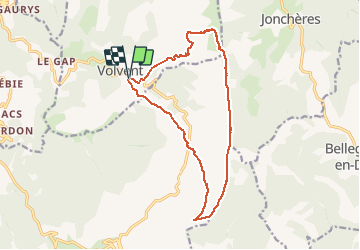
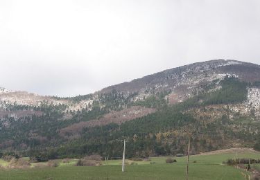
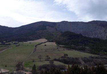
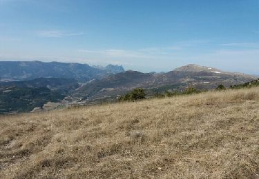
Ruta Senderismo de 15,6 km a descubrir en Auvergne-Rhône-Alpes, Drôme, Volvent. Esta ruta ha sido propuesta por MARC_26.
Descripción
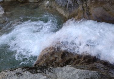
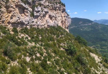
Belle balade avec de longues crêtes quand on est en haut.
Pour le retour mon téléphone s'est arrêté. suivre le chemin large (pas le premier) qui passe par le serre de guemard
Localización
País:
France
Región :
Auvergne-Rhône-Alpes
Departamento/provincia :
Drôme
Municipio :
Volvent
Localidad:
Unknown
Salida:(Dec)
Salida:(UTM)
686548 ; 4936378 (31T) N.
Comentarios
Excursiones cerca
![Excursión Senderismo Saint-Nazaire-le-Désert - 26 st Nazaire le desert - Photo](https://media.geolcdn.com/t/375/260/800f793b-c8e6-438c-bf52-c0a833bbf3e1.jpg&format=jpg&maxdim=2)
![Senderismo Senderismo](https://static1.geolcdn.com/sitytour/trail-icons/101.png)
26 st Nazaire le desert
Senderismo
Muy difícil
Saint-Nazaire-le-Désert,
Auvergne-Rhône-Alpes,
Drôme,
France
![](/images/other/stat-length.png)
8,5 km | 16 km-effort
5h 17min
![](https://static1.geolcdn.com/siteimages/upload/files/16400158638029165_repeat_loop_refresh_sync_direction_icon.png)
No
![Excursión Senderismo Volvent - 26 chalencon eyriau zel - Photo](https://media.geolcdn.com/t/375/260/153502c6-6d0b-49a9-b8eb-15eb863bb322.jpg&format=jpg&maxdim=2)
![Senderismo Senderismo](https://static1.geolcdn.com/sitytour/trail-icons/101.png)
26 chalencon eyriau zel
Senderismo
Medio
Volvent,
Auvergne-Rhône-Alpes,
Drôme,
France
![](/images/other/stat-length.png)
12,9 km | 23 km-effort
6h 13min
![](https://static1.geolcdn.com/siteimages/upload/files/16400158638029165_repeat_loop_refresh_sync_direction_icon.png)
No
![Excursión sport Jonchères - Jonchères Pivoines 2024 - Photo](https://media.geolcdn.com/t/375/260/8e0f4411-93b1-42ac-a4c2-86b49062ded0.jpg&format=jpg&maxdim=2)
Jonchères Pivoines 2024
sport
Muy fácil
Jonchères,
Auvergne-Rhône-Alpes,
Drôme,
France
![](/images/other/stat-length.png)
11,9 km | 20 km-effort
Desconocido
![](https://static1.geolcdn.com/siteimages/upload/files/16400158638029165_repeat_loop_refresh_sync_direction_icon.png)
Sí
![Excursión Raquetas de nieve Volvent - Servelle de Brette - Photo](https://media.geolcdn.com/t/375/260/049a8df2-2b16-40b5-a9d0-094d00ba47da.jpg&format=jpg&maxdim=2)
![Raquetas de nieve Raquetas de nieve](https://static1.geolcdn.com/sitytour/trail-icons/504.png)
Servelle de Brette
Raquetas de nieve
Medio
Volvent,
Auvergne-Rhône-Alpes,
Drôme,
France
![](/images/other/stat-length.png)
14,8 km | 25 km-effort
4h 4min
![](https://static1.geolcdn.com/siteimages/upload/files/16400158638029165_repeat_loop_refresh_sync_direction_icon.png)
Sí
![Excursión Senderismo Jonchères - Jonchères - Photo](https://media.geolcdn.com/t/375/260/157e7856-5eaf-40e9-be95-2ba6b62b45b6.jpg&format=jpg&maxdim=2)
![Senderismo Senderismo](https://static1.geolcdn.com/sitytour/trail-icons/101.png)
Jonchères
Senderismo
Muy fácil
Jonchères,
Auvergne-Rhône-Alpes,
Drôme,
France
![](/images/other/stat-length.png)
12,1 km | 21 km-effort
3h 58min
![](https://static1.geolcdn.com/siteimages/upload/files/16400158638029165_repeat_loop_refresh_sync_direction_icon.png)
Sí
![Excursión Senderismo Chalancon - Chalancon (26)Montagne Eyriau - Photo](https://media.geolcdn.com/t/375/260/e1e7d64c-ae8c-44c1-bef1-46573e2ead16.jpg&format=jpg&maxdim=2)
![Senderismo Senderismo](https://static1.geolcdn.com/sitytour/trail-icons/101.png)
Chalancon (26)Montagne Eyriau
Senderismo
Medio
Chalancon,
Auvergne-Rhône-Alpes,
Drôme,
France
![](/images/other/stat-length.png)
13,4 km | 24 km-effort
6h 16min
![](https://static1.geolcdn.com/siteimages/upload/files/16400158638029165_repeat_loop_refresh_sync_direction_icon.png)
No
![Excursión Senderismo Jonchères - 2016-04-09 Jonchères - Montagne de Praloubeau - Photo](https://media.geolcdn.com/t/375/260/a518ec77-466d-41c1-88e2-175223c4e0e5.jpg&format=jpg&maxdim=2)
![Senderismo Senderismo](https://static1.geolcdn.com/sitytour/trail-icons/101.png)
2016-04-09 Jonchères - Montagne de Praloubeau
Senderismo
Difícil
Jonchères,
Auvergne-Rhône-Alpes,
Drôme,
France
![](/images/other/stat-length.png)
11,4 km | 20 km-effort
4h 3min
![](https://static1.geolcdn.com/siteimages/upload/files/16400158638029165_repeat_loop_refresh_sync_direction_icon.png)
Sí
![Excursión Senderismo Jonchères - Les crêtes de Jonchères - Photo](https://media.geolcdn.com/t/375/260/ext.jpg?maxdim=2&url=https%3A%2F%2Fservices.sitytrail.com%2FGeolivesWS%2FDownloadMedia.ashx%3FTrailID%3D938621%26Media%3Dfe2b9ce4-f237-4dfc-8e96-7944381d8614.jpg)
![Senderismo Senderismo](https://static1.geolcdn.com/sitytour/trail-icons/101.png)
Les crêtes de Jonchères
Senderismo
Muy difícil
Jonchères,
Auvergne-Rhône-Alpes,
Drôme,
France
![](/images/other/stat-length.png)
13,5 km | 23 km-effort
4h 33min
![](https://static1.geolcdn.com/siteimages/upload/files/16400158638029165_repeat_loop_refresh_sync_direction_icon.png)
Sí
![Excursión Senderismo Volvent - crête de praloubeau - Photo](https://media.geolcdn.com/t/375/260/ext.jpg?maxdim=2&url=https%3A%2F%2Fservices.sitytrail.com%2FGeolivesWS%2FDownloadMedia.ashx%3FTrailID%3D712861%26Media%3Dfix__20170312133518.jpg)
![Senderismo Senderismo](https://static1.geolcdn.com/sitytour/trail-icons/101.png)
crête de praloubeau
Senderismo
Medio
Volvent,
Auvergne-Rhône-Alpes,
Drôme,
France
![](/images/other/stat-length.png)
15,4 km | 26 km-effort
5h 19min
![](https://static1.geolcdn.com/siteimages/upload/files/16400158638029165_repeat_loop_refresh_sync_direction_icon.png)
Sí