![](/images/other/stat-length.png)
![Excursión Bici eléctrica Wanze - tihange champia - Photo](https://media.geolcdn.com/t/1900/400/ext.pjpeg?maxdim=2&url=https%3A%2F%2Fstatic1.geolcdn.com%2Fsiteimages%2Fupload%2Ffiles%2F1524743154velo.jpg)
tihange champia
Lucdelmoitie
Usuario
![Longitud](/images/other/stat-length.png)
Longitud
21 km
![Altitud máxima](https://static1.geolcdn.com/siteimages/upload/files/1508320355ic_sort_altitude_max_24dp.png)
Altitud máxima
212 m
![Desnivel positivo](https://static1.geolcdn.com/siteimages/upload/files/1508320355ic_sort_den_pos_24dp.png)
Desnivel positivo
254 m
![Km-Effort](/images/other/stat-length.png)
Km-Effort
25 km
![Altitud mínima](https://static1.geolcdn.com/siteimages/upload/files/1508320355ic_sort_altitude_min_24dp.png)
Altitud mínima
50 m
![Desnivel negativo](https://static1.geolcdn.com/siteimages/upload/files/1508320355ic_sort_den_neg_24dp.png)
Desnivel negativo
255 m
![Boucle](https://static1.geolcdn.com/siteimages/upload/files/16400158638029165_repeat_loop_refresh_sync_direction_icon.png)
Boucle
Sí
Fecha de creación :
2020-05-28 12:26:29.724
Última modificación :
2020-06-02 18:42:19.442
![Bici eléctrica](https://static1.geolcdn.com/sitytour/trail-icons/205.png)
1h52
Dificultad : Fácil
![Escanee este código QR para abrir la excursión en la aplicación SityTrail](https://capi.geolives.com/qq0zvz2zws4bq2lad0pu/sitytour/trails/2414479/qr.png?size=200)
Aplicación GPS de excursión GRATIS
A propósito
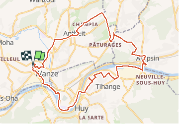
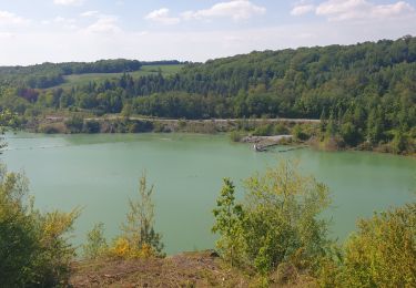
Ruta Bici eléctrica de 21 km a descubrir en Valonia, Lieja, Wanze. Esta ruta ha sido propuesta por Lucdelmoitie.
Descripción
Malgré quelques tronçons de chemins empierrés, praticable avec vélo électrique de ville ( sauf temps boueux évidemment )
Localización
País:
Belgium
Región :
Valonia
Departamento/provincia :
Lieja
Municipio :
Wanze
Localidad:
Wanze
Salida:(Dec)
Salida:(UTM)
656438 ; 5600592 (31U) N.
Comentarios
Excursiones cerca
![Excursión Senderismo Huy - Huy Ben-Ahin. Natura 2000 des sites qui valent le détour ! Lg9 - Photo](https://media.geolcdn.com/t/375/260/ext.jpg?maxdim=2&url=https%3A%2F%2Fservices.sitytrail.com%2FGeolivesWS%2FDownloadMedia.ashx%3FTrailID%3D182987%26Media%3Da8459ff4-9180-431b-88aa-1e326f78de1f.JPG)
![Senderismo Senderismo](https://static1.geolcdn.com/sitytour/trail-icons/101.png)
Huy Ben-Ahin. Natura 2000 des sites qui valent le détour ! Lg9
Senderismo
Medio
(15)
Huy,
Valonia,
Lieja,
Belgium
![](/images/other/stat-length.png)
7,9 km | 10,7 km-effort
2h 18min
![](https://static1.geolcdn.com/siteimages/upload/files/16400158638029165_repeat_loop_refresh_sync_direction_icon.png)
No
![Excursión Senderismo Wanze - Huccorgne Hesbaye Promenade-des-Chevreuils Haspengouw - 9 km RT - Photo](https://media.geolcdn.com/t/375/260/ext.jpg?maxdim=2&url=https%3A%2F%2Fstatic1.geolcdn.com%2Fsiteimages%2Fupload%2Ffiles%2F1553511878bg_sport_marche.png)
![Senderismo Senderismo](https://static1.geolcdn.com/sitytour/trail-icons/101.png)
Huccorgne Hesbaye Promenade-des-Chevreuils Haspengouw - 9 km RT
Senderismo
Muy fácil
(5)
Wanze,
Valonia,
Lieja,
Belgium
![](/images/other/stat-length.png)
9,3 km | 11,9 km-effort
Desconocido
![](https://static1.geolcdn.com/siteimages/upload/files/16400158638029165_repeat_loop_refresh_sync_direction_icon.png)
Sí
![Senderismo Senderismo](https://static1.geolcdn.com/sitytour/trail-icons/101.png)
CHHATEAU DE MOHA
Senderismo
Medio
(2)
Wanze,
Valonia,
Lieja,
Belgium
![](/images/other/stat-length.png)
7,3 km | 9,1 km-effort
1h 58min
![](https://static1.geolcdn.com/siteimages/upload/files/16400158638029165_repeat_loop_refresh_sync_direction_icon.png)
Sí
![Excursión Senderismo Huy - TIHANGE (Temple Tibétain). - Photo](https://media.geolcdn.com/t/375/260/ext.jpg?maxdim=2&url=https%3A%2F%2Fservices.sitytrail.com%2FGeolivesWS%2FDownloadMedia.ashx%3FTrailID%3D458488%26Media%3Dfix__20150813122829.jpg)
![Senderismo Senderismo](https://static1.geolcdn.com/sitytour/trail-icons/101.png)
TIHANGE (Temple Tibétain).
Senderismo
Muy fácil
(2)
Huy,
Valonia,
Lieja,
Belgium
![](/images/other/stat-length.png)
11,5 km | 13,9 km-effort
3h 1min
![](https://static1.geolcdn.com/siteimages/upload/files/16400158638029165_repeat_loop_refresh_sync_direction_icon.png)
Sí
![Excursión Senderismo Wanze - antheit - Photo](https://media.geolcdn.com/t/375/260/63403872-a8da-4090-b10f-81e240d58ff7.jpg&format=jpg&maxdim=2)
![Senderismo Senderismo](https://static1.geolcdn.com/sitytour/trail-icons/101.png)
![Excursión Senderismo Wanze - les long pieds anthey - Photo](https://media.geolcdn.com/t/375/260/04ed0be7-9f2b-4519-ab41-baa0902f0e32.jpg&format=jpg&maxdim=2)
![Senderismo Senderismo](https://static1.geolcdn.com/sitytour/trail-icons/101.png)
les long pieds anthey
Senderismo
Medio
(1)
Wanze,
Valonia,
Lieja,
Belgium
![](/images/other/stat-length.png)
12,9 km | 16 km-effort
2h 34min
![](https://static1.geolcdn.com/siteimages/upload/files/16400158638029165_repeat_loop_refresh_sync_direction_icon.png)
Sí
![Excursión Senderismo Héron - champis-couthuin - Photo](https://media.geolcdn.com/t/375/260/ext.jpg?maxdim=2&url=https%3A%2F%2Fservices.sitytrail.com%2FGeolivesWS%2FDownloadMedia.ashx%3FTrailID%3D487688%26Media%3Dfix__20151031115446.jpg)
![Senderismo Senderismo](https://static1.geolcdn.com/sitytour/trail-icons/101.png)
champis-couthuin
Senderismo
Muy fácil
(2)
Héron,
Valonia,
Lieja,
Belgium
![](/images/other/stat-length.png)
4,4 km | 5,3 km-effort
2h 25min
![](https://static1.geolcdn.com/siteimages/upload/files/16400158638029165_repeat_loop_refresh_sync_direction_icon.png)
Sí
![Excursión Senderismo Huy - Ben Ahin La Solière - Photo](https://media.geolcdn.com/t/375/260/ext.jpg?maxdim=2&url=https%3A%2F%2Fservices.sitytrail.com%2FGeolivesWS%2FDownloadMedia.ashx%3FTrailID%3D42709%26Media%3Dl)
![Senderismo Senderismo](https://static1.geolcdn.com/sitytour/trail-icons/101.png)
Ben Ahin La Solière
Senderismo
Muy fácil
(1)
Huy,
Valonia,
Lieja,
Belgium
![](/images/other/stat-length.png)
14,3 km | 19 km-effort
4h 54min
![](https://static1.geolcdn.com/siteimages/upload/files/16400158638029165_repeat_loop_refresh_sync_direction_icon.png)
Sí
![Excursión Senderismo Wanze - Balade de Moha à Huccorgne - Photo](https://media.geolcdn.com/t/375/260/79c0e9b7-562a-4cd6-b98a-d6b2066aed18.jpg&format=jpg&maxdim=2)
![Senderismo Senderismo](https://static1.geolcdn.com/sitytour/trail-icons/101.png)
Balade de Moha à Huccorgne
Senderismo
Difícil
Wanze,
Valonia,
Lieja,
Belgium
![](/images/other/stat-length.png)
9,7 km | 12,2 km-effort
2h 45min
![](https://static1.geolcdn.com/siteimages/upload/files/16400158638029165_repeat_loop_refresh_sync_direction_icon.png)
Sí