![](/images/other/stat-length.png)
![Excursión Senderismo Brie-Comte-Robert - Chemin des Roses - Brie-Comte-Robert / Yébles - Photo](https://media.geolcdn.com/t/1900/400/ad9d12b0-844d-4c4d-b32d-96ebd2db4fb0.bmp&format=pjpeg&maxdim=2)
Chemin des Roses - Brie-Comte-Robert / Yébles
Bntg
Usuario
![Longitud](/images/other/stat-length.png)
![Altitud máxima](https://static1.geolcdn.com/siteimages/upload/files/1508320355ic_sort_altitude_max_24dp.png)
![Desnivel positivo](https://static1.geolcdn.com/siteimages/upload/files/1508320355ic_sort_den_pos_24dp.png)
![Km-Effort](/images/other/stat-length.png)
![Altitud mínima](https://static1.geolcdn.com/siteimages/upload/files/1508320355ic_sort_altitude_min_24dp.png)
![Desnivel negativo](https://static1.geolcdn.com/siteimages/upload/files/1508320355ic_sort_den_neg_24dp.png)
![Boucle](https://static1.geolcdn.com/siteimages/upload/files/16400158638029165_repeat_loop_refresh_sync_direction_icon.png)
![Senderismo](https://static1.geolcdn.com/sitytour/trail-icons/101.png)
3h43
Dificultad : Fácil
![Bicicleta híbrida](https://static1.geolcdn.com/sitytour/trail-icons/203.png)
--
Dificultad : Fácil
![Escanee este código QR para abrir la excursión en la aplicación SityTrail](https://capi.geolives.com/qq0zvz2zws4bq2lad0pu/sitytour/trails/2410072/qr.png?size=200)
Aplicación GPS de excursión GRATIS
A propósito
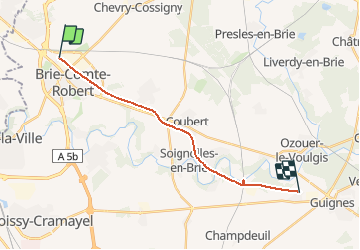
Ruta Senderismo de 15,3 km a descubrir en Isla de Francia, Sena y Marne, Brie-Comte-Robert. Esta ruta ha sido propuesta por Bntg.
Descripción
Pas besoin GPS; une fois sur le chemin il n'y a qu'à suivre.
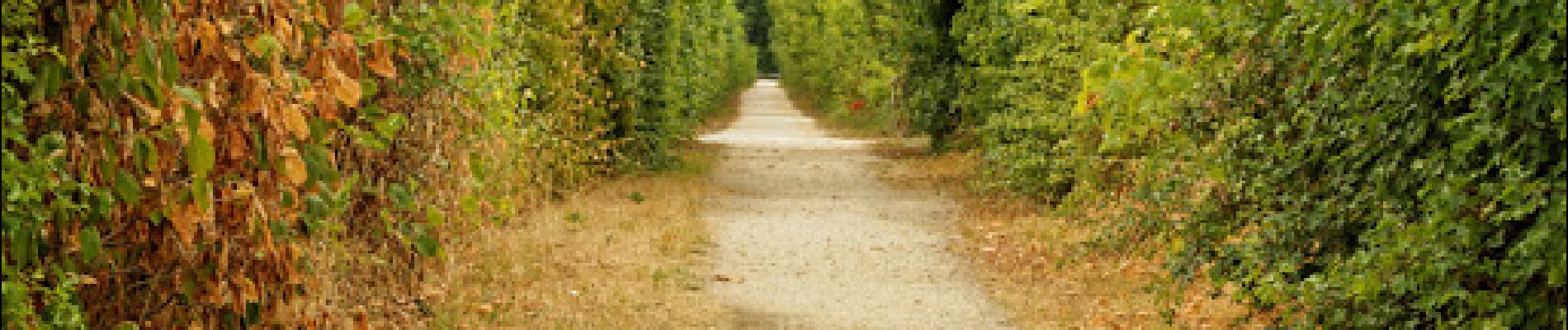
Ancienne voie de chemin de fer acheminant les roses à Paris aménagée en "coulée verte". Pas de difficulté pour les VTC sauf au passage sous la voie TGV (une petite suée pour les VTTistes). Pas de béton à l'horizon sur la majorité du parcours du reste assez monotone (sauf pour celui qui ne sait plus ce que c'est qu'un arbre). Quelques Spot agréables néanmoins : ancienne gare, maison du garde-barrière, passage sur l'Yerres, ...
Un moment agréable pour une promenade de santé.
A noter que les cyclistes accrocs de vitesse devront éviter les dimanches et jours fériés.
Prévoir aller/retour; pas de transport à Yébles.
Localización
Comentarios
Excursiones cerca
![Excursión Senderismo Servon - J 22 12.00 km Lésigny intempéries - Photo](https://media.geolcdn.com/t/375/260/ext.jpg?maxdim=2&url=https%3A%2F%2Fstatic1.geolcdn.com%2Fsiteimages%2Fupload%2Ffiles%2F1553511878bg_sport_marche.png)
![Senderismo Senderismo](https://static1.geolcdn.com/sitytour/trail-icons/101.png)
Senderismo
![](/images/other/stat-length.png)
![](https://static1.geolcdn.com/siteimages/upload/files/16400158638029165_repeat_loop_refresh_sync_direction_icon.png)
![Excursión A pie Villecresnes - L 20 boucle golf villecresnes et ancienne voie de chemin de fer - Photo](https://media.geolcdn.com/t/375/260/ext.jpg?maxdim=2&url=https%3A%2F%2Fstatic1.geolcdn.com%2Fsiteimages%2Fupload%2Ffiles%2F1545311037marcheuse_200dpi.jpg)
![A pie A pie](https://static1.geolcdn.com/sitytour/trail-icons/100.png)
A pie
![](/images/other/stat-length.png)
![](https://static1.geolcdn.com/siteimages/upload/files/16400158638029165_repeat_loop_refresh_sync_direction_icon.png)
![Excursión A pie Servon - nom_fic (49) - Photo](https://media.geolcdn.com/t/375/260/b5894e46-d1cd-485b-a28c-446d5e91d239.jpg&format=jpg&maxdim=2)
![A pie A pie](https://static1.geolcdn.com/sitytour/trail-icons/100.png)
A pie
![](/images/other/stat-length.png)
![](https://static1.geolcdn.com/siteimages/upload/files/16400158638029165_repeat_loop_refresh_sync_direction_icon.png)
![Excursión Senderismo Marolles-en-Brie - GRP CV-IDF 05 - Photo](https://media.geolcdn.com/t/375/260/3f1bdad2-a959-4f32-b201-59b2c8841688.jpg&format=jpg&maxdim=2)
![Senderismo Senderismo](https://static1.geolcdn.com/sitytour/trail-icons/101.png)
Senderismo
![](/images/other/stat-length.png)
![](https://static1.geolcdn.com/siteimages/upload/files/16400158638029165_repeat_loop_refresh_sync_direction_icon.png)
![Excursión Senderismo Mandres-les-Roses - J 26 Mandres, Boussy , Brunoy le chemin des fresques - Photo](https://media.geolcdn.com/t/375/260/a7099e05-5a69-431c-83ab-49f9701f5dd5.jpg&format=jpg&maxdim=2)
![Senderismo Senderismo](https://static1.geolcdn.com/sitytour/trail-icons/101.png)
Senderismo
![](/images/other/stat-length.png)
![](https://static1.geolcdn.com/siteimages/upload/files/16400158638029165_repeat_loop_refresh_sync_direction_icon.png)
![A pie A pie](https://static1.geolcdn.com/sitytour/trail-icons/100.png)
A pie
![](/images/other/stat-length.png)
![](https://static1.geolcdn.com/siteimages/upload/files/16400158638029165_repeat_loop_refresh_sync_direction_icon.png)
![Excursión A pie Servon - R 04 - 8 km - Servon, Santeny, Servon - Photo](https://media.geolcdn.com/t/375/260/b334c7b2-5ac3-4f3d-879c-3237cd85e14e.jpg&format=jpg&maxdim=2)
![A pie A pie](https://static1.geolcdn.com/sitytour/trail-icons/100.png)
A pie
![](/images/other/stat-length.png)
![](https://static1.geolcdn.com/siteimages/upload/files/16400158638029165_repeat_loop_refresh_sync_direction_icon.png)
![Excursión Senderismo Brie-Comte-Robert - brie comte robert - Photo](https://media.geolcdn.com/t/375/260/ext.jpg?maxdim=2&url=https%3A%2F%2Fservices.sitytrail.com%2FGeolivesWS%2FDownloadMedia.ashx%3FTrailID%3D172162%26Media%3D20130130123759.jpeg)
![Senderismo Senderismo](https://static1.geolcdn.com/sitytour/trail-icons/101.png)
Senderismo
![](/images/other/stat-length.png)
![](https://static1.geolcdn.com/siteimages/upload/files/16400158638029165_repeat_loop_refresh_sync_direction_icon.png)
![Excursión Senderismo Servon - JC 24 Servon , Villecresnes, forêt de la Grange - Photo](https://media.geolcdn.com/t/375/260/9e243d85-e3cc-498b-9c48-b6dc55815f83.jpg&format=jpg&maxdim=2)
![Senderismo Senderismo](https://static1.geolcdn.com/sitytour/trail-icons/101.png)
Senderismo
![](/images/other/stat-length.png)
![](https://static1.geolcdn.com/siteimages/upload/files/16400158638029165_repeat_loop_refresh_sync_direction_icon.png)