![](/images/other/stat-length.png)
![Excursión Senderismo Plaintel - Les Mauriers par le chemin des fées. - Photo](https://media.geolcdn.com/t/1900/400/dbc16f7f-f074-4434-9af8-4cba226f873f.jpg&format=pjpeg&maxdim=2)
Les Mauriers par le chemin des fées.
Alphe
Usuario
![Longitud](/images/other/stat-length.png)
![Altitud máxima](https://static1.geolcdn.com/siteimages/upload/files/1508320355ic_sort_altitude_max_24dp.png)
![Desnivel positivo](https://static1.geolcdn.com/siteimages/upload/files/1508320355ic_sort_den_pos_24dp.png)
![Km-Effort](/images/other/stat-length.png)
![Altitud mínima](https://static1.geolcdn.com/siteimages/upload/files/1508320355ic_sort_altitude_min_24dp.png)
![Desnivel negativo](https://static1.geolcdn.com/siteimages/upload/files/1508320355ic_sort_den_neg_24dp.png)
![Boucle](https://static1.geolcdn.com/siteimages/upload/files/16400158638029165_repeat_loop_refresh_sync_direction_icon.png)
![Senderismo](https://static1.geolcdn.com/sitytour/trail-icons/101.png)
1h03
Dificultad : Muy fácil
![Escanee este código QR para abrir la excursión en la aplicación SityTrail](https://capi.geolives.com/qq0zvz2zws4bq2lad0pu/sitytour/trails/2405105/qr.png?size=200)
Aplicación GPS de excursión GRATIS
A propósito
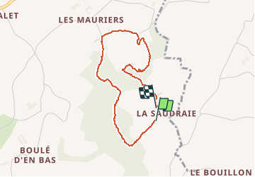
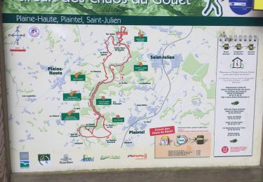
Ruta Senderismo de 3,3 km a descubrir en Bretaña, Côtes-d'Armor, Plaintel. Esta ruta ha sido propuesta por Alphe.
Descripción
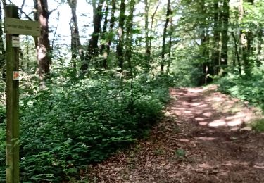
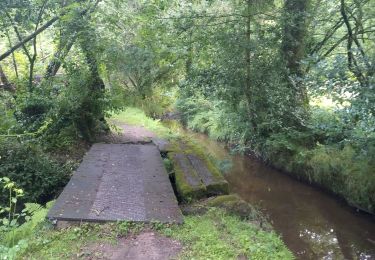
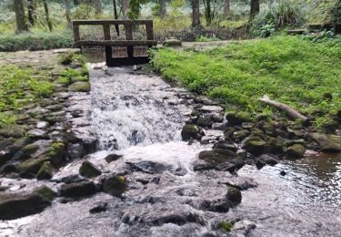
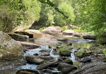
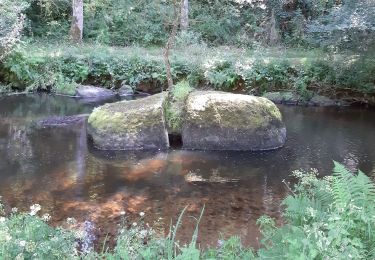
Très belle promenade en sous-bois au départ de la Saudrais. Rejoindre un chemin empieré et le descendre jusqu'au village de Quartier Chanet, prendre a droite jusque
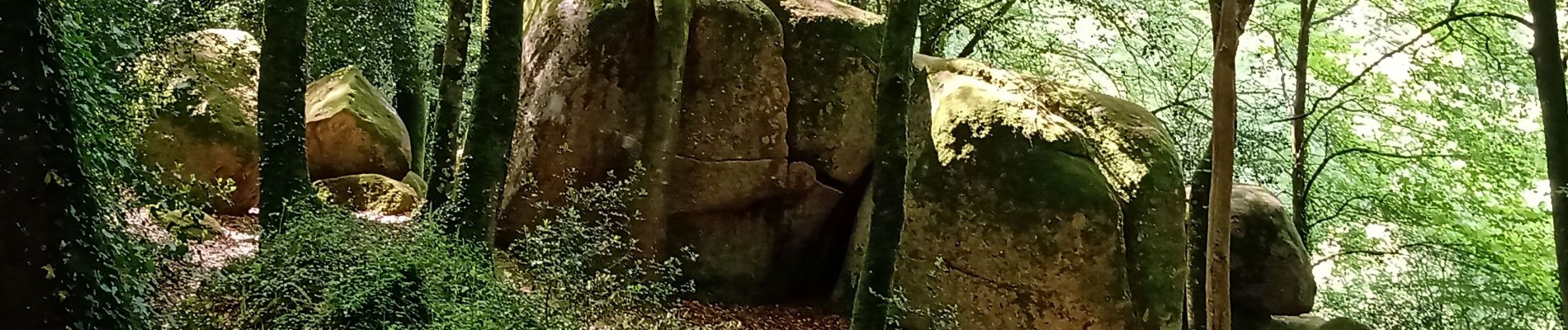
Sur le Moulin, prendre après les premières maisons un sentier qui monte par le chemin des fées (belle curiosité avec les rochers de Margaux). Au bout du sentier tourner à gauche vers la Saudrais.
Localización
Comentarios
Excursiones cerca
![Excursión Senderismo Plédran - En suivant l'URNE et en passant par le BOIS. - Photo](https://media.geolcdn.com/t/375/260/6ac5e845-12d0-4dac-9210-e8525380a84b.jpg&format=jpg&maxdim=2)
![Senderismo Senderismo](https://static1.geolcdn.com/sitytour/trail-icons/101.png)
Senderismo
![](/images/other/stat-length.png)
![](https://static1.geolcdn.com/siteimages/upload/files/16400158638029165_repeat_loop_refresh_sync_direction_icon.png)
![Excursión Cicloturismo Saint-Carreuc - 4 étapes en Bretagne à vélo - Photo](https://media.geolcdn.com/t/375/260/b73d1ea1-a210-439a-a2e4-05e8d782bfa8.jpg&format=jpg&maxdim=2)
![Cicloturismo Cicloturismo](https://static1.geolcdn.com/sitytour/trail-icons/204.png)
Cicloturismo
![](/images/other/stat-length.png)
![](https://static1.geolcdn.com/siteimages/upload/files/16400158638029165_repeat_loop_refresh_sync_direction_icon.png)
![Excursión Senderismo Plaintel - Au bois des Mauriers. N 2 - Photo](https://media.geolcdn.com/t/375/260/fbcf397a-65ed-44d6-9dc4-de1ae1163b15.jpg&format=jpg&maxdim=2)
![Senderismo Senderismo](https://static1.geolcdn.com/sitytour/trail-icons/101.png)
Senderismo
![](/images/other/stat-length.png)
![](https://static1.geolcdn.com/siteimages/upload/files/16400158638029165_repeat_loop_refresh_sync_direction_icon.png)
![Excursión Senderismo Saint-Julien - Bretagne - Saint-Julien - Circuit du Gouët - Photo](https://media.geolcdn.com/t/375/260/f736e7c3-658a-451c-b77e-ab0a790ef18e.jpg&format=jpg&maxdim=2)
![Senderismo Senderismo](https://static1.geolcdn.com/sitytour/trail-icons/101.png)
Senderismo
![](/images/other/stat-length.png)
![](https://static1.geolcdn.com/siteimages/upload/files/16400158638029165_repeat_loop_refresh_sync_direction_icon.png)
![Excursión Carrera Saint-Carreuc - la ville mereuc 1 - Photo](https://media.geolcdn.com/t/375/260/3ad00373-fe78-4964-915b-6e653e4b8a92.jpg&format=jpg&maxdim=2)
![Carrera Carrera](https://static1.geolcdn.com/sitytour/trail-icons/103.png)
Carrera
![](/images/other/stat-length.png)
![](https://static1.geolcdn.com/siteimages/upload/files/16400158638029165_repeat_loop_refresh_sync_direction_icon.png)
![Excursión Senderismo Saint-Julien - Halos du Gouet 21/09/2022 - Photo](https://media.geolcdn.com/t/375/260/8cdf0730-97d8-47a9-a8b5-c336b6e5a271.jpg&format=jpg&maxdim=2)
![Senderismo Senderismo](https://static1.geolcdn.com/sitytour/trail-icons/101.png)
Senderismo
![](/images/other/stat-length.png)
![](https://static1.geolcdn.com/siteimages/upload/files/16400158638029165_repeat_loop_refresh_sync_direction_icon.png)
![Excursión Senderismo Plaintel - Les chaos du gouet - Photo](https://media.geolcdn.com/t/375/260/d2824241-2300-4376-8f89-0eb477b3e02c.jpg&format=jpg&maxdim=2)
![Senderismo Senderismo](https://static1.geolcdn.com/sitytour/trail-icons/101.png)
Senderismo
![](/images/other/stat-length.png)
![](https://static1.geolcdn.com/siteimages/upload/files/16400158638029165_repeat_loop_refresh_sync_direction_icon.png)
![Excursión Senderismo Saint-Julien - clos du gouet - Photo](https://media.geolcdn.com/t/375/260/735dc627-cd60-4fc7-9b7c-a109d90f1a26.jpg&format=jpg&maxdim=2)
![Senderismo Senderismo](https://static1.geolcdn.com/sitytour/trail-icons/101.png)
Senderismo
![](/images/other/stat-length.png)
![](https://static1.geolcdn.com/siteimages/upload/files/16400158638029165_repeat_loop_refresh_sync_direction_icon.png)
![Excursión Bici de montaña Plaine-Haute - chaos du gouet - Photo](https://media.geolcdn.com/t/375/260/ext.jpg?maxdim=2&url=https%3A%2F%2Fstatic1.geolcdn.com%2Fsiteimages%2Fupload%2Ffiles%2F1524743154velo.jpg)
![Bici de montaña Bici de montaña](https://static1.geolcdn.com/sitytour/trail-icons/202.png)
Bici de montaña
![](/images/other/stat-length.png)
![](https://static1.geolcdn.com/siteimages/upload/files/16400158638029165_repeat_loop_refresh_sync_direction_icon.png)