![](/images/other/stat-length.png)
![Excursión Senderismo Samoëns - Lac de Gers - Photo](https://media.geolcdn.com/t/1900/400/ext.pjpeg?maxdim=2&url=https%3A%2F%2Fstatic1.geolcdn.com%2Fsiteimages%2Fupload%2Ffiles%2F1553511878bg_sport_marche.png)
Lac de Gers
petole
Usuario
![Longitud](/images/other/stat-length.png)
Longitud
6,5 km
![Altitud máxima](https://static1.geolcdn.com/siteimages/upload/files/1508320355ic_sort_altitude_max_24dp.png)
Altitud máxima
1537 m
![Desnivel positivo](https://static1.geolcdn.com/siteimages/upload/files/1508320355ic_sort_den_pos_24dp.png)
Desnivel positivo
462 m
![Km-Effort](/images/other/stat-length.png)
Km-Effort
11,3 km
![Altitud mínima](https://static1.geolcdn.com/siteimages/upload/files/1508320355ic_sort_altitude_min_24dp.png)
Altitud mínima
1129 m
![Desnivel negativo](https://static1.geolcdn.com/siteimages/upload/files/1508320355ic_sort_den_neg_24dp.png)
Desnivel negativo
58 m
![Boucle](https://static1.geolcdn.com/siteimages/upload/files/16400158638029165_repeat_loop_refresh_sync_direction_icon.png)
Boucle
No
Fecha de creación :
2020-05-20 08:23:28.0
Última modificación :
2020-05-21 10:15:34.635
![Senderismo](https://static1.geolcdn.com/sitytour/trail-icons/101.png)
2h08
Dificultad : Medio
![Escanee este código QR para abrir la excursión en la aplicación SityTrail](https://capi.geolives.com/qq0zvz2zws4bq2lad0pu/sitytour/trails/2403935/qr.png?size=200)
Aplicación GPS de excursión GRATIS
A propósito
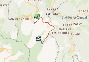
Ruta Senderismo de 6,5 km a descubrir en Auvergne-Rhône-Alpes, Alta Saboya, Samoëns. Esta ruta ha sido propuesta por petole.
Descripción
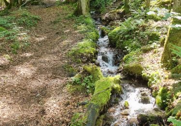
Montée en sous bois par un chemin jeepable. Début un peu pentu puis plus facile. Refuge restaurant au bord du lac
Localización
País:
France
Región :
Auvergne-Rhône-Alpes
Departamento/provincia :
Alta Saboya
Municipio :
Samoëns
Localidad:
Unknown
Salida:(Dec)
Salida:(UTM)
323541 ; 5102180 (32T) N.
Comentarios
Excursiones cerca
![Excursión Senderismo Sixt-Fer-à-Cheval - Lac d'Anterne - Photo](https://media.geolcdn.com/t/375/260/ext.jpg?maxdim=2&url=https%3A%2F%2Fservices.sitytrail.com%2FGeolivesWS%2FDownloadMedia.ashx%3FTrailID%3D219373%26Media%3Dfix__20130905155735.jpg)
![Senderismo Senderismo](https://static1.geolcdn.com/sitytour/trail-icons/101.png)
Lac d'Anterne
Senderismo
Medio
(1)
Sixt-Fer-à-Cheval,
Auvergne-Rhône-Alpes,
Alta Saboya,
France
![](/images/other/stat-length.png)
19,8 km | 37 km-effort
5h 9min
![](https://static1.geolcdn.com/siteimages/upload/files/16400158638029165_repeat_loop_refresh_sync_direction_icon.png)
Sí
![Excursión Senderismo Samoëns - Lac de Gers - Photo](https://media.geolcdn.com/t/375/260/4f8c7a90-c8a6-4a64-bc22-de3fbc680b52.jpg&format=jpg&maxdim=2)
![Senderismo Senderismo](https://static1.geolcdn.com/sitytour/trail-icons/101.png)
Lac de Gers
Senderismo
Fácil
(1)
Samoëns,
Auvergne-Rhône-Alpes,
Alta Saboya,
France
![](/images/other/stat-length.png)
6,7 km | 11,7 km-effort
2h 39min
![](https://static1.geolcdn.com/siteimages/upload/files/16400158638029165_repeat_loop_refresh_sync_direction_icon.png)
No
![Excursión Senderismo Samoëns - Samoens . gorges des tines - retour - Photo](https://media.geolcdn.com/t/375/260/9ca94656-f570-41a8-90f6-cc5f5e98fa82.jpg&format=jpg&maxdim=2)
![Senderismo Senderismo](https://static1.geolcdn.com/sitytour/trail-icons/101.png)
Samoens . gorges des tines - retour
Senderismo
Muy fácil
Samoëns,
Auvergne-Rhône-Alpes,
Alta Saboya,
France
![](/images/other/stat-length.png)
9,6 km | 12,9 km-effort
4h 1min
![](https://static1.geolcdn.com/siteimages/upload/files/16400158638029165_repeat_loop_refresh_sync_direction_icon.png)
Sí
![Excursión Senderismo Sixt-Fer-à-Cheval - Gorges des Tines - Gers - Samoens - Photo](https://media.geolcdn.com/t/375/260/62d4f53d-e161-4e86-b37e-5afda26819a6.jpg&format=jpg&maxdim=2)
![Senderismo Senderismo](https://static1.geolcdn.com/sitytour/trail-icons/101.png)
Gorges des Tines - Gers - Samoens
Senderismo
Difícil
(1)
Sixt-Fer-à-Cheval,
Auvergne-Rhône-Alpes,
Alta Saboya,
France
![](/images/other/stat-length.png)
18,6 km | 33 km-effort
5h 52min
![](https://static1.geolcdn.com/siteimages/upload/files/16400158638029165_repeat_loop_refresh_sync_direction_icon.png)
Sí
![Excursión Senderismo Sixt-Fer-à-Cheval - J9GR5Nord - Photo](https://media.geolcdn.com/t/375/260/425bb134-0523-4921-89e1-6ba98a367abc.jpg&format=jpg&maxdim=2)
![Senderismo Senderismo](https://static1.geolcdn.com/sitytour/trail-icons/101.png)
J9GR5Nord
Senderismo
Muy difícil
Sixt-Fer-à-Cheval,
Auvergne-Rhône-Alpes,
Alta Saboya,
France
![](/images/other/stat-length.png)
16,8 km | 29 km-effort
6h 36min
![](https://static1.geolcdn.com/siteimages/upload/files/16400158638029165_repeat_loop_refresh_sync_direction_icon.png)
No
![Excursión Senderismo Sixt-Fer-à-Cheval - SIXT PASSY RESERVE: CHALETS DE SALES 2 - Photo](https://media.geolcdn.com/t/375/260/8dd95f56-4f3c-4299-950f-2399bed8a605.jpg&format=jpg&maxdim=2)
![Senderismo Senderismo](https://static1.geolcdn.com/sitytour/trail-icons/101.png)
SIXT PASSY RESERVE: CHALETS DE SALES 2
Senderismo
Medio
Sixt-Fer-à-Cheval,
Auvergne-Rhône-Alpes,
Alta Saboya,
France
![](/images/other/stat-length.png)
11,5 km | 21 km-effort
4h 50min
![](https://static1.geolcdn.com/siteimages/upload/files/16400158638029165_repeat_loop_refresh_sync_direction_icon.png)
Sí
![Excursión Senderismo Samoëns - les chalets du Bémont et cascade du Nant d Ant - Photo](https://media.geolcdn.com/t/375/260/70ac3ce4-77a9-4b40-b9e3-5a1ff6333052.jpg&format=jpg&maxdim=2)
![Senderismo Senderismo](https://static1.geolcdn.com/sitytour/trail-icons/101.png)
les chalets du Bémont et cascade du Nant d Ant
Senderismo
Medio
Samoëns,
Auvergne-Rhône-Alpes,
Alta Saboya,
France
![](/images/other/stat-length.png)
6,7 km | 10,5 km-effort
2h 10min
![](https://static1.geolcdn.com/siteimages/upload/files/16400158638029165_repeat_loop_refresh_sync_direction_icon.png)
No
![Excursión Senderismo Morillon - autour de Morillon 74 . - Photo](https://media.geolcdn.com/t/375/260/b4aee69c-0957-47de-81a8-a0b1eee72c00.jpg&format=jpg&maxdim=2)
![Senderismo Senderismo](https://static1.geolcdn.com/sitytour/trail-icons/101.png)
autour de Morillon 74 .
Senderismo
Fácil
Morillon,
Auvergne-Rhône-Alpes,
Alta Saboya,
France
![](/images/other/stat-length.png)
5,9 km | 7,9 km-effort
1h 51min
![](https://static1.geolcdn.com/siteimages/upload/files/16400158638029165_repeat_loop_refresh_sync_direction_icon.png)
Sí
![Excursión Senderismo Sixt-Fer-à-Cheval - SIXT PASSY RESERVE: LE BUET MONTEE VIA GRENAIRON - RETOUR PAR LES FONDS - Photo](https://media.geolcdn.com/t/375/260/37ee0cc7-a301-4565-b950-3c9eefd63255.jpg&format=jpg&maxdim=2)
![Senderismo Senderismo](https://static1.geolcdn.com/sitytour/trail-icons/101.png)
SIXT PASSY RESERVE: LE BUET MONTEE VIA GRENAIRON - RETOUR PAR LES FONDS
Senderismo
Muy difícil
Sixt-Fer-à-Cheval,
Auvergne-Rhône-Alpes,
Alta Saboya,
France
![](/images/other/stat-length.png)
26 km | 56 km-effort
8h 42min
![](https://static1.geolcdn.com/siteimages/upload/files/16400158638029165_repeat_loop_refresh_sync_direction_icon.png)
Sí