![](/images/other/stat-length.png)
![Excursión A pie Saint-Raphaël - Lac de Gourin par Belle Barbe Estérel - Photo](https://media.geolcdn.com/t/1900/400/ext.pjpeg?maxdim=2&url=https%3A%2F%2Fstatic1.geolcdn.com%2Fsiteimages%2Fupload%2Ffiles%2F1545311037marcheuse_200dpi.jpg)
Lac de Gourin par Belle Barbe Estérel
verotrail
Usuario
![Longitud](/images/other/stat-length.png)
Longitud
13 km
![Altitud máxima](https://static1.geolcdn.com/siteimages/upload/files/1508320355ic_sort_altitude_max_24dp.png)
Altitud máxima
246 m
![Desnivel positivo](https://static1.geolcdn.com/siteimages/upload/files/1508320355ic_sort_den_pos_24dp.png)
Desnivel positivo
306 m
![Km-Effort](/images/other/stat-length.png)
Km-Effort
17,1 km
![Altitud mínima](https://static1.geolcdn.com/siteimages/upload/files/1508320355ic_sort_altitude_min_24dp.png)
Altitud mínima
39 m
![Desnivel negativo](https://static1.geolcdn.com/siteimages/upload/files/1508320355ic_sort_den_neg_24dp.png)
Desnivel negativo
305 m
![Boucle](https://static1.geolcdn.com/siteimages/upload/files/16400158638029165_repeat_loop_refresh_sync_direction_icon.png)
Boucle
Sí
Fecha de creación :
2020-05-20 19:15:10.662
Última modificación :
2020-05-20 19:31:07.985
![A pie](https://static1.geolcdn.com/sitytour/trail-icons/100.png)
--
Dificultad : Medio
![Escanee este código QR para abrir la excursión en la aplicación SityTrail](https://capi.geolives.com/qq0zvz2zws4bq2lad0pu/sitytour/trails/2403370/qr.png?size=200)
Aplicación GPS de excursión GRATIS
A propósito
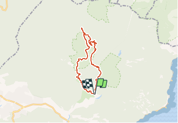
Ruta A pie de 13 km a descubrir en Provenza-Alpes-Costa Azul, Var, Saint-Raphaël. Esta ruta ha sido propuesta por verotrail.
Descripción
Belle barbe, Col Mistral, Pont du Perthus, Pont des Cantines, Col des Suvières, Pain de Sucre, Mamelon de l’Écureuil, Col du Baladou, Col Aubert, Pic du Baladou, Belle Barbe
Localización
País:
France
Región :
Provenza-Alpes-Costa Azul
Departamento/provincia :
Var
Municipio :
Saint-Raphaël
Localidad:
Unknown
Salida:(Dec)
Salida:(UTM)
327587 ; 4813730 (32T) N.
Comentarios
Excursiones cerca
![Excursión Senderismo Saint-Raphaël - Sommet du Bonnet de Capelan - Photo](https://media.geolcdn.com/t/375/260/05863c9a-49da-4f41-9bfb-5d37c8a1781d.jpg&format=jpg&maxdim=2)
![Senderismo Senderismo](https://static1.geolcdn.com/sitytour/trail-icons/101.png)
Sommet du Bonnet de Capelan
Senderismo
Muy difícil
(1)
Saint-Raphaël,
Provenza-Alpes-Costa Azul,
Var,
France
![](/images/other/stat-length.png)
17,7 km | 25 km-effort
4h 40min
![](https://static1.geolcdn.com/siteimages/upload/files/16400158638029165_repeat_loop_refresh_sync_direction_icon.png)
Sí
![Excursión Senderismo Saint-Raphaël - Massif d'ésterel-grande boucle pic cap roux - Photo](https://media.geolcdn.com/t/375/260/75f5531d-898d-4f51-8086-6652c6aad722.jpg&format=jpg&maxdim=2)
![Senderismo Senderismo](https://static1.geolcdn.com/sitytour/trail-icons/101.png)
Massif d'ésterel-grande boucle pic cap roux
Senderismo
Medio
(2)
Saint-Raphaël,
Provenza-Alpes-Costa Azul,
Var,
France
![](/images/other/stat-length.png)
10,4 km | 17,5 km-effort
2h 58min
![](https://static1.geolcdn.com/siteimages/upload/files/16400158638029165_repeat_loop_refresh_sync_direction_icon.png)
Sí
![Excursión Senderismo Saint-Raphaël - Les lacs par les rochers du Caneiret - Photo](https://media.geolcdn.com/t/375/260/cddead80-47f3-4091-93b3-1398b473dc08.jpg&format=jpg&maxdim=2)
![Senderismo Senderismo](https://static1.geolcdn.com/sitytour/trail-icons/101.png)
Les lacs par les rochers du Caneiret
Senderismo
Medio
(1)
Saint-Raphaël,
Provenza-Alpes-Costa Azul,
Var,
France
![](/images/other/stat-length.png)
20 km | 29 km-effort
5h 7min
![](https://static1.geolcdn.com/siteimages/upload/files/16400158638029165_repeat_loop_refresh_sync_direction_icon.png)
Sí
![Excursión Senderismo Saint-Raphaël - le Dramont - Photo](https://media.geolcdn.com/t/375/260/83d1f287-d047-452c-844a-302c6891c476.jpg&format=jpg&maxdim=2)
![Senderismo Senderismo](https://static1.geolcdn.com/sitytour/trail-icons/101.png)
le Dramont
Senderismo
Medio
(2)
Saint-Raphaël,
Provenza-Alpes-Costa Azul,
Var,
France
![](/images/other/stat-length.png)
5,7 km | 8,3 km-effort
2h 32min
![](https://static1.geolcdn.com/siteimages/upload/files/16400158638029165_repeat_loop_refresh_sync_direction_icon.png)
Sí
![Excursión Senderismo Saint-Raphaël - Le tour du Pic du Cap Roux - St Raphaël (Agay) - Photo](https://media.geolcdn.com/t/375/260/ext.jpg?maxdim=2&url=https%3A%2F%2Fservices.sitytrail.com%2FGeolivesWS%2FDownloadMedia.ashx%3FTrailID%3D317929%26Media%3D17353_6.jpg)
![Senderismo Senderismo](https://static1.geolcdn.com/sitytour/trail-icons/101.png)
Le tour du Pic du Cap Roux - St Raphaël (Agay)
Senderismo
Medio
(2)
Saint-Raphaël,
Provenza-Alpes-Costa Azul,
Var,
France
![](/images/other/stat-length.png)
7,2 km | 12,8 km-effort
2h 0min
![](https://static1.geolcdn.com/siteimages/upload/files/16400158638029165_repeat_loop_refresh_sync_direction_icon.png)
Sí
![Excursión Senderismo Saint-Raphaël - Pic du Cap Roux - Photo](https://media.geolcdn.com/t/375/260/ext.jpg?maxdim=2&url=https%3A%2F%2Fservices.sitytrail.com%2FGeolivesWS%2FDownloadMedia.ashx%3FTrailID%3D230669%26Media%3Dfix__20131103111411.jpg)
![Senderismo Senderismo](https://static1.geolcdn.com/sitytour/trail-icons/101.png)
Pic du Cap Roux
Senderismo
Muy fácil
(4)
Saint-Raphaël,
Provenza-Alpes-Costa Azul,
Var,
France
![](/images/other/stat-length.png)
4,1 km | 7,8 km-effort
1h 17min
![](https://static1.geolcdn.com/siteimages/upload/files/16400158638029165_repeat_loop_refresh_sync_direction_icon.png)
Sí
![Excursión Senderismo Saint-Raphaël - SityTrail - ND - Aiguille - Photo](https://media.geolcdn.com/t/375/260/ext.jpg?maxdim=2&url=https%3A%2F%2Fstatic1.geolcdn.com%2Fsiteimages%2Fupload%2Ffiles%2F1553511878bg_sport_marche.png)
![Senderismo Senderismo](https://static1.geolcdn.com/sitytour/trail-icons/101.png)
SityTrail - ND - Aiguille
Senderismo
Muy difícil
(1)
Saint-Raphaël,
Provenza-Alpes-Costa Azul,
Var,
France
![](/images/other/stat-length.png)
18,1 km | 29 km-effort
6h 40min
![](https://static1.geolcdn.com/siteimages/upload/files/16400158638029165_repeat_loop_refresh_sync_direction_icon.png)
Sí
![Excursión Senderismo Saint-Raphaël - Agay - Sainte-Barbe - Étang des Nénuphares - Photo](https://media.geolcdn.com/t/375/260/dfb7073a-02d4-4811-84ba-99dc2878a0d2.jpg&format=jpg&maxdim=2)
![Senderismo Senderismo](https://static1.geolcdn.com/sitytour/trail-icons/101.png)
Agay - Sainte-Barbe - Étang des Nénuphares
Senderismo
Fácil
(2)
Saint-Raphaël,
Provenza-Alpes-Costa Azul,
Var,
France
![](/images/other/stat-length.png)
5 km | 6,2 km-effort
2h 8min
![](https://static1.geolcdn.com/siteimages/upload/files/16400158638029165_repeat_loop_refresh_sync_direction_icon.png)
Sí
![Excursión Senderismo Saint-Raphaël - Tour du Pic de l'Ours - Le Trayas - Photo](https://media.geolcdn.com/t/375/260/ext.jpg?maxdim=2&url=https%3A%2F%2Fservices.sitytrail.com%2FGeolivesWS%2FDownloadMedia.ashx%3FTrailID%3D191486%26Media%3D15078_2.jpg)
![Senderismo Senderismo](https://static1.geolcdn.com/sitytour/trail-icons/101.png)
Tour du Pic de l'Ours - Le Trayas
Senderismo
Medio
(1)
Saint-Raphaël,
Provenza-Alpes-Costa Azul,
Var,
France
![](/images/other/stat-length.png)
9,5 km | 16 km-effort
3h 0min
![](https://static1.geolcdn.com/siteimages/upload/files/16400158638029165_repeat_loop_refresh_sync_direction_icon.png)
Sí