![](/images/other/stat-length.png)
![Excursión Bici de montaña Yenne - En direction du Mt Tournier depuis Yenne - Photo](https://media.geolcdn.com/t/1900/400/ext.pjpeg?maxdim=2&url=https%3A%2F%2Fstatic1.geolcdn.com%2Fsiteimages%2Fupload%2Ffiles%2F1524743154velo.jpg)
En direction du Mt Tournier depuis Yenne
jeannot01
Usuario
![Longitud](/images/other/stat-length.png)
Longitud
18,8 km
![Altitud máxima](https://static1.geolcdn.com/siteimages/upload/files/1508320355ic_sort_altitude_max_24dp.png)
Altitud máxima
599 m
![Desnivel positivo](https://static1.geolcdn.com/siteimages/upload/files/1508320355ic_sort_den_pos_24dp.png)
Desnivel positivo
470 m
![Km-Effort](/images/other/stat-length.png)
Km-Effort
25 km
![Altitud mínima](https://static1.geolcdn.com/siteimages/upload/files/1508320355ic_sort_altitude_min_24dp.png)
Altitud mínima
226 m
![Desnivel negativo](https://static1.geolcdn.com/siteimages/upload/files/1508320355ic_sort_den_neg_24dp.png)
Desnivel negativo
470 m
![Boucle](https://static1.geolcdn.com/siteimages/upload/files/16400158638029165_repeat_loop_refresh_sync_direction_icon.png)
Boucle
Sí
Fecha de creación :
2020-05-20 15:43:49.884
Última modificación :
2020-06-18 06:49:33.668
![Bici de montaña](https://static1.geolcdn.com/sitytour/trail-icons/202.png)
2h01
Dificultad : Muy fácil
![Escanee este código QR para abrir la excursión en la aplicación SityTrail](https://capi.geolives.com/qq0zvz2zws4bq2lad0pu/sitytour/trails/2403261/qr.png?size=200)
Aplicación GPS de excursión GRATIS
A propósito
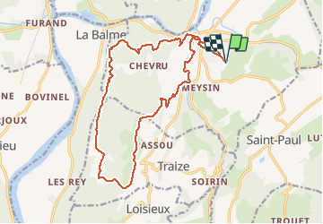
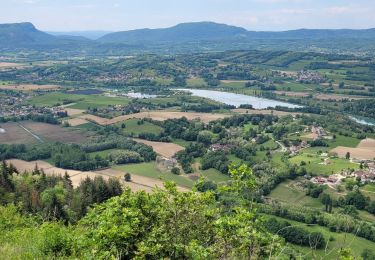
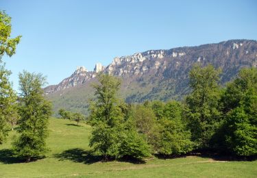
Ruta Bici de montaña de 18,8 km a descubrir en Auvergne-Rhône-Alpes, Saboya, Yenne. Esta ruta ha sido propuesta por jeannot01.
Descripción
Profil en triangle: Ca monte et ça descend!
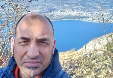
Mais très belle descente, très technique par endroit.
Attention, entre le km 10 et km 12, à certains endroits, il ne faut pas tomber (falaise!)
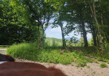
Localización
País:
France
Región :
Auvergne-Rhône-Alpes
Departamento/provincia :
Saboya
Municipio :
Yenne
Localidad:
Unknown
Salida:(Dec)
Salida:(UTM)
715381 ; 5064175 (31T) N.
Comentarios
Excursiones cerca
![Excursión Paseo ecuestre Traize - 202405 Traize boucle 14km - Photo](https://media.geolcdn.com/t/375/260/ffd07fb0-aa84-4dca-b043-f7566568fc44.jpg&format=jpg&maxdim=2)
![Paseo ecuestre Paseo ecuestre](https://static1.geolcdn.com/sitytour/trail-icons/301.png)
202405 Traize boucle 14km
Paseo ecuestre
Medio
(1)
Traize,
Auvergne-Rhône-Alpes,
Saboya,
France
![](/images/other/stat-length.png)
14,2 km | 21 km-effort
3h 30min
![](https://static1.geolcdn.com/siteimages/upload/files/16400158638029165_repeat_loop_refresh_sync_direction_icon.png)
Sí
![Excursión Senderismo Yenne - Balcon de Yenne et Sentier des Belvédères - Photo](https://media.geolcdn.com/t/375/260/ext.jpg?maxdim=2&url=https%3A%2F%2Fservices.sitytrail.com%2FGeolivesWS%2FDownloadMedia.ashx%3FTrailID%3D317936%26Media%3D17363_1.jpg)
![Senderismo Senderismo](https://static1.geolcdn.com/sitytour/trail-icons/101.png)
Balcon de Yenne et Sentier des Belvédères
Senderismo
Fácil
(2)
Yenne,
Auvergne-Rhône-Alpes,
Saboya,
France
![](/images/other/stat-length.png)
13,2 km | 19,4 km-effort
4h 0min
![](https://static1.geolcdn.com/siteimages/upload/files/16400158638029165_repeat_loop_refresh_sync_direction_icon.png)
Sí
![Excursión Senderismo Saint-Jean-de-Chevelu - st jean le chevelu - Photo](https://media.geolcdn.com/t/375/260/f752bdfc-b9bc-4dfb-b673-6eb9a7dfceae.jpg&format=jpg&maxdim=2)
![Senderismo Senderismo](https://static1.geolcdn.com/sitytour/trail-icons/101.png)
st jean le chevelu
Senderismo
Difícil
Saint-Jean-de-Chevelu,
Auvergne-Rhône-Alpes,
Saboya,
France
![](/images/other/stat-length.png)
15,4 km | 23 km-effort
6h 51min
![](https://static1.geolcdn.com/siteimages/upload/files/16400158638029165_repeat_loop_refresh_sync_direction_icon.png)
Sí
![Excursión Senderismo Yenne - parves - Photo](https://media.geolcdn.com/t/375/260/61b87ce1-91e6-4d16-8d94-45e6258d0ccc.jpg&format=jpg&maxdim=2)
![Senderismo Senderismo](https://static1.geolcdn.com/sitytour/trail-icons/101.png)
parves
Senderismo
Muy difícil
Yenne,
Auvergne-Rhône-Alpes,
Saboya,
France
![](/images/other/stat-length.png)
17,4 km | 25 km-effort
6h 59min
![](https://static1.geolcdn.com/siteimages/upload/files/16400158638029165_repeat_loop_refresh_sync_direction_icon.png)
Sí
![Excursión Senderismo Le Bourget-du-Lac - Le Molard du mont du Chat - Photo](https://media.geolcdn.com/t/375/260/ec8abf10-1e1d-496d-bf4f-ea01891581c4.jpg&format=jpg&maxdim=2)
![Senderismo Senderismo](https://static1.geolcdn.com/sitytour/trail-icons/101.png)
Le Molard du mont du Chat
Senderismo
Muy fácil
(1)
Le Bourget-du-Lac,
Auvergne-Rhône-Alpes,
Saboya,
France
![](/images/other/stat-length.png)
3,1 km | 4,5 km-effort
1h 32min
![](https://static1.geolcdn.com/siteimages/upload/files/16400158638029165_repeat_loop_refresh_sync_direction_icon.png)
Sí
![Excursión Bici de carretera Yenne - circuit des vignes Yenne - Photo](https://media.geolcdn.com/t/375/260/2d518aa8-74bd-4e0c-b3e7-110602067d3b.jpg&format=jpg&maxdim=2)
![Bici de carretera Bici de carretera](https://static1.geolcdn.com/sitytour/trail-icons/201.png)
circuit des vignes Yenne
Bici de carretera
Fácil
Yenne,
Auvergne-Rhône-Alpes,
Saboya,
France
![](/images/other/stat-length.png)
32 km | 38 km-effort
1h 53min
![](https://static1.geolcdn.com/siteimages/upload/files/16400158638029165_repeat_loop_refresh_sync_direction_icon.png)
Sí
![Excursión sport Yenne - Y’en en - Photo](https://media.geolcdn.com/t/375/260/7552150f-0035-48b5-8a18-f3113f7c41b3.jpg&format=jpg&maxdim=2)
Y’en en
sport
Muy fácil
Yenne,
Auvergne-Rhône-Alpes,
Saboya,
France
![](/images/other/stat-length.png)
5 km | 5,4 km-effort
Desconocido
![](https://static1.geolcdn.com/siteimages/upload/files/16400158638029165_repeat_loop_refresh_sync_direction_icon.png)
Sí
![Excursión Senderismo Parves-et-Nattages - parves - Photo](https://media.geolcdn.com/t/375/260/d81b99cb-18d1-4e64-a8a8-4aa5dcd0bab6.jpg&format=jpg&maxdim=2)
![Senderismo Senderismo](https://static1.geolcdn.com/sitytour/trail-icons/101.png)
parves
Senderismo
Fácil
Parves-et-Nattages,
Auvergne-Rhône-Alpes,
Ain,
France
![](/images/other/stat-length.png)
3,3 km | 3,9 km-effort
1h 3min
![](https://static1.geolcdn.com/siteimages/upload/files/16400158638029165_repeat_loop_refresh_sync_direction_icon.png)
Sí
![Senderismo Senderismo](https://static1.geolcdn.com/sitytour/trail-icons/101.png)
St-Paul-G1-Boucle des Pins-Boucle de la Manche
Senderismo
Difícil
(1)
Saint-Paul,
Auvergne-Rhône-Alpes,
Saboya,
France
![](/images/other/stat-length.png)
9,1 km | 12,7 km-effort
2h 53min
![](https://static1.geolcdn.com/siteimages/upload/files/16400158638029165_repeat_loop_refresh_sync_direction_icon.png)
Sí