![](/images/other/stat-length.png)
![Excursión Senderismo Osenbach - JD 17/20 Famille Osenbach Wintzfelden Vallée Noble VCourte - Photo](https://media.geolcdn.com/t/1900/400/ext.pjpeg?maxdim=2&url=https%3A%2F%2Fstatic1.geolcdn.com%2Fsiteimages%2Fupload%2Ffiles%2F1553511878bg_sport_marche.png)
JD 17/20 Famille Osenbach Wintzfelden Vallée Noble VCourte
argonneuweg
Usuario
![Longitud](/images/other/stat-length.png)
Longitud
6,3 km
![Altitud máxima](https://static1.geolcdn.com/siteimages/upload/files/1508320355ic_sort_altitude_max_24dp.png)
Altitud máxima
442 m
![Desnivel positivo](https://static1.geolcdn.com/siteimages/upload/files/1508320355ic_sort_den_pos_24dp.png)
Desnivel positivo
171 m
![Km-Effort](/images/other/stat-length.png)
Km-Effort
8,6 km
![Altitud mínima](https://static1.geolcdn.com/siteimages/upload/files/1508320355ic_sort_altitude_min_24dp.png)
Altitud mínima
318 m
![Desnivel negativo](https://static1.geolcdn.com/siteimages/upload/files/1508320355ic_sort_den_neg_24dp.png)
Desnivel negativo
169 m
![Boucle](https://static1.geolcdn.com/siteimages/upload/files/16400158638029165_repeat_loop_refresh_sync_direction_icon.png)
Boucle
Sí
Fecha de creación :
2020-05-17 09:04:00.0
Última modificación :
2020-05-19 12:47:24.149
![Senderismo](https://static1.geolcdn.com/sitytour/trail-icons/101.png)
3h06
Dificultad : Medio
![Escanee este código QR para abrir la excursión en la aplicación SityTrail](https://capi.geolives.com/qq0zvz2zws4bq2lad0pu/sitytour/trails/2399436/qr.png?size=200)
Aplicación GPS de excursión GRATIS
A propósito
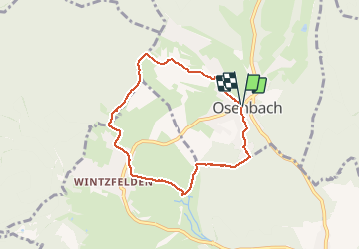
Ruta Senderismo de 6,3 km a descubrir en Gran Este, Alto Rin, Osenbach. Esta ruta ha sido propuesta por argonneuweg.
Descripción
Belle promenade familiale, facile, alternant chemins ouverts et ombragés, dans les très jolis paysages de la vallée noble. Si besoin, choisir le site de la maison forestière au nord de Wintzfelden pour pique-niquer.
Localización
País:
France
Región :
Gran Este
Departamento/provincia :
Alto Rin
Municipio :
Osenbach
Localidad:
Unknown
Salida:(Dec)
Salida:(UTM)
367049 ; 5316228 (32T) N.
Comentarios
Excursiones cerca
![Excursión Senderismo Westhalten - 2021 03 04 Westhalten - Photo](https://media.geolcdn.com/t/375/260/227de508-d68e-430e-b1c3-67de94c52b45.jpg&format=jpg&maxdim=2)
![Senderismo Senderismo](https://static1.geolcdn.com/sitytour/trail-icons/101.png)
2021 03 04 Westhalten
Senderismo
Fácil
(1)
Westhalten,
Gran Este,
Alto Rin,
France
![](/images/other/stat-length.png)
7,7 km | 11,3 km-effort
2h 21min
![](https://static1.geolcdn.com/siteimages/upload/files/16400158638029165_repeat_loop_refresh_sync_direction_icon.png)
Sí
![Senderismo Senderismo](https://static1.geolcdn.com/sitytour/trail-icons/101.png)
Osenbach - Sentier des Sols
Senderismo
Fácil
(1)
Osenbach,
Gran Este,
Alto Rin,
France
![](/images/other/stat-length.png)
4,7 km | 6,6 km-effort
3h 0min
![](https://static1.geolcdn.com/siteimages/upload/files/16400158638029165_repeat_loop_refresh_sync_direction_icon.png)
Sí
![Excursión Senderismo Rouffach - suuntoapp-Hiking-2023-10-22T08-43-15Z - Photo](https://media.geolcdn.com/t/375/260/0163933f-fc15-4bbf-b5e2-ea81260dd156.jpg&format=jpg&maxdim=2)
![Senderismo Senderismo](https://static1.geolcdn.com/sitytour/trail-icons/101.png)
suuntoapp-Hiking-2023-10-22T08-43-15Z
Senderismo
Medio
Rouffach,
Gran Este,
Alto Rin,
France
![](/images/other/stat-length.png)
19 km | 33 km-effort
7h 34min
![](https://static1.geolcdn.com/siteimages/upload/files/16400158638029165_repeat_loop_refresh_sync_direction_icon.png)
Sí
![Excursión Senderismo Westhalten - ND du Hubel_Schauenberg - Photo](https://media.geolcdn.com/t/375/260/ext.jpg?maxdim=2&url=https%3A%2F%2Fstatic1.geolcdn.com%2Fsiteimages%2Fupload%2Ffiles%2F1553511878bg_sport_marche.png)
![Senderismo Senderismo](https://static1.geolcdn.com/sitytour/trail-icons/101.png)
ND du Hubel_Schauenberg
Senderismo
Medio
(2)
Westhalten,
Gran Este,
Alto Rin,
France
![](/images/other/stat-length.png)
8,3 km | 11,7 km-effort
2h 39min
![](https://static1.geolcdn.com/siteimages/upload/files/16400158638029165_repeat_loop_refresh_sync_direction_icon.png)
Sí
![Excursión Senderismo Wasserbourg - Autour de Wasserbourg - Photo](https://media.geolcdn.com/t/375/260/ext.jpg?maxdim=2&url=https%3A%2F%2Fstatic1.geolcdn.com%2Fsiteimages%2Fupload%2Ffiles%2F1553511878bg_sport_marche.png)
![Senderismo Senderismo](https://static1.geolcdn.com/sitytour/trail-icons/101.png)
Autour de Wasserbourg
Senderismo
Fácil
(1)
Wasserbourg,
Gran Este,
Alto Rin,
France
![](/images/other/stat-length.png)
8,8 km | 14 km-effort
2h 6min
![](https://static1.geolcdn.com/siteimages/upload/files/16400158638029165_repeat_loop_refresh_sync_direction_icon.png)
Sí
![Excursión Bici de montaña Westhalten - Westhalten - Le tour de la vallée Noble - Photo](https://media.geolcdn.com/t/375/260/ext.jpg?maxdim=2&url=https%3A%2F%2Fstatic1.geolcdn.com%2Fsiteimages%2Fupload%2Ffiles%2F1524743154velo.jpg)
![Bici de montaña Bici de montaña](https://static1.geolcdn.com/sitytour/trail-icons/202.png)
Westhalten - Le tour de la vallée Noble
Bici de montaña
Difícil
(1)
Westhalten,
Gran Este,
Alto Rin,
France
![](/images/other/stat-length.png)
24 km | 33 km-effort
2h 30min
![](https://static1.geolcdn.com/siteimages/upload/files/16400158638029165_repeat_loop_refresh_sync_direction_icon.png)
Sí
![Excursión Senderismo Pfaffenheim - Marche TL 10/2024 - Parking Chataignier- ND du Schauenburg-Rocher du Coucou-Carrières de Gueberschwihr-Sentier de découvertes- Taverne médiévale-Chapelle St Léonard et retour - Photo](https://media.geolcdn.com/t/375/260/ext.jpg?maxdim=2&url=https%3A%2F%2Fstatic1.geolcdn.com%2Fsiteimages%2Fupload%2Ffiles%2F1553511878bg_sport_marche.png)
![Senderismo Senderismo](https://static1.geolcdn.com/sitytour/trail-icons/101.png)
Marche TL 10/2024 - Parking Chataignier- ND du Schauenburg-Rocher du Coucou-C...
Senderismo
Difícil
(1)
Pfaffenheim,
Gran Este,
Alto Rin,
France
![](/images/other/stat-length.png)
8,5 km | 12,5 km-effort
2h 50min
![](https://static1.geolcdn.com/siteimages/upload/files/16400158638029165_repeat_loop_refresh_sync_direction_icon.png)
Sí
![Excursión Senderismo Gueberschwihr - Gueberschwihr - Voegtlinshoffen - N.-D. de Schauenberg - Pfaffenheim - Photo](https://media.geolcdn.com/t/375/260/57a4399f-f031-43d5-815d-2890d8fbc622.jpg&format=jpg&maxdim=2)
![Senderismo Senderismo](https://static1.geolcdn.com/sitytour/trail-icons/101.png)
Gueberschwihr - Voegtlinshoffen - N.-D. de Schauenberg - Pfaffenheim
Senderismo
Difícil
Gueberschwihr,
Gran Este,
Alto Rin,
France
![](/images/other/stat-length.png)
13,1 km | 18,9 km-effort
4h 17min
![](https://static1.geolcdn.com/siteimages/upload/files/16400158638029165_repeat_loop_refresh_sync_direction_icon.png)
Sí
![Excursión Senderismo Westhalten - WESTHALTEN ZINKOEPHLE - Photo](https://media.geolcdn.com/t/375/260/bb43cbf9-190d-4da9-9235-1bfdec11bc91.jpg&format=jpg&maxdim=2)
![Senderismo Senderismo](https://static1.geolcdn.com/sitytour/trail-icons/101.png)
WESTHALTEN ZINKOEPHLE
Senderismo
Medio
Westhalten,
Gran Este,
Alto Rin,
France
![](/images/other/stat-length.png)
10,6 km | 15,3 km-effort
2h 56min
![](https://static1.geolcdn.com/siteimages/upload/files/16400158638029165_repeat_loop_refresh_sync_direction_icon.png)
Sí