![](/images/other/stat-length.png)
![Excursión Bici de montaña Dorénaz - Dorénaz - Sorniot -Dorénaz - Photo](https://media.geolcdn.com/t/1900/400/ext.pjpeg?maxdim=2&url=https%3A%2F%2Fstatic1.geolcdn.com%2Fsiteimages%2Fupload%2Ffiles%2F1524743154velo.jpg)
Dorénaz - Sorniot -Dorénaz
jokef
Usuario
![Longitud](/images/other/stat-length.png)
![Altitud máxima](https://static1.geolcdn.com/siteimages/upload/files/1508320355ic_sort_altitude_max_24dp.png)
![Desnivel positivo](https://static1.geolcdn.com/siteimages/upload/files/1508320355ic_sort_den_pos_24dp.png)
![Km-Effort](/images/other/stat-length.png)
![Altitud mínima](https://static1.geolcdn.com/siteimages/upload/files/1508320355ic_sort_altitude_min_24dp.png)
![Desnivel negativo](https://static1.geolcdn.com/siteimages/upload/files/1508320355ic_sort_den_neg_24dp.png)
![Boucle](https://static1.geolcdn.com/siteimages/upload/files/16400158638029165_repeat_loop_refresh_sync_direction_icon.png)
![Bici de montaña](https://static1.geolcdn.com/sitytour/trail-icons/202.png)
5h00
Dificultad : Desconocido
![Escanee este código QR para abrir la excursión en la aplicación SityTrail](https://capi.geolives.com/qq0zvz2zws4bq2lad0pu/sitytour/trails/23854/qr.png?size=200)
Aplicación GPS de excursión GRATIS
A propósito
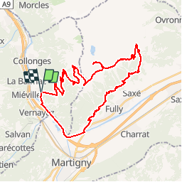
Ruta Bici de montaña de 39 km a descubrir en Vallés, Saint-Maurice, Dorénaz. Esta ruta ha sido propuesta por jokef.
Descripción
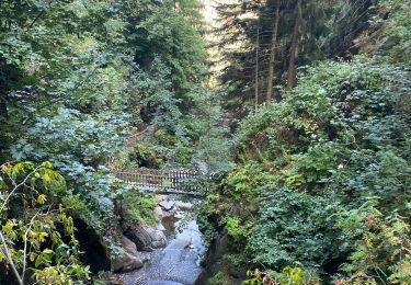
Montée en cabine depuis Dorénaz. La route goudronnée est sans intérêt et on gagne une bonne heure de grimpette.
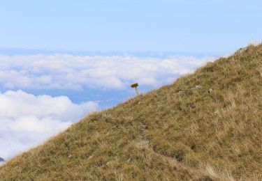
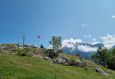
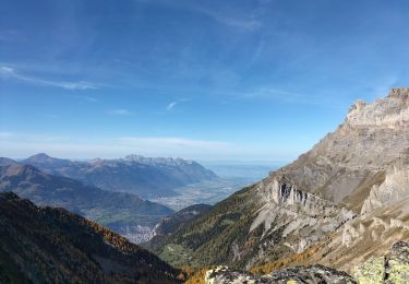
Suivre la route jusqu''à la cabane de Scex Carro pour attraper le chemin à flanc de coteau environ 200m plus haut à gauche. Prendre direction cabane du Demècre, puis direction Portail de Fully. Attention, ça gaze un peu sur le sentier sous le Portail en direction du col de Sorniot. Chute interdite et petit bout à pied conseillé. Idem sous le Chavalard, en direction de l''Erie. Le sentier est de toute beauté avec une vue splendide sur la plaine, mais si vous avez le vertige, ça ne va pas le faire. Attention aussi aux marcheurs qui peuvent être nombreux.
Descente sur Fully par les sentiers du coteau et retour sur Dorénaz en rive gauche.
Plus facilement faisable en deux jours avec une nuit à la cabane de Sorniot (www.chavalard.com).
Localización
Comentarios
Excursiones cerca
![Excursión A pie Martigny - Géoglyphe de Grande Tête - Photo](https://media.geolcdn.com/t/375/260/bef67359-bcde-421e-ab80-f0f245a262d6.jpeg&format=jpg&maxdim=2)
![A pie A pie](https://static1.geolcdn.com/sitytour/trail-icons/100.png)
A pie
![](/images/other/stat-length.png)
![](https://static1.geolcdn.com/siteimages/upload/files/16400158638029165_repeat_loop_refresh_sync_direction_icon.png)
![Excursión A pie Evionnaz - Chemin pédestre, région Martigny - Photo](https://media.geolcdn.com/t/375/260/41342fe9-1951-47cd-bb1b-9e5aff32fd8c.jpeg&format=jpg&maxdim=2)
![A pie A pie](https://static1.geolcdn.com/sitytour/trail-icons/100.png)
A pie
![](/images/other/stat-length.png)
![](https://static1.geolcdn.com/siteimages/upload/files/16400158638029165_repeat_loop_refresh_sync_direction_icon.png)
![Excursión A pie Salvan - Tour du Vallon de Van - Photo](https://media.geolcdn.com/t/375/260/7c24bf3d-9c77-4982-9b22-de277e75b752.jpeg&format=jpg&maxdim=2)
![A pie A pie](https://static1.geolcdn.com/sitytour/trail-icons/100.png)
A pie
![](/images/other/stat-length.png)
![](https://static1.geolcdn.com/siteimages/upload/files/16400158638029165_repeat_loop_refresh_sync_direction_icon.png)
![Excursión A pie Saint-Maurice - Tour des Dents du Midi - Photo](https://media.geolcdn.com/t/375/260/c9928b48-199c-4bc7-84da-28b05ce6686a.jpeg&format=jpg&maxdim=2)
![A pie A pie](https://static1.geolcdn.com/sitytour/trail-icons/100.png)
A pie
![](/images/other/stat-length.png)
![](https://static1.geolcdn.com/siteimages/upload/files/16400158638029165_repeat_loop_refresh_sync_direction_icon.png)
![Excursión Senderismo Saint-Maurice - Tour des dents du midi - Photo](https://media.geolcdn.com/t/375/260/c7faf028-15da-43b6-b1d7-f5582feabc9e.jpg&format=jpg&maxdim=2)
![Senderismo Senderismo](https://static1.geolcdn.com/sitytour/trail-icons/101.png)
Senderismo
![](/images/other/stat-length.png)
![](https://static1.geolcdn.com/siteimages/upload/files/16400158638029165_repeat_loop_refresh_sync_direction_icon.png)
![Excursión Senderismo Dorénaz - le Diabley - Photo](https://media.geolcdn.com/t/375/260/60e318b6-2b8d-4887-8d86-bf3d436e082f.jpg&format=jpg&maxdim=2)
![Senderismo Senderismo](https://static1.geolcdn.com/sitytour/trail-icons/101.png)
Senderismo
![](/images/other/stat-length.png)
![](https://static1.geolcdn.com/siteimages/upload/files/16400158638029165_repeat_loop_refresh_sync_direction_icon.png)
![Excursión Senderismo Salvan - Les gorges à Martigny - Photo](https://media.geolcdn.com/t/375/260/025ef769-e08e-4ddc-a583-500a79aae8e5.jpg&format=jpg&maxdim=2)
![Senderismo Senderismo](https://static1.geolcdn.com/sitytour/trail-icons/101.png)
Senderismo
![](/images/other/stat-length.png)
![](https://static1.geolcdn.com/siteimages/upload/files/16400158638029165_repeat_loop_refresh_sync_direction_icon.png)
![Excursión Senderismo Salvan - Sentier Nature - Rochers du Soir - Photo](https://media.geolcdn.com/t/375/260/ext.jpg?maxdim=2&url=https%3A%2F%2Fstatic1.geolcdn.com%2Fsiteimages%2Fupload%2Ffiles%2F1553511878bg_sport_marche.png)
![Senderismo Senderismo](https://static1.geolcdn.com/sitytour/trail-icons/101.png)
Senderismo
![](/images/other/stat-length.png)
![](https://static1.geolcdn.com/siteimages/upload/files/16400158638029165_repeat_loop_refresh_sync_direction_icon.png)
![Excursión Senderismo Saint-Maurice - Abenteuer-Trek in ein unbekanntes Wallis. Mex - Salanfe (Hotel) - Photo](https://media.geolcdn.com/t/375/260/ext.jpg?maxdim=2&url=https%3A%2F%2Fstatic1.geolcdn.com%2Fsiteimages%2Fupload%2Ffiles%2F1553511878bg_sport_marche.png)
![Senderismo Senderismo](https://static1.geolcdn.com/sitytour/trail-icons/101.png)
Senderismo
![](/images/other/stat-length.png)
![](https://static1.geolcdn.com/siteimages/upload/files/16400158638029165_repeat_loop_refresh_sync_direction_icon.png)