Excursión Senderismo The Municipal District of Cahir — Cashel - Carroll''s Loop - Photo
 mlmoroneybb
mlmoroneybb

Usuario

© OpenStreetMap contributors
Longitud
Longitud
4,5 km
Altitud máxima
Altitud máxima
191 m
Desnivel positivo
Desnivel positivo
104 m
Km-Effort
Km-Effort  
5,9 km
Altitud mínima
Altitud mínima
101 m
Desnivel negativo
Desnivel negativo
100 m
Boucle
Boucle
Fecha de creación :
2014-12-11 00:00:00.0
Última modificación :
2014-12-11 00:00:00.0

(0 Opinión)

Senderismo
Senderismo
1h18
Dificultad : Desconocido

Escanee este código QR para abrir la excursión en la aplicación SityTrail

Aplicación GPS de excursión GRATIS

Logo SityTrail SityTrail

IGN / Institutos geográficos

Descargar SityTrail en App Store Descargar SityTrail en Google Play

Logo SityTrail SityTrail World

El mundo es suyo

Descargar SityTrail en App Store Descargar SityTrail en Google Play Descargar SityTrail en Huawei AppGallery

A propósito

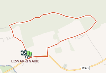
Ruta Senderismo de 4,5 km a descubrir en Desconocido, County Tipperary, The Municipal District of Cahir — Cashel. Esta ruta ha sido propuesta por mlmoroneybb.

Descripción

When William Bulfin, author of Rambles of Eireann, arrived at the top of Slievenamuck and looked down on Lisvarrinane he was completely captivated by what he saw and wrote ??the brightness and freshness of its beauty are entrancing? Those green, swelling, smiling fields, that silver stream, the heather clad slopes of the Galtees, and the thick woods along the northern hills are glorious?

Perfil altimétrico

Localización

País:
Ireland
Región :
Desconocido
Departamento/provincia :
County Tipperary
Municipio :
The Municipal District of Cahir — Cashel
Localidad:
Clonbeg
Salida:(UTM)
552549 ; 5807117 (29U) N.

Excursiones cerca

Excursión Senderismo The Municipal District of Cahir — Cashel - l diheen - Photo
Senderismo
mlmoroneybb

Senderismo

Difícil
The Municipal District of Cahir — Cashel, Desconocido, County Tipperary, Ireland
16,3 km | 32 km-effort
5h 46min
Excursión Senderismo The Municipal District of Cahir — Cashel - Kilross to Lisvarrinane - Photo
Senderismo
mlmoroneybb

Senderismo

Fácil
The Municipal District of Cahir — Cashel, Desconocido, County Tipperary, Ireland
8,5 km | 12 km-effort
2h 34min
No
Excursión Carrera The Municipal District of Cahir — Cashel - Bianconi Loop - Photo
Carrera
mlmoroneybb

Carrera

Fácil
The Municipal District of Cahir — Cashel, Desconocido, County Tipperary, Ireland
3,8 km | 5,3 km-effort
2h 0min
Excursión Carrera The Municipal District of Cahir — Cashel - Ballinacourty Loop - Photo
Carrera
mlmoroneybb

Carrera

Medio
The Municipal District of Cahir — Cashel, Desconocido, County Tipperary, Ireland
8,2 km | 10,9 km-effort
2h 0min
Excursión Carrera The Municipal District of Cahir — Cashel - The Millenium Stone Loop - Photo
Carrera
mlmoroneybb

Carrera

Medio
The Municipal District of Cahir — Cashel, Desconocido, County Tipperary, Ireland
9,4 km | 12,4 km-effort
2h 0min
Excursión Senderismo The Municipal District of Cahir — Cashel - Slievenamuck Walking Marathon Sunday March 24th 2013 - Photo
Senderismo
mlmoroneybb

Senderismo

Difícil
The Municipal District of Cahir — Cashel, Desconocido, County Tipperary, Ireland
42 km | 56 km-effort
11h 36min
No
Excursión Otra actividad The Municipal District of Cahir — Cashel - Kilross - Photo
Otra actividad
mlmoroneybb

Otra actividad

Medio
The Municipal District of Cahir — Cashel, Desconocido, County Tipperary, Ireland
7,9 km | 9,3 km-effort
1h 0min
Excursión Senderismo The Municipal District of Cahir — Cashel - Galtee Walking Club Marathon - Photo
Senderismo
mlmoroneybb

Senderismo

Difícil
The Municipal District of Cahir — Cashel, Desconocido, County Tipperary, Ireland
41 km | 54 km-effort
11h 22min
Excursión Senderismo The Municipal District of Cahir — Cashel - lisvarrinane new - Photo
Senderismo
mlmoroneybb

Senderismo

Fácil
The Municipal District of Cahir — Cashel, Desconocido, County Tipperary, Ireland
4,6 km | 6 km-effort
1h 17min


Cerrar
Mis suscripciones