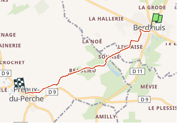
![](/images/other/stat-length.png)
![Excursión Senderismo Berd'huis - SityTrail - Berd'huis - Saint-Cyr-la-Rosière via Préaux-du-Perche 12 km - Photo](https://media.geolcdn.com/t/1900/400/9f597d4c-6499-477b-a914-13f046dbb439.jpg&format=pjpeg&maxdim=2)
SityTrail - Berd'huis - Saint-Cyr-la-Rosière via Préaux-du-Perche 12 km
Traversées Percheronnes
Un maillage d'une centaine de parcours pour composer à la carte sa randonnée itinérante percheronne.
![Longitud](/images/other/stat-length.png)
![Altitud máxima](https://static1.geolcdn.com/siteimages/upload/files/1508320355ic_sort_altitude_max_24dp.png)
![Desnivel positivo](https://static1.geolcdn.com/siteimages/upload/files/1508320355ic_sort_den_pos_24dp.png)
![Km-Effort](/images/other/stat-length.png)
![Altitud mínima](https://static1.geolcdn.com/siteimages/upload/files/1508320355ic_sort_altitude_min_24dp.png)
![Desnivel negativo](https://static1.geolcdn.com/siteimages/upload/files/1508320355ic_sort_den_neg_24dp.png)
![Boucle](https://static1.geolcdn.com/siteimages/upload/files/16400158638029165_repeat_loop_refresh_sync_direction_icon.png)
![Senderismo](https://static1.geolcdn.com/sitytour/trail-icons/101.png)
1h00
Dificultad : Muy fácil
![Escanee este código QR para abrir la excursión en la aplicación SityTrail](https://capi.geolives.com/qq0zvz2zws4bq2lad0pu/sitytour/trails/2379082/qr.png?size=200)
Aplicación GPS de excursión GRATIS
A propósito
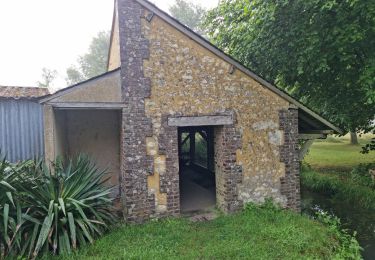
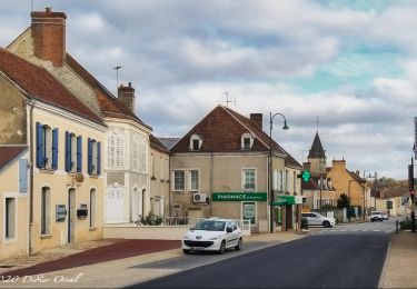
Ruta Senderismo de 4,1 km a descubrir en Normandía, Orne, Berd'huis. Esta ruta ha sido propuesta por Traversées Percheronnes.
Descripción
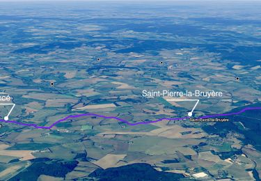
"Traversées Percheronnes" vous propose près de 105 randonnées linéaires organisées en mailles sur le territoire du grand Perche. ?Pour chaque ville ou village étape, nous vous proposons des destinations pouvant être atteintes à pied ou à VTT.?Vous pouvez ainsi composer votre randonnée itinérante à la carte selon le nombre de jours dont vous disposez.... Et des capacités d'hébergement (possibilité de négocier un "taxi" auprès de certaines chambres d’hôtes).?Les topos guides détaillés sont disponible sur le blog de Traversées Percheronnes, hébergé par IGNRando?Site Web : https://ignrando.fr/fr/customer/communaute/index/?
Localización
Comentarios
Excursiones cerca
![Excursión Senderismo Perche en Nocé - Préaux-du-Perche Nord - Photo](https://media.geolcdn.com/t/375/260/a79e2268-207b-49cb-8d2a-d633dd57f73d.jpg&format=jpg&maxdim=2)
![Senderismo Senderismo](https://static1.geolcdn.com/sitytour/trail-icons/101.png)
Senderismo
![](/images/other/stat-length.png)
![](https://static1.geolcdn.com/siteimages/upload/files/16400158638029165_repeat_loop_refresh_sync_direction_icon.png)
![Excursión Senderismo Perche en Nocé - Préaux-du-Perche Sud - Photo](https://media.geolcdn.com/t/375/260/0969c1bf-78c8-4ceb-9cf9-65ed34443adf.jpg&format=jpg&maxdim=2)
![Senderismo Senderismo](https://static1.geolcdn.com/sitytour/trail-icons/101.png)
Senderismo
![](/images/other/stat-length.png)
![](https://static1.geolcdn.com/siteimages/upload/files/16400158638029165_repeat_loop_refresh_sync_direction_icon.png)
![Excursión Senderismo Berd'huis - SityTrail - Berd'huis - Condé-sur-Huisne 14 km - Photo](https://media.geolcdn.com/t/375/260/e562d127-d462-4485-b928-bb7147049073.png&format=jpg&maxdim=2)
![Senderismo Senderismo](https://static1.geolcdn.com/sitytour/trail-icons/101.png)
Senderismo
![](/images/other/stat-length.png)
![](https://static1.geolcdn.com/siteimages/upload/files/16400158638029165_repeat_loop_refresh_sync_direction_icon.png)
![Excursión Senderismo Perche en Nocé - Val d'Enfer 17Km - Photo](https://media.geolcdn.com/t/375/260/285f82a6-4b4a-437a-b428-48270f65e19b.jpg&format=jpg&maxdim=2)
![Senderismo Senderismo](https://static1.geolcdn.com/sitytour/trail-icons/101.png)
Senderismo
![](/images/other/stat-length.png)
![](https://static1.geolcdn.com/siteimages/upload/files/16400158638029165_repeat_loop_refresh_sync_direction_icon.png)
![Excursión Senderismo Perche en Nocé - Nobles logis (Préaux-du-Perche) 9,4Km - Photo](https://media.geolcdn.com/t/375/260/4db8b454-889b-47d7-bd12-5d83e5cd02fb.jpg&format=jpg&maxdim=2)
![Senderismo Senderismo](https://static1.geolcdn.com/sitytour/trail-icons/101.png)
Senderismo
![](/images/other/stat-length.png)
![](https://static1.geolcdn.com/siteimages/upload/files/16400158638029165_repeat_loop_refresh_sync_direction_icon.png)
![Excursión Senderismo Perche en Nocé - Les Panoramas 5,5 Km - Photo](https://media.geolcdn.com/t/375/260/3ecdb278-3826-4aa6-b1de-61f0366a9a2c.jpg&format=jpg&maxdim=2)
![Senderismo Senderismo](https://static1.geolcdn.com/sitytour/trail-icons/101.png)
Senderismo
![](/images/other/stat-length.png)
![](https://static1.geolcdn.com/siteimages/upload/files/16400158638029165_repeat_loop_refresh_sync_direction_icon.png)
![Excursión Senderismo Berd'huis - Bellême - Berd'huis 23 km - Photo](https://media.geolcdn.com/t/375/260/35d6aa94-04a5-460b-b4a9-5d8e7085755b.jpg&format=jpg&maxdim=2)
![Senderismo Senderismo](https://static1.geolcdn.com/sitytour/trail-icons/101.png)
Senderismo
![](/images/other/stat-length.png)
![](https://static1.geolcdn.com/siteimages/upload/files/16400158638029165_repeat_loop_refresh_sync_direction_icon.png)
![Excursión Senderismo Saint-Pierre-la-Bruyère - Condé-sur-Huisne - Saint-Pierre-la-Bruyère via Villeray 8,5 km - Photo](https://media.geolcdn.com/t/375/260/3374e628-d3bf-422a-bb99-175704d9ab1f.jpg&format=jpg&maxdim=2)
![Senderismo Senderismo](https://static1.geolcdn.com/sitytour/trail-icons/101.png)
Senderismo
![](/images/other/stat-length.png)
![](https://static1.geolcdn.com/siteimages/upload/files/16400158638029165_repeat_loop_refresh_sync_direction_icon.png)
![Excursión Senderismo Berd'huis - Berd'huis - Prieuré de Sainte-Gauburge via Préaux-du-Perche 10 km - Photo](https://media.geolcdn.com/t/375/260/2b47d718-7621-44b3-80e6-aa1975b3a7d5.jpg&format=jpg&maxdim=2)
![Senderismo Senderismo](https://static1.geolcdn.com/sitytour/trail-icons/101.png)
Senderismo
![](/images/other/stat-length.png)
![](https://static1.geolcdn.com/siteimages/upload/files/16400158638029165_repeat_loop_refresh_sync_direction_icon.png)