![](/images/other/stat-length.png)
![Excursión Senderismo Loriol-sur-Drôme - De Vaucourte à St Pierre ( Loriol sur Drôme) - Photo](https://media.geolcdn.com/t/1900/400/803fb71c-6251-4f49-b15f-aee45b7892e4.jpg&format=pjpeg&maxdim=2)
De Vaucourte à St Pierre ( Loriol sur Drôme)
crocau
Usuario
![Longitud](/images/other/stat-length.png)
![Altitud máxima](https://static1.geolcdn.com/siteimages/upload/files/1508320355ic_sort_altitude_max_24dp.png)
![Desnivel positivo](https://static1.geolcdn.com/siteimages/upload/files/1508320355ic_sort_den_pos_24dp.png)
![Km-Effort](/images/other/stat-length.png)
![Altitud mínima](https://static1.geolcdn.com/siteimages/upload/files/1508320355ic_sort_altitude_min_24dp.png)
![Desnivel negativo](https://static1.geolcdn.com/siteimages/upload/files/1508320355ic_sort_den_neg_24dp.png)
![Boucle](https://static1.geolcdn.com/siteimages/upload/files/16400158638029165_repeat_loop_refresh_sync_direction_icon.png)
![Senderismo](https://static1.geolcdn.com/sitytour/trail-icons/101.png)
2h10
Dificultad : Muy fácil
![Escanee este código QR para abrir la excursión en la aplicación SityTrail](https://capi.geolives.com/qq0zvz2zws4bq2lad0pu/sitytour/trails/2376549/qr.png?size=200)
Aplicación GPS de excursión GRATIS
A propósito
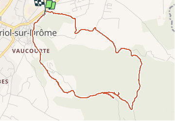
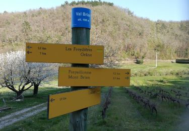
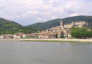
Ruta Senderismo de 5,8 km a descubrir en Auvergne-Rhône-Alpes, Drôme, Loriol-sur-Drôme. Esta ruta ha sido propuesta por crocau.
Descripción
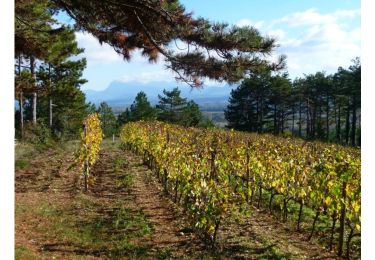
Cette balade permet de partir à pied de Loriol et de traverser le bois de Lagier pour revenir à Loriol.
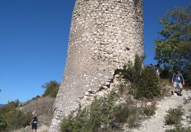
On passe devant le château de Vaucourte du nom de la rivière ( asséchée ?) . Le route devient une route forestière puis un chemin:l faudra donc quitter la route forestière et emprunter un chemin sur la gauche qui monte.
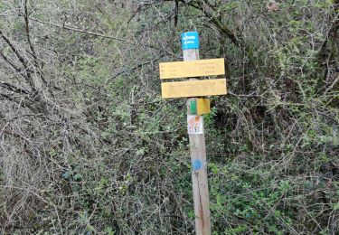
Sur ce chemin , passer devant deux chemins qui partent sur la gauche et prendre le 3 ème qui traversent deux anciennes rivières asséchées. On rejoint le large chemin de Roudignon, puis le chemin des Bois et le chemin de St Pierre.
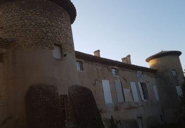
Prendre à droite sur le chemin du clos Chauvin qui semble entrer dans des propriétés privées. On aboutit alors sur un gros portail en fer que l'on contourne par la droite. On parvient ainsi au chemin des Pavillons .
Localización
Comentarios
Excursiones cerca
![Excursión Senderismo Loriol-sur-Drôme - 2023-04-26_18h38m12_Le Pouzin 7km.gpx.xml - Photo](https://media.geolcdn.com/t/375/260/4cf47c0d-a2d0-4de4-99f2-62f2ec02cc1a.jpg&format=jpg&maxdim=2)
![Senderismo Senderismo](https://static1.geolcdn.com/sitytour/trail-icons/101.png)
Senderismo
![](/images/other/stat-length.png)
![](https://static1.geolcdn.com/siteimages/upload/files/16400158638029165_repeat_loop_refresh_sync_direction_icon.png)
![Excursión Senderismo Livron-sur-Drôme - Livron Tour-du-Diable 10km - Photo](https://media.geolcdn.com/t/375/260/32c47bf7-f18d-4008-9d94-058ad16616d9.jpg&format=jpg&maxdim=2)
![Senderismo Senderismo](https://static1.geolcdn.com/sitytour/trail-icons/101.png)
Senderismo
![](/images/other/stat-length.png)
![](https://static1.geolcdn.com/siteimages/upload/files/16400158638029165_repeat_loop_refresh_sync_direction_icon.png)
![Excursión Senderismo Livron-sur-Drôme - 2022-05-31_09h52m35_Livron 7,5km.gpx.xml - Photo](https://media.geolcdn.com/t/375/260/bb0149ec-84c9-4950-b694-78180fdcf5d0.jpg&format=jpg&maxdim=2)
![Senderismo Senderismo](https://static1.geolcdn.com/sitytour/trail-icons/101.png)
Senderismo
![](/images/other/stat-length.png)
![](https://static1.geolcdn.com/siteimages/upload/files/16400158638029165_repeat_loop_refresh_sync_direction_icon.png)
![Excursión Senderismo Grane - De Val Brian au Mont Brian - Photo](https://media.geolcdn.com/t/375/260/bc6d4726-3ae6-481c-b979-5b3a43f540de.jpg&format=jpg&maxdim=2)
![Senderismo Senderismo](https://static1.geolcdn.com/sitytour/trail-icons/101.png)
Senderismo
![](/images/other/stat-length.png)
![](https://static1.geolcdn.com/siteimages/upload/files/16400158638029165_repeat_loop_refresh_sync_direction_icon.png)
![Excursión Senderismo Grane - De Val Brian au lac sans nom - Photo](https://media.geolcdn.com/t/375/260/0dfbfd01-b6ba-4eaf-a75e-fcb6bdc5753b.jpg&format=jpg&maxdim=2)
![Senderismo Senderismo](https://static1.geolcdn.com/sitytour/trail-icons/101.png)
Senderismo
![](/images/other/stat-length.png)
![](https://static1.geolcdn.com/siteimages/upload/files/16400158638029165_repeat_loop_refresh_sync_direction_icon.png)
![Excursión Senderismo Loriol-sur-Drôme - Autour de Blanquinque- Bois de Lagier -Loriol - Photo](https://media.geolcdn.com/t/375/260/6968c12e-da9c-4f6c-b453-84fd58f4e5c0.jpg&format=jpg&maxdim=2)
![Senderismo Senderismo](https://static1.geolcdn.com/sitytour/trail-icons/101.png)
Senderismo
![](/images/other/stat-length.png)
![](https://static1.geolcdn.com/siteimages/upload/files/16400158638029165_repeat_loop_refresh_sync_direction_icon.png)
![Excursión Senderismo La Voulte-sur-Rhône - Printegarde. La Voulte 7km - Photo](https://media.geolcdn.com/t/375/260/9abf1f38-5ddf-4d99-801e-0bc53d9c1b93.jpg&format=jpg&maxdim=2)
![Senderismo Senderismo](https://static1.geolcdn.com/sitytour/trail-icons/101.png)
Senderismo
![](/images/other/stat-length.png)
![](https://static1.geolcdn.com/siteimages/upload/files/16400158638029165_repeat_loop_refresh_sync_direction_icon.png)
![Excursión Senderismo Livron-sur-Drôme - Grane jour 1 - Photo](https://media.geolcdn.com/t/375/260/2a020c8a-8dc3-45bb-88a9-61b770536027.jpg&format=jpg&maxdim=2)
![Senderismo Senderismo](https://static1.geolcdn.com/sitytour/trail-icons/101.png)
Senderismo
![](/images/other/stat-length.png)
![](https://static1.geolcdn.com/siteimages/upload/files/16400158638029165_repeat_loop_refresh_sync_direction_icon.png)
![Excursión Senderismo Loriol-sur-Drôme - Loriol sur Drôme- Château de la Gardette - Photo](https://media.geolcdn.com/t/375/260/faf8a586-5996-4b01-a303-2c5f0613bff7.jpg&format=jpg&maxdim=2)
![Senderismo Senderismo](https://static1.geolcdn.com/sitytour/trail-icons/101.png)
Senderismo
![](/images/other/stat-length.png)
![](https://static1.geolcdn.com/siteimages/upload/files/16400158638029165_repeat_loop_refresh_sync_direction_icon.png)