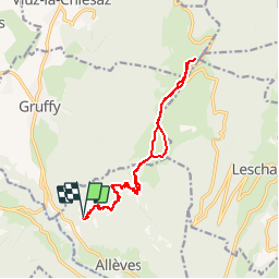
![](/images/other/stat-length.png)
![Excursión Senderismo Allèves - 2013 12 15 Crêt de Chatillon - Photo](https://media.geolcdn.com/t/1900/400/ext.pjpeg?maxdim=2&url=https%3A%2F%2Fstatic1.geolcdn.com%2Fsiteimages%2Fupload%2Ffiles%2F1553511878bg_sport_marche.png)
2013 12 15 Crêt de Chatillon
lechner
Usuario
![Longitud](/images/other/stat-length.png)
![Altitud máxima](https://static1.geolcdn.com/siteimages/upload/files/1508320355ic_sort_altitude_max_24dp.png)
![Desnivel positivo](https://static1.geolcdn.com/siteimages/upload/files/1508320355ic_sort_den_pos_24dp.png)
![Km-Effort](/images/other/stat-length.png)
![Altitud mínima](https://static1.geolcdn.com/siteimages/upload/files/1508320355ic_sort_altitude_min_24dp.png)
![Desnivel negativo](https://static1.geolcdn.com/siteimages/upload/files/1508320355ic_sort_den_neg_24dp.png)
![Boucle](https://static1.geolcdn.com/siteimages/upload/files/16400158638029165_repeat_loop_refresh_sync_direction_icon.png)
![Senderismo](https://static1.geolcdn.com/sitytour/trail-icons/101.png)
5h54
Dificultad : Fácil
![Escanee este código QR para abrir la excursión en la aplicación SityTrail](https://capi.geolives.com/qq0zvz2zws4bq2lad0pu/sitytour/trails/237606/qr.png?size=200)
Aplicación GPS de excursión GRATIS
A propósito
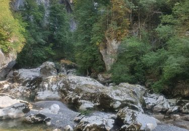
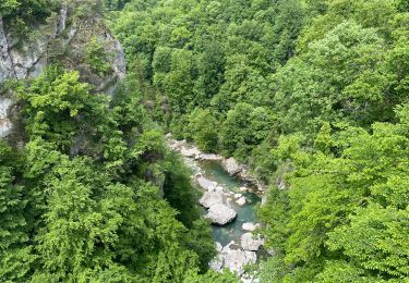
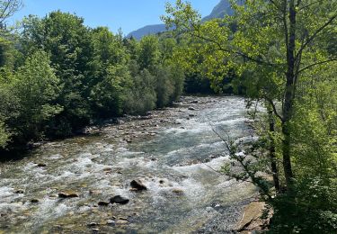
Ruta Senderismo de 15 km a descubrir en Auvergne-Rhône-Alpes, Alta Saboya, Allèves. Esta ruta ha sido propuesta por lechner.
Descripción
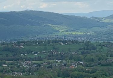
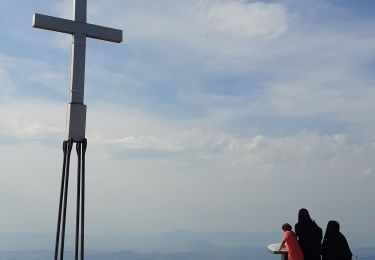
Atteindre en voiture le parking des tours St-Jacques via Cusy. Ensuite, la montée vers les chalets de Gruffy se fait via un chemin bien balisé et sans difficulté particulière. Pause au Crêt de l'aigle face au Mont blanc, puis direction le Crêt de Chatillon pour un magnifique panorama à 360° au milieu des promeneurs (la route est toute proche). L'itinéraire est adapté aux raquettes s'il y a de la neige.
Localización
Comentarios
Excursiones cerca
![Excursión Senderismo Cusy - 13-09-2022 La Grand-Raie au Col de la Cochette - Photo](https://media.geolcdn.com/t/375/260/6cba586f-c088-48b0-8a7d-67e2ef29bd8a.jpg&format=jpg&maxdim=2)
![Senderismo Senderismo](https://static1.geolcdn.com/sitytour/trail-icons/101.png)
Senderismo
![](/images/other/stat-length.png)
![](https://static1.geolcdn.com/siteimages/upload/files/16400158638029165_repeat_loop_refresh_sync_direction_icon.png)
![Excursión Senderismo Allèves - 06-09-2022 Tours Saint Jacques-Grottes de Bange - Photo](https://media.geolcdn.com/t/375/260/7a87734e-615b-4914-a2f6-8cd0e03da331.jpg&format=jpg&maxdim=2)
![Senderismo Senderismo](https://static1.geolcdn.com/sitytour/trail-icons/101.png)
Senderismo
![](/images/other/stat-length.png)
![](https://static1.geolcdn.com/siteimages/upload/files/16400158638029165_repeat_loop_refresh_sync_direction_icon.png)
![Excursión Senderismo Cusy - Les chaos de Cheran - Photo](https://media.geolcdn.com/t/375/260/7e19bf6d-564b-481b-864d-0e6de1762649.jpg&format=jpg&maxdim=2)
![Senderismo Senderismo](https://static1.geolcdn.com/sitytour/trail-icons/101.png)
Senderismo
![](/images/other/stat-length.png)
![](https://static1.geolcdn.com/siteimages/upload/files/16400158638029165_repeat_loop_refresh_sync_direction_icon.png)
![Excursión Senderismo Cusy - Chaos. du Cheran - Photo](https://media.geolcdn.com/t/375/260/ext.jpg?maxdim=2&url=https%3A%2F%2Fstatic1.geolcdn.com%2Fsiteimages%2Fupload%2Ffiles%2F1553511878bg_sport_marche.png)
![Senderismo Senderismo](https://static1.geolcdn.com/sitytour/trail-icons/101.png)
Senderismo
![](/images/other/stat-length.png)
![](https://static1.geolcdn.com/siteimages/upload/files/16400158638029165_repeat_loop_refresh_sync_direction_icon.png)
![Excursión Senderismo Saint-Offenge - Saint-Offenge-Dessous Cusy - Photo](https://media.geolcdn.com/t/375/260/9922806d-4eb0-4835-85fc-26210664b335.jpg&format=jpg&maxdim=2)
![Senderismo Senderismo](https://static1.geolcdn.com/sitytour/trail-icons/101.png)
Senderismo
![](/images/other/stat-length.png)
![](https://static1.geolcdn.com/siteimages/upload/files/16400158638029165_repeat_loop_refresh_sync_direction_icon.png)
![Excursión Senderismo Cusy - 14-08-2022 Pont de Cusy - Pont de l'abîme - Photo](https://media.geolcdn.com/t/375/260/afefb47b-f53a-4dff-bf88-24c102fec5de.jpg&format=jpg&maxdim=2)
![Senderismo Senderismo](https://static1.geolcdn.com/sitytour/trail-icons/101.png)
Senderismo
![](/images/other/stat-length.png)
![](https://static1.geolcdn.com/siteimages/upload/files/16400158638029165_repeat_loop_refresh_sync_direction_icon.png)
![Excursión Senderismo Viuz-la-Chiésaz - Semnoz, mon tour des lacs et des crêts - Photo](https://media.geolcdn.com/t/375/260/783af83e-3511-42c6-b5b4-a812fdab5578.jpg&format=jpg&maxdim=2)
![Senderismo Senderismo](https://static1.geolcdn.com/sitytour/trail-icons/101.png)
Senderismo
![](/images/other/stat-length.png)
![](https://static1.geolcdn.com/siteimages/upload/files/16400158638029165_repeat_loop_refresh_sync_direction_icon.png)
![Excursión Senderismo Cusy - Grosse balade du cheran - Photo](https://media.geolcdn.com/t/375/260/4b4c750e-7c06-406a-b59d-9d7896a078f2.jpg&format=jpg&maxdim=2)
![Senderismo Senderismo](https://static1.geolcdn.com/sitytour/trail-icons/101.png)
Senderismo
![](/images/other/stat-length.png)
![](https://static1.geolcdn.com/siteimages/upload/files/16400158638029165_repeat_loop_refresh_sync_direction_icon.png)
![Excursión Senderismo Cusy - Vers le cheran - Photo](https://media.geolcdn.com/t/375/260/0fcf1c81-bbc6-4eda-956d-4d71d9ae46a9.jpg&format=jpg&maxdim=2)
![Senderismo Senderismo](https://static1.geolcdn.com/sitytour/trail-icons/101.png)
Senderismo
![](/images/other/stat-length.png)
![](https://static1.geolcdn.com/siteimages/upload/files/16400158638029165_repeat_loop_refresh_sync_direction_icon.png)