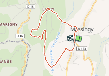
![](/images/other/stat-length.png)
![Excursión Senderismo Massingy - 1 heure - rayon 1 Km Massingy 4 - Photo](https://media.geolcdn.com/t/1900/400/ext.pjpeg?maxdim=2&url=https%3A%2F%2Fstatic1.geolcdn.com%2Fsiteimages%2Fupload%2Ffiles%2F1553511878bg_sport_marche.png)
1 heure - rayon 1 Km Massingy 4
djeepee74
Usuario
![Longitud](/images/other/stat-length.png)
![Altitud máxima](https://static1.geolcdn.com/siteimages/upload/files/1508320355ic_sort_altitude_max_24dp.png)
![Desnivel positivo](https://static1.geolcdn.com/siteimages/upload/files/1508320355ic_sort_den_pos_24dp.png)
![Km-Effort](/images/other/stat-length.png)
![Altitud mínima](https://static1.geolcdn.com/siteimages/upload/files/1508320355ic_sort_altitude_min_24dp.png)
![Desnivel negativo](https://static1.geolcdn.com/siteimages/upload/files/1508320355ic_sort_den_neg_24dp.png)
![Boucle](https://static1.geolcdn.com/siteimages/upload/files/16400158638029165_repeat_loop_refresh_sync_direction_icon.png)
![Senderismo](https://static1.geolcdn.com/sitytour/trail-icons/101.png)
1h00
Dificultad : Fácil
![Escanee este código QR para abrir la excursión en la aplicación SityTrail](https://capi.geolives.com/qq0zvz2zws4bq2lad0pu/sitytour/trails/2373966/qr.png?size=200)
Aplicación GPS de excursión GRATIS
A propósito
Ruta Senderismo de 4,3 km a descubrir en Auvergne-Rhône-Alpes, Alta Saboya, Massingy. Esta ruta ha sido propuesta por djeepee74.
Descripción
BOUCLE... spéciale confinement !
Adaptez la longueur votre sortie et/ou votre vitesse de marche afin de limiter votre périple à 1 heure au maximum... dans un rayon de 1 Km autour de votre domicile.
Par exemple: On peut ne pas descendre "au Péroux" et couper par la Chapelle... dans ce cas le temps estimé et testé est de 52 mn.
Localización
Comentarios
Excursiones cerca
![Excursión Senderismo Massingy - CLERGEON - Photo](https://media.geolcdn.com/t/375/260/ext.jpg?maxdim=2&url=https%3A%2F%2Fservices.sitytrail.com%2FGeolivesWS%2FDownloadMedia.ashx%3FTrailID%3D474185%26Media%3Dc01eb5a7-bf72-4ffc-98fa-1e923f8f3f43.jpg)
![Senderismo Senderismo](https://static1.geolcdn.com/sitytour/trail-icons/101.png)
Senderismo
![](/images/other/stat-length.png)
![](https://static1.geolcdn.com/siteimages/upload/files/16400158638029165_repeat_loop_refresh_sync_direction_icon.png)
![Excursión Senderismo Entrelacs - SAPENAY / CLERGEON: GRANDE CUVE - Photo](https://media.geolcdn.com/t/375/260/81ea709e-f7b9-477c-93c3-923ab4e12c63.jpg&format=jpg&maxdim=2)
![Senderismo Senderismo](https://static1.geolcdn.com/sitytour/trail-icons/101.png)
Senderismo
![](/images/other/stat-length.png)
![](https://static1.geolcdn.com/siteimages/upload/files/16400158638029165_repeat_loop_refresh_sync_direction_icon.png)
![Excursión Senderismo Entrelacs - ERAT 2024 - Photo](https://media.geolcdn.com/t/375/260/e53aa02e-5e29-4cdc-a141-71a7c9a33ac3.jpg&format=jpg&maxdim=2)
![Senderismo Senderismo](https://static1.geolcdn.com/sitytour/trail-icons/101.png)
Senderismo
![](/images/other/stat-length.png)
![](https://static1.geolcdn.com/siteimages/upload/files/16400158638029165_repeat_loop_refresh_sync_direction_icon.png)
![Excursión Senderismo Entrelacs - 26-05-2023 Belvédère de Chambotte - Retour par Saint Germain et Lépau - Photo](https://media.geolcdn.com/t/375/260/21cca317-b85a-47d7-a962-82924b7d629e.jpg&format=jpg&maxdim=2)
![Senderismo Senderismo](https://static1.geolcdn.com/sitytour/trail-icons/101.png)
Senderismo
![](/images/other/stat-length.png)
![](https://static1.geolcdn.com/siteimages/upload/files/16400158638029165_repeat_loop_refresh_sync_direction_icon.png)
![Excursión Senderismo Entrelacs - Ronde des fours Albens - Photo](https://media.geolcdn.com/t/375/260/f2666e0b-68cf-4aa4-9713-51600128943f.jpg&format=jpg&maxdim=2)
![Senderismo Senderismo](https://static1.geolcdn.com/sitytour/trail-icons/101.png)
Senderismo
![](/images/other/stat-length.png)
![](https://static1.geolcdn.com/siteimages/upload/files/16400158638029165_repeat_loop_refresh_sync_direction_icon.png)
![Excursión Senderismo Entrelacs - La Biolle et Albens - Photo](https://media.geolcdn.com/t/375/260/54787595-584f-43aa-94b8-b759dd22b064.jpg&format=jpg&maxdim=2)
![Senderismo Senderismo](https://static1.geolcdn.com/sitytour/trail-icons/101.png)
Senderismo
![](/images/other/stat-length.png)
![](https://static1.geolcdn.com/siteimages/upload/files/16400158638029165_repeat_loop_refresh_sync_direction_icon.png)
![Excursión Senderismo Entrelacs - Tour d’albens - Photo](https://media.geolcdn.com/t/375/260/31c68e67-710d-4c38-ab3f-955ee8ff9617.jpg&format=jpg&maxdim=2)
![Senderismo Senderismo](https://static1.geolcdn.com/sitytour/trail-icons/101.png)
Senderismo
![](/images/other/stat-length.png)
![](https://static1.geolcdn.com/siteimages/upload/files/16400158638029165_repeat_loop_refresh_sync_direction_icon.png)
![Excursión Senderismo Entrelacs - Ptit tour Albens - Photo](https://media.geolcdn.com/t/375/260/416e9181-dd27-4917-bea8-f883a2086a2a.jpg&format=jpg&maxdim=2)
![Senderismo Senderismo](https://static1.geolcdn.com/sitytour/trail-icons/101.png)
Senderismo
![](/images/other/stat-length.png)
![](https://static1.geolcdn.com/siteimages/upload/files/16400158638029165_repeat_loop_refresh_sync_direction_icon.png)
![Excursión Senderismo Chindrieux - SAPENAY / CLERGEON: COL DU SAPENAY - ROJUX - GRANDE CUVE - MONTCLERGEON - Photo](https://media.geolcdn.com/t/375/260/ec0fabdb-a998-4b52-ac46-d11021fde1e5.jpg&format=jpg&maxdim=2)
![Senderismo Senderismo](https://static1.geolcdn.com/sitytour/trail-icons/101.png)
Senderismo
![](/images/other/stat-length.png)
![](https://static1.geolcdn.com/siteimages/upload/files/16400158638029165_repeat_loop_refresh_sync_direction_icon.png)