![](/images/other/stat-length.png)
![Excursión Otra actividad Conthey - VS - Mt-Gond S/Conthey - Photo](https://media.geolcdn.com/t/1900/400/ext.pjpeg?maxdim=2&url=https%3A%2F%2Fstatic1.geolcdn.com%2Fsiteimages%2Fupload%2Ffiles%2F1545311037marcheuse_200dpi.jpg)
VS - Mt-Gond S/Conthey
sterrettaz
Usuario
![Longitud](/images/other/stat-length.png)
Longitud
10,9 km
![Altitud máxima](https://static1.geolcdn.com/siteimages/upload/files/1508320355ic_sort_altitude_max_24dp.png)
Altitud máxima
2569 m
![Desnivel positivo](https://static1.geolcdn.com/siteimages/upload/files/1508320355ic_sort_den_pos_24dp.png)
Desnivel positivo
1238 m
![Km-Effort](/images/other/stat-length.png)
Km-Effort
27 km
![Altitud mínima](https://static1.geolcdn.com/siteimages/upload/files/1508320355ic_sort_altitude_min_24dp.png)
Altitud mínima
1321 m
![Desnivel negativo](https://static1.geolcdn.com/siteimages/upload/files/1508320355ic_sort_den_neg_24dp.png)
Desnivel negativo
1231 m
![Boucle](https://static1.geolcdn.com/siteimages/upload/files/16400158638029165_repeat_loop_refresh_sync_direction_icon.png)
Boucle
Sí
Fecha de creación :
2014-12-11 00:00:00.0
Última modificación :
2014-12-11 00:00:00.0
![Otra actividad](https://static1.geolcdn.com/sitytour/trail-icons/900.png)
--
Dificultad : Desconocido
![Escanee este código QR para abrir la excursión en la aplicación SityTrail](https://capi.geolives.com/qq0zvz2zws4bq2lad0pu/sitytour/trails/23681/qr.png?size=200)
Aplicación GPS de excursión GRATIS
A propósito
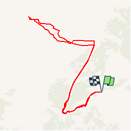
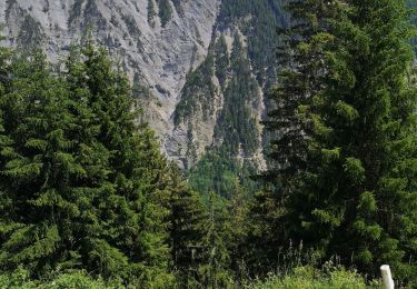
Ruta Otra actividad de 10,9 km a descubrir en Vallés, Conthey, Conthey. Esta ruta ha sido propuesta por sterrettaz.
Descripción
Col à l''ouest du Mont Gond,
Superbe point de vue, montée avec Ben G-C.
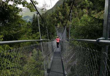
Superbe descente
PS Le même jour que Jy dans la face N du bec d''Orzival!
Localización
País:
Switzerland
Región :
Vallés
Departamento/provincia :
Conthey
Municipio :
Conthey
Localidad:
Unknown
Salida:(Dec)
Salida:(UTM)
368304 ; 5124677 (32T) N.
Comentarios
Excursiones cerca
![Excursión A pie Savièse - Bisse de Savièse (Torrent-Neuf) - Photo](https://media.geolcdn.com/t/375/260/2abdaf10-00a9-4b07-a19f-cc4e4efb285c.jpeg&format=jpg&maxdim=2)
![A pie A pie](https://static1.geolcdn.com/sitytour/trail-icons/100.png)
Bisse de Savièse (Torrent-Neuf)
A pie
Fácil
Savièse,
Vallés,
Sion,
Switzerland
![](/images/other/stat-length.png)
4,5 km | 7,4 km-effort
1h 41min
![](https://static1.geolcdn.com/siteimages/upload/files/16400158638029165_repeat_loop_refresh_sync_direction_icon.png)
No
![Excursión Senderismo Savièse - Mayen de la Zour-Prabé - Photo](https://media.geolcdn.com/t/375/260/ext.jpg?maxdim=2&url=https%3A%2F%2Fstatic1.geolcdn.com%2Fsiteimages%2Fupload%2Ffiles%2F1553511878bg_sport_marche.png)
![Senderismo Senderismo](https://static1.geolcdn.com/sitytour/trail-icons/101.png)
Mayen de la Zour-Prabé
Senderismo
Muy fácil
(1)
Savièse,
Vallés,
Sion,
Switzerland
![](/images/other/stat-length.png)
3,8 km | 10,3 km-effort
Desconocido
![](https://static1.geolcdn.com/siteimages/upload/files/16400158638029165_repeat_loop_refresh_sync_direction_icon.png)
No
![Excursión A pie Conthey - Bisse de la Tsandra - Photo](https://media.geolcdn.com/t/375/260/1657d19d-aa60-4f9b-8a51-722366c997ed.jpeg&format=jpg&maxdim=2)
![A pie A pie](https://static1.geolcdn.com/sitytour/trail-icons/100.png)
Bisse de la Tsandra
A pie
Fácil
Conthey,
Vallés,
Conthey,
Switzerland
![](/images/other/stat-length.png)
7,4 km | 10,5 km-effort
2h 23min
![](https://static1.geolcdn.com/siteimages/upload/files/16400158638029165_repeat_loop_refresh_sync_direction_icon.png)
No
![Excursión Senderismo Savièse - bises de torrent neuf - Photo](https://media.geolcdn.com/t/375/260/1deb4bd3-f63a-40cf-92d1-fa0b5d331200.jpg&format=jpg&maxdim=2)
![Senderismo Senderismo](https://static1.geolcdn.com/sitytour/trail-icons/101.png)
bises de torrent neuf
Senderismo
Medio
Savièse,
Vallés,
Sion,
Switzerland
![](/images/other/stat-length.png)
9,9 km | 16 km-effort
4h 12min
![](https://static1.geolcdn.com/siteimages/upload/files/16400158638029165_repeat_loop_refresh_sync_direction_icon.png)
Sí
![Excursión Marcha nórdica Savièse - bini - Photo](https://media.geolcdn.com/t/375/260/7e9efda6-de74-4d67-b090-c299455c4c6c.jpg&format=jpg&maxdim=2)
![Marcha nórdica Marcha nórdica](https://static1.geolcdn.com/sitytour/trail-icons/102.png)
bini
Marcha nórdica
Muy fácil
Savièse,
Vallés,
Sion,
Switzerland
![](/images/other/stat-length.png)
8,9 km | 12,2 km-effort
2h 59min
![](https://static1.geolcdn.com/siteimages/upload/files/16400158638029165_repeat_loop_refresh_sync_direction_icon.png)
No
![Excursión Otra actividad Conthey - st_bg_conthey - Photo](https://media.geolcdn.com/t/375/260/ext.jpg?maxdim=2&url=https%3A%2F%2Fstatic1.geolcdn.com%2Fsiteimages%2Fupload%2Ffiles%2F1545311037marcheuse_200dpi.jpg)
![Otra actividad Otra actividad](https://static1.geolcdn.com/sitytour/trail-icons/900.png)
st_bg_conthey
Otra actividad
Muy fácil
Conthey,
Vallés,
Conthey,
Switzerland
![](/images/other/stat-length.png)
22 km | 42 km-effort
9h 21min
![](https://static1.geolcdn.com/siteimages/upload/files/16400158638029165_repeat_loop_refresh_sync_direction_icon.png)
No
![Excursión Marcha nórdica Conthey - la standra - Photo](https://media.geolcdn.com/t/375/260/00971888-004e-4b79-8e4c-f2fdc10fd21c.jpg&format=jpg&maxdim=2)
![Marcha nórdica Marcha nórdica](https://static1.geolcdn.com/sitytour/trail-icons/102.png)
la standra
Marcha nórdica
Muy fácil
Conthey,
Vallés,
Conthey,
Switzerland
![](/images/other/stat-length.png)
8,2 km | 12 km-effort
2h 41min
![](https://static1.geolcdn.com/siteimages/upload/files/16400158638029165_repeat_loop_refresh_sync_direction_icon.png)
Sí
![Senderismo Senderismo](https://static1.geolcdn.com/sitytour/trail-icons/101.png)
Trajet du 29.10.21
Senderismo
Muy difícil
Conthey,
Vallés,
Conthey,
Switzerland
![](/images/other/stat-length.png)
19,5 km | 38 km-effort
8h 42min
![](https://static1.geolcdn.com/siteimages/upload/files/16400158638029165_repeat_loop_refresh_sync_direction_icon.png)
Sí
![Excursión Senderismo Savièse - bisse du Torrent-Neuf - Photo](https://media.geolcdn.com/t/375/260/8664d117-a28d-4924-865d-a416ce8635bd.jpg&format=jpg&maxdim=2)
![Senderismo Senderismo](https://static1.geolcdn.com/sitytour/trail-icons/101.png)
bisse du Torrent-Neuf
Senderismo
Muy difícil
Savièse,
Vallés,
Sion,
Switzerland
![](/images/other/stat-length.png)
12 km | 19,2 km-effort
4h 52min
![](https://static1.geolcdn.com/siteimages/upload/files/16400158638029165_repeat_loop_refresh_sync_direction_icon.png)
Sí