![](/images/other/stat-length.png)
![Excursión Senderismo Entrelacs - CORSUET: CHAMBOTTE - MEYRIEUX... au plus court ! - Photo](https://media.geolcdn.com/t/1900/400/ext.pjpeg?maxdim=2&url=https%3A%2F%2Fstatic1.geolcdn.com%2Fsiteimages%2Fupload%2Ffiles%2F1553511878bg_sport_marche.png)
CORSUET: CHAMBOTTE - MEYRIEUX... au plus court !
djeepee74
Usuario
![Longitud](/images/other/stat-length.png)
Longitud
9,4 km
![Altitud máxima](https://static1.geolcdn.com/siteimages/upload/files/1508320355ic_sort_altitude_max_24dp.png)
Altitud máxima
846 m
![Desnivel positivo](https://static1.geolcdn.com/siteimages/upload/files/1508320355ic_sort_den_pos_24dp.png)
Desnivel positivo
283 m
![Km-Effort](/images/other/stat-length.png)
Km-Effort
13,2 km
![Altitud mínima](https://static1.geolcdn.com/siteimages/upload/files/1508320355ic_sort_altitude_min_24dp.png)
Altitud mínima
642 m
![Desnivel negativo](https://static1.geolcdn.com/siteimages/upload/files/1508320355ic_sort_den_neg_24dp.png)
Desnivel negativo
281 m
![Boucle](https://static1.geolcdn.com/siteimages/upload/files/16400158638029165_repeat_loop_refresh_sync_direction_icon.png)
Boucle
Sí
Fecha de creación :
2020-03-15 12:34:05.081
Última modificación :
2020-03-15 17:20:39.085
![Senderismo](https://static1.geolcdn.com/sitytour/trail-icons/101.png)
2h30
Dificultad : Fácil
![Escanee este código QR para abrir la excursión en la aplicación SityTrail](https://capi.geolives.com/qq0zvz2zws4bq2lad0pu/sitytour/trails/2365147/qr.png?size=200)
Aplicación GPS de excursión GRATIS
A propósito
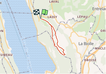
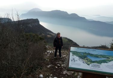
Ruta Senderismo de 9,4 km a descubrir en Auvergne-Rhône-Alpes, Saboya, Entrelacs. Esta ruta ha sido propuesta por djeepee74.
Descripción
Idéal pour un "décrassage" !
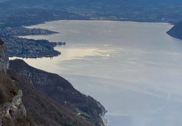
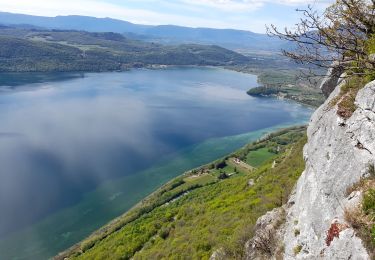
On débouche sur le sentier des crêtes à 250 m. au nord / ouest de la nouvelle croix du Meyrieux.
Localización
País:
France
Región :
Auvergne-Rhône-Alpes
Departamento/provincia :
Saboya
Municipio :
Entrelacs
Localidad:
Saint-Germain-la-Chambotte
Salida:(Dec)
Salida:(UTM)
723490 ; 5073290 (31T) N.
Comentarios
Excursiones cerca
![Excursión Senderismo Chindrieux - Sur les Pas des Huguenots - Chindrieux - Serrières en Chautagne - Photo](https://media.geolcdn.com/t/375/260/ext.jpg?maxdim=2&url=https%3A%2F%2Fservices.sitytrail.com%2FGeolivesWS%2FDownloadMedia.ashx%3FTrailID%3D129664%26Media%3D13193_3.jpg)
![Senderismo Senderismo](https://static1.geolcdn.com/sitytour/trail-icons/101.png)
Sur les Pas des Huguenots - Chindrieux - Serrières en Chautagne
Senderismo
Medio
(1)
Chindrieux,
Auvergne-Rhône-Alpes,
Saboya,
France
![](/images/other/stat-length.png)
9,2 km | 13,8 km-effort
3h 0min
![](https://static1.geolcdn.com/siteimages/upload/files/16400158638029165_repeat_loop_refresh_sync_direction_icon.png)
No
![Excursión Senderismo Entrelacs - 30-08-2022 La Chambotte - Croix de Meyrieu - Photo](https://media.geolcdn.com/t/375/260/c8704b3f-8048-446a-89ef-a79ba6fd2504.jpg&format=jpg&maxdim=2)
![Senderismo Senderismo](https://static1.geolcdn.com/sitytour/trail-icons/101.png)
30-08-2022 La Chambotte - Croix de Meyrieu
Senderismo
Medio
Entrelacs,
Auvergne-Rhône-Alpes,
Saboya,
France
![](/images/other/stat-length.png)
12 km | 19 km-effort
3h 6min
![](https://static1.geolcdn.com/siteimages/upload/files/16400158638029165_repeat_loop_refresh_sync_direction_icon.png)
Sí
![Excursión Senderismo Entrelacs - Belvédère de la Chambotte - Mont de Corsuet - Photo](https://media.geolcdn.com/t/375/260/320ab627-8a91-46ea-b3a7-34db91702556.jpg&format=jpg&maxdim=2)
![Senderismo Senderismo](https://static1.geolcdn.com/sitytour/trail-icons/101.png)
Belvédère de la Chambotte - Mont de Corsuet
Senderismo
Medio
(1)
Entrelacs,
Auvergne-Rhône-Alpes,
Saboya,
France
![](/images/other/stat-length.png)
6,9 km | 10,1 km-effort
2h 18min
![](https://static1.geolcdn.com/siteimages/upload/files/16400158638029165_repeat_loop_refresh_sync_direction_icon.png)
Sí
![Excursión Senderismo Entrelacs - La chambotte mont laval aix les bains - Photo](https://media.geolcdn.com/t/375/260/83780321-69f1-4ca1-9229-55e6ffa1c410.jpg&format=jpg&maxdim=2)
![Senderismo Senderismo](https://static1.geolcdn.com/sitytour/trail-icons/101.png)
La chambotte mont laval aix les bains
Senderismo
Fácil
Entrelacs,
Auvergne-Rhône-Alpes,
Saboya,
France
![](/images/other/stat-length.png)
5,6 km | 8,9 km-effort
2h 24min
![](https://static1.geolcdn.com/siteimages/upload/files/16400158638029165_repeat_loop_refresh_sync_direction_icon.png)
Sí
![Excursión Senderismo Entrelacs - Bellevedere de la Chambotte - Photo](https://media.geolcdn.com/t/375/260/69045582-c557-4058-9efb-585a49f48118.jpg&format=jpg&maxdim=2)
![Senderismo Senderismo](https://static1.geolcdn.com/sitytour/trail-icons/101.png)
Bellevedere de la Chambotte
Senderismo
Muy difícil
Entrelacs,
Auvergne-Rhône-Alpes,
Saboya,
France
![](/images/other/stat-length.png)
12,4 km | 19 km-effort
3h 37min
![](https://static1.geolcdn.com/siteimages/upload/files/16400158638029165_repeat_loop_refresh_sync_direction_icon.png)
Sí
![Excursión Senderismo La Biolle - La Biolle - Photo](https://media.geolcdn.com/t/375/260/fe7a0a14-cbca-4a8d-bceb-b57e7cb64bdc.jpg&format=jpg&maxdim=2)
![Senderismo Senderismo](https://static1.geolcdn.com/sitytour/trail-icons/101.png)
La Biolle
Senderismo
Difícil
La Biolle,
Auvergne-Rhône-Alpes,
Saboya,
France
![](/images/other/stat-length.png)
12 km | 15,1 km-effort
4h 20min
![](https://static1.geolcdn.com/siteimages/upload/files/16400158638029165_repeat_loop_refresh_sync_direction_icon.png)
Sí
![Excursión Senderismo Entrelacs - CHAMBOTTE: DECRASSAGE SUR LES CRETES - Photo](https://media.geolcdn.com/t/375/260/ddde69c3-3462-4077-ba6c-e835ee2db56d.jpg&format=jpg&maxdim=2)
![Senderismo Senderismo](https://static1.geolcdn.com/sitytour/trail-icons/101.png)
CHAMBOTTE: DECRASSAGE SUR LES CRETES
Senderismo
Fácil
Entrelacs,
Auvergne-Rhône-Alpes,
Saboya,
France
![](/images/other/stat-length.png)
5,8 km | 9,4 km-effort
2h 0min
![](https://static1.geolcdn.com/siteimages/upload/files/16400158638029165_repeat_loop_refresh_sync_direction_icon.png)
Sí
![Excursión Senderismo Entrelacs - SAPENAY: MONTAGNE DE CESSENS - Photo](https://media.geolcdn.com/t/375/260/cae53790-ce06-4ff8-a857-f0d1206d4970.jpg&format=jpg&maxdim=2)
![Senderismo Senderismo](https://static1.geolcdn.com/sitytour/trail-icons/101.png)
SAPENAY: MONTAGNE DE CESSENS
Senderismo
Fácil
Entrelacs,
Auvergne-Rhône-Alpes,
Saboya,
France
![](/images/other/stat-length.png)
7,9 km | 12,2 km-effort
2h 35min
![](https://static1.geolcdn.com/siteimages/upload/files/16400158638029165_repeat_loop_refresh_sync_direction_icon.png)
Sí
![Excursión Senderismo Brison-Saint-Innocent - grotte Aux fées et Croix de Meyrieu - Photo](https://media.geolcdn.com/t/375/260/bcbffc1c-ef8a-4ee8-bbba-6bfe7a99febf.jpg&format=jpg&maxdim=2)
![Senderismo Senderismo](https://static1.geolcdn.com/sitytour/trail-icons/101.png)
grotte Aux fées et Croix de Meyrieu
Senderismo
Fácil
Brison-Saint-Innocent,
Auvergne-Rhône-Alpes,
Saboya,
France
![](/images/other/stat-length.png)
7,8 km | 14,5 km-effort
2h 29min
![](https://static1.geolcdn.com/siteimages/upload/files/16400158638029165_repeat_loop_refresh_sync_direction_icon.png)
Sí
merci