![](/images/other/stat-length.png)
![Excursión Senderismo Oberhaslach - MF Nideck Schneeberg Wetzlach - Photo](https://media.geolcdn.com/t/1900/400/353aeff7-762d-40e9-9af3-e52ba30aa6dc.jpg&format=pjpeg&maxdim=2)
MF Nideck Schneeberg Wetzlach
vaillantjm
Usuario
![Longitud](/images/other/stat-length.png)
Longitud
16,6 km
![Altitud máxima](https://static1.geolcdn.com/siteimages/upload/files/1508320355ic_sort_altitude_max_24dp.png)
Altitud máxima
956 m
![Desnivel positivo](https://static1.geolcdn.com/siteimages/upload/files/1508320355ic_sort_den_pos_24dp.png)
Desnivel positivo
724 m
![Km-Effort](/images/other/stat-length.png)
Km-Effort
26 km
![Altitud mínima](https://static1.geolcdn.com/siteimages/upload/files/1508320355ic_sort_altitude_min_24dp.png)
Altitud mínima
601 m
![Desnivel negativo](https://static1.geolcdn.com/siteimages/upload/files/1508320355ic_sort_den_neg_24dp.png)
Desnivel negativo
725 m
![Boucle](https://static1.geolcdn.com/siteimages/upload/files/16400158638029165_repeat_loop_refresh_sync_direction_icon.png)
Boucle
Sí
Fecha de creación :
2020-03-06 13:53:31.152
Última modificación :
2020-05-23 21:38:06.738
![Senderismo](https://static1.geolcdn.com/sitytour/trail-icons/101.png)
5h40
Dificultad : Difícil
![Escanee este código QR para abrir la excursión en la aplicación SityTrail](https://capi.geolives.com/qq0zvz2zws4bq2lad0pu/sitytour/trails/2355266/qr.png?size=200)
Aplicación GPS de excursión GRATIS
A propósito
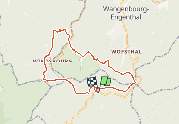
Ruta Senderismo de 16,6 km a descubrir en Gran Este, Bajo-Rin, Oberhaslach. Esta ruta ha sido propuesta por vaillantjm.
Descripción
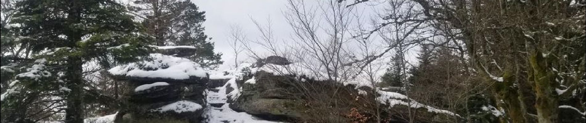
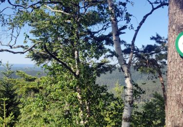
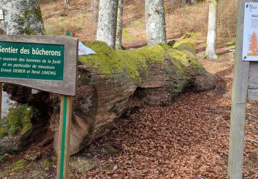
Variété de sentiers et chemins pour découvrir la forêt vosgienne dans toute sa profondeur. Une descente escarpée et rocailleuse peu arès le Scnneeberg.
Localización
País:
France
Región :
Gran Este
Departamento/provincia :
Bajo-Rin
Municipio :
Oberhaslach
Localidad:
Unknown
Salida:(Dec)
Salida:(UTM)
373852 ; 5382874 (32U) N.
Comentarios
Excursiones cerca
![Excursión Paseo ecuestre Oberhaslach - Neufeld Boucle Elmersforst - Photo](https://media.geolcdn.com/t/375/260/ext.jpg?maxdim=2&url=https%3A%2F%2Fstatic1.geolcdn.com%2Fsiteimages%2Fupload%2Ffiles%2F1524743154cheval.jpg)
![Paseo ecuestre Paseo ecuestre](https://static1.geolcdn.com/sitytour/trail-icons/301.png)
Neufeld Boucle Elmersforst
Paseo ecuestre
Difícil
(1)
Oberhaslach,
Gran Este,
Bajo-Rin,
France
![](/images/other/stat-length.png)
31 km | 42 km-effort
5h 9min
![](https://static1.geolcdn.com/siteimages/upload/files/16400158638029165_repeat_loop_refresh_sync_direction_icon.png)
Sí
![Excursión Senderismo Lutzelhouse - 2013-05-10 Marche Rocher de Mutzig par Nideck - Photo](https://media.geolcdn.com/t/375/260/ext.jpg?maxdim=2&url=https%3A%2F%2Fstatic1.geolcdn.com%2Fsiteimages%2Fupload%2Ffiles%2F1553511878bg_sport_marche.png)
![Senderismo Senderismo](https://static1.geolcdn.com/sitytour/trail-icons/101.png)
2013-05-10 Marche Rocher de Mutzig par Nideck
Senderismo
Medio
(1)
Lutzelhouse,
Gran Este,
Bajo-Rin,
France
![](/images/other/stat-length.png)
14,9 km | 24 km-effort
4h 10min
![](https://static1.geolcdn.com/siteimages/upload/files/16400158638029165_repeat_loop_refresh_sync_direction_icon.png)
Sí
![Excursión Bici de montaña Oberhaslach - Rando des Feuilles Mortes - Photo](https://media.geolcdn.com/t/375/260/ext.jpg?maxdim=2&url=https%3A%2F%2Fservices.sitytrail.com%2FGeolivesWS%2FDownloadMedia.ashx%3FTrailID%3D101060%26Media%3D551_1.jpg)
![Bici de montaña Bici de montaña](https://static1.geolcdn.com/sitytour/trail-icons/202.png)
Rando des Feuilles Mortes
Bici de montaña
Medio
(2)
Oberhaslach,
Gran Este,
Bajo-Rin,
France
![](/images/other/stat-length.png)
29 km | 41 km-effort
2h 0min
![](https://static1.geolcdn.com/siteimages/upload/files/16400158638029165_repeat_loop_refresh_sync_direction_icon.png)
Sí
![Excursión Paseo ecuestre Niederhaslach - Toutes fugues - Photo](https://media.geolcdn.com/t/375/260/ext.jpg?maxdim=2&url=https%3A%2F%2Fstatic1.geolcdn.com%2Fsiteimages%2Fupload%2Ffiles%2F1524743154cheval.jpg)
![Paseo ecuestre Paseo ecuestre](https://static1.geolcdn.com/sitytour/trail-icons/301.png)
Toutes fugues
Paseo ecuestre
Fácil
(1)
Niederhaslach,
Gran Este,
Bajo-Rin,
France
![](/images/other/stat-length.png)
29 km | 39 km-effort
Desconocido
![](https://static1.geolcdn.com/siteimages/upload/files/16400158638029165_repeat_loop_refresh_sync_direction_icon.png)
Sí
![Excursión Paseo ecuestre Still - 2022-07-10 Picnic CVA Umwurf depuis Oberhaslach - Photo](https://media.geolcdn.com/t/375/260/345719c4-c8c7-4272-8b46-e89c45a30cba.jpg&format=jpg&maxdim=2)
![Paseo ecuestre Paseo ecuestre](https://static1.geolcdn.com/sitytour/trail-icons/301.png)
2022-07-10 Picnic CVA Umwurf depuis Oberhaslach
Paseo ecuestre
Difícil
Still,
Gran Este,
Bajo-Rin,
France
![](/images/other/stat-length.png)
28 km | 40 km-effort
5h 53min
![](https://static1.geolcdn.com/siteimages/upload/files/16400158638029165_repeat_loop_refresh_sync_direction_icon.png)
Sí
![Excursión Senderismo Dabo - 2020-06-01 Marche Hengst - Photo](https://media.geolcdn.com/t/375/260/188abe8d-f41e-44e5-a426-fbd2513d6d58.jpg&format=jpg&maxdim=2)
![Senderismo Senderismo](https://static1.geolcdn.com/sitytour/trail-icons/101.png)
2020-06-01 Marche Hengst
Senderismo
Muy fácil
Dabo,
Gran Este,
Mosela,
France
![](/images/other/stat-length.png)
13,8 km | 18,7 km-effort
4h 18min
![](https://static1.geolcdn.com/siteimages/upload/files/16400158638029165_repeat_loop_refresh_sync_direction_icon.png)
Sí
![Excursión Senderismo Wangenbourg-Engenthal - 2019-11-16 Marche Wangenbourg Castelberg - Photo](https://media.geolcdn.com/t/375/260/5fe565fb-6e88-4bed-a889-a75a33bb061a.jpg&format=jpg&maxdim=2)
![Senderismo Senderismo](https://static1.geolcdn.com/sitytour/trail-icons/101.png)
2019-11-16 Marche Wangenbourg Castelberg
Senderismo
Muy fácil
Wangenbourg-Engenthal,
Gran Este,
Bajo-Rin,
France
![](/images/other/stat-length.png)
19,8 km | 31 km-effort
4h 51min
![](https://static1.geolcdn.com/siteimages/upload/files/16400158638029165_repeat_loop_refresh_sync_direction_icon.png)
Sí
![Excursión Senderismo Wangenbourg-Engenthal - 2017-02-24 Marche Schneeberg - Photo](https://media.geolcdn.com/t/375/260/ext.jpg?maxdim=2&url=https%3A%2F%2Fstatic1.geolcdn.com%2Fsiteimages%2Fupload%2Ffiles%2F1553511878bg_sport_marche.png)
![Senderismo Senderismo](https://static1.geolcdn.com/sitytour/trail-icons/101.png)
2017-02-24 Marche Schneeberg
Senderismo
Muy fácil
(1)
Wangenbourg-Engenthal,
Gran Este,
Bajo-Rin,
France
![](/images/other/stat-length.png)
12,8 km | 19,9 km-effort
Desconocido
![](https://static1.geolcdn.com/siteimages/upload/files/16400158638029165_repeat_loop_refresh_sync_direction_icon.png)
Sí
![Excursión Senderismo Oberhaslach - roche pfaffenlapp. oberhaslach - Photo](https://media.geolcdn.com/t/375/260/0d04f4b1-4b41-46da-b2c9-b0e99bb514b5.jpg&format=jpg&maxdim=2)
![Senderismo Senderismo](https://static1.geolcdn.com/sitytour/trail-icons/101.png)
roche pfaffenlapp. oberhaslach
Senderismo
Medio
Oberhaslach,
Gran Este,
Bajo-Rin,
France
![](/images/other/stat-length.png)
10,4 km | 17,3 km-effort
5h 5min
![](https://static1.geolcdn.com/siteimages/upload/files/16400158638029165_repeat_loop_refresh_sync_direction_icon.png)
Sí