![](/images/other/stat-length.png)
![Excursión Senderismo Aniane - Herault - Aniane Le tunnel Capion 15km 229m - Photo](https://media.geolcdn.com/t/1900/400/ext.pjpeg?maxdim=2&url=https%3A%2F%2Fstatic1.geolcdn.com%2Fsiteimages%2Fupload%2Ffiles%2F1553511878bg_sport_marche.png)
Herault - Aniane Le tunnel Capion 15km 229m
RandoVal
Usuario
![Longitud](/images/other/stat-length.png)
Longitud
15,1 km
![Altitud máxima](https://static1.geolcdn.com/siteimages/upload/files/1508320355ic_sort_altitude_max_24dp.png)
Altitud máxima
241 m
![Desnivel positivo](https://static1.geolcdn.com/siteimages/upload/files/1508320355ic_sort_den_pos_24dp.png)
Desnivel positivo
300 m
![Km-Effort](/images/other/stat-length.png)
Km-Effort
19,1 km
![Altitud mínima](https://static1.geolcdn.com/siteimages/upload/files/1508320355ic_sort_altitude_min_24dp.png)
Altitud mínima
79 m
![Desnivel negativo](https://static1.geolcdn.com/siteimages/upload/files/1508320355ic_sort_den_neg_24dp.png)
Desnivel negativo
302 m
![Boucle](https://static1.geolcdn.com/siteimages/upload/files/16400158638029165_repeat_loop_refresh_sync_direction_icon.png)
Boucle
Sí
Fecha de creación :
2020-03-03 12:46:04.751
Última modificación :
2020-03-03 12:48:23.411
![Senderismo](https://static1.geolcdn.com/sitytour/trail-icons/101.png)
--
Dificultad : Fácil
![Escanee este código QR para abrir la excursión en la aplicación SityTrail](https://capi.geolives.com/qq0zvz2zws4bq2lad0pu/sitytour/trails/2352559/qr.png?size=200)
Aplicación GPS de excursión GRATIS
A propósito
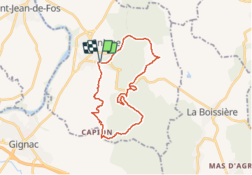
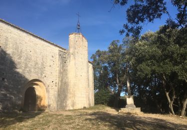
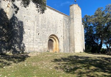
Ruta Senderismo de 15,1 km a descubrir en Occitania, Hérault, Aniane. Esta ruta ha sido propuesta por RandoVal.
Descripción
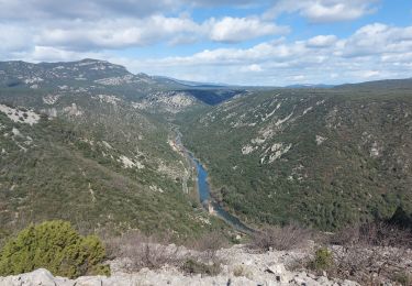
Petite rando entre vigne et collines dans l'Hérault, Départ et parking le long de la D27E2. Passage dans le tunnel de l'ancien chemin de fer prevoir une lampe. Sens horaire.
Localización
País:
France
Región :
Occitania
Departamento/provincia :
Hérault
Municipio :
Aniane
Localidad:
Unknown
Salida:(Dec)
Salida:(UTM)
547484 ; 4836643 (31T) N.
Comentarios
Excursiones cerca
![Excursión Senderismo Aniane - Aniane ruisseau des Corbières - Photo](https://media.geolcdn.com/t/375/260/ext.jpg?maxdim=2&url=https%3A%2F%2Fservices.sitytrail.com%2FGeolivesWS%2FDownloadMedia.ashx%3FTrailID%3D371677%26Media%3D20141221154017.jpg)
![Senderismo Senderismo](https://static1.geolcdn.com/sitytour/trail-icons/101.png)
Aniane ruisseau des Corbières
Senderismo
Fácil
(3)
Aniane,
Occitania,
Hérault,
France
![](/images/other/stat-length.png)
9,5 km | 12 km-effort
2h 34min
![](https://static1.geolcdn.com/siteimages/upload/files/16400158638029165_repeat_loop_refresh_sync_direction_icon.png)
Sí
![Excursión Senderismo Saint-Jean-de-Fos - St Jean de fos Les Plos - Photo](https://media.geolcdn.com/t/375/260/ext.jpg?maxdim=2&url=https%3A%2F%2Fservices.sitytrail.com%2FGeolivesWS%2FDownloadMedia.ashx%3FTrailID%3D358380%26Media%3D20141024141711.jpg)
![Senderismo Senderismo](https://static1.geolcdn.com/sitytour/trail-icons/101.png)
St Jean de fos Les Plos
Senderismo
Fácil
(3)
Saint-Jean-de-Fos,
Occitania,
Hérault,
France
![](/images/other/stat-length.png)
11 km | 15,2 km-effort
3h 5min
![](https://static1.geolcdn.com/siteimages/upload/files/16400158638029165_repeat_loop_refresh_sync_direction_icon.png)
Sí
![Excursión Senderismo Saint-Jean-de-Fos - St Jean de Fos et le Max Nègre - Photo](https://media.geolcdn.com/t/375/260/ext.jpg?maxdim=2&url=https%3A%2F%2Fservices.sitytrail.com%2FGeolivesWS%2FDownloadMedia.ashx%3FTrailID%3D230380%26Media%3Dfix__20131101122921.jpg)
![Senderismo Senderismo](https://static1.geolcdn.com/sitytour/trail-icons/101.png)
St Jean de Fos et le Max Nègre
Senderismo
Medio
Saint-Jean-de-Fos,
Occitania,
Hérault,
France
![](/images/other/stat-length.png)
19,1 km | 27 km-effort
5h 42min
![](https://static1.geolcdn.com/siteimages/upload/files/16400158638029165_repeat_loop_refresh_sync_direction_icon.png)
Sí
![Excursión Senderismo Puéchabon - Causse Puechabon - Photo](https://media.geolcdn.com/t/375/260/ext.jpg?maxdim=2&url=https%3A%2F%2Fstatic1.geolcdn.com%2Fsiteimages%2Fupload%2Ffiles%2F1553511878bg_sport_marche.png)
![Senderismo Senderismo](https://static1.geolcdn.com/sitytour/trail-icons/101.png)
Causse Puechabon
Senderismo
Muy fácil
(1)
Puéchabon,
Occitania,
Hérault,
France
![](/images/other/stat-length.png)
12,8 km | 15,9 km-effort
Desconocido
![](https://static1.geolcdn.com/siteimages/upload/files/16400158638029165_repeat_loop_refresh_sync_direction_icon.png)
Sí
![Excursión Senderismo La Boissière - 2024-11-05_19h16m17_autour-de-la-boissiere- - Photo](https://media.geolcdn.com/t/375/260/ext.jpg?maxdim=2&url=https%3A%2F%2Fstatic1.geolcdn.com%2Fsiteimages%2Fupload%2Ffiles%2F1553511878bg_sport_marche.png)
![Senderismo Senderismo](https://static1.geolcdn.com/sitytour/trail-icons/101.png)
2024-11-05_19h16m17_autour-de-la-boissiere-
Senderismo
Difícil
(1)
La Boissière,
Occitania,
Hérault,
France
![](/images/other/stat-length.png)
13,2 km | 17,1 km-effort
3h 52min
![](https://static1.geolcdn.com/siteimages/upload/files/16400158638029165_repeat_loop_refresh_sync_direction_icon.png)
Sí
![Excursión Senderismo Aniane - Plateau Montcamès - Photo](https://media.geolcdn.com/t/375/260/b02f8392-ab26-453d-ab12-fab47a60d22f.jpg&format=jpg&maxdim=2)
![Senderismo Senderismo](https://static1.geolcdn.com/sitytour/trail-icons/101.png)
Plateau Montcamès
Senderismo
Muy difícil
Aniane,
Occitania,
Hérault,
France
![](/images/other/stat-length.png)
17,7 km | 23 km-effort
6h 21min
![](https://static1.geolcdn.com/siteimages/upload/files/16400158638029165_repeat_loop_refresh_sync_direction_icon.png)
Sí
![Excursión Senderismo Saint-Guilhem-le-Désert - de Saint guilhem le désert au plot - Photo](https://media.geolcdn.com/t/375/260/85ed631a-0476-417c-a9f2-cea7a50cb9d8.jpg&format=jpg&maxdim=2)
![Senderismo Senderismo](https://static1.geolcdn.com/sitytour/trail-icons/101.png)
de Saint guilhem le désert au plot
Senderismo
Medio
Saint-Guilhem-le-Désert,
Occitania,
Hérault,
France
![](/images/other/stat-length.png)
16,8 km | 26 km-effort
6h 5min
![](https://static1.geolcdn.com/siteimages/upload/files/16400158638029165_repeat_loop_refresh_sync_direction_icon.png)
Sí
![Excursión Senderismo Puéchabon - Chapelle Saint-Sylvestre - Pioch de Ła Bastide - Photo](https://media.geolcdn.com/t/375/260/4441e2d5-932c-421a-a6dd-deaeea6979dd.jpg&format=jpg&maxdim=2)
![Senderismo Senderismo](https://static1.geolcdn.com/sitytour/trail-icons/101.png)
Chapelle Saint-Sylvestre - Pioch de Ła Bastide
Senderismo
Difícil
Puéchabon,
Occitania,
Hérault,
France
![](/images/other/stat-length.png)
15,2 km | 19,3 km-effort
5h 27min
![](https://static1.geolcdn.com/siteimages/upload/files/16400158638029165_repeat_loop_refresh_sync_direction_icon.png)
Sí
![Excursión Senderismo Puéchabon - Puechabon les crêtes de l’Herault - Photo](https://media.geolcdn.com/t/375/260/c7bd78fa-f414-42bd-9938-fea417bb3fa7.jpg&format=jpg&maxdim=2)
![Senderismo Senderismo](https://static1.geolcdn.com/sitytour/trail-icons/101.png)
Puechabon les crêtes de l’Herault
Senderismo
Muy difícil
Puéchabon,
Occitania,
Hérault,
France
![](/images/other/stat-length.png)
19 km | 25 km-effort
6h 9min
![](https://static1.geolcdn.com/siteimages/upload/files/16400158638029165_repeat_loop_refresh_sync_direction_icon.png)
Sí