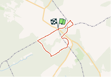
![](/images/other/stat-length.png)
![Excursión A pie Jalhay - Balade dans les Hautes Fagnes - Photo](https://media.geolcdn.com/t/1900/400/4512f107-713f-4e0e-b014-1887c6db2ad5.jpg&format=pjpeg&maxdim=2)
Balade dans les Hautes Fagnes
Desrumaux
Usuario GUIDE
![Longitud](/images/other/stat-length.png)
![Altitud máxima](https://static1.geolcdn.com/siteimages/upload/files/1508320355ic_sort_altitude_max_24dp.png)
![Desnivel positivo](https://static1.geolcdn.com/siteimages/upload/files/1508320355ic_sort_den_pos_24dp.png)
![Km-Effort](/images/other/stat-length.png)
![Altitud mínima](https://static1.geolcdn.com/siteimages/upload/files/1508320355ic_sort_altitude_min_24dp.png)
![Desnivel negativo](https://static1.geolcdn.com/siteimages/upload/files/1508320355ic_sort_den_neg_24dp.png)
![Boucle](https://static1.geolcdn.com/siteimages/upload/files/16400158638029165_repeat_loop_refresh_sync_direction_icon.png)
![A pie](https://static1.geolcdn.com/sitytour/trail-icons/100.png)
--
Dificultad : Muy fácil
![Escanee este código QR para abrir la excursión en la aplicación SityTrail](https://capi.geolives.com/qq0zvz2zws4bq2lad0pu/sitytour/trails/2351243/qr.png?size=200)
Aplicación GPS de excursión GRATIS
A propósito
Ruta A pie de 9,8 km a descubrir en Valonia, Lieja, Jalhay. Esta ruta ha sido propuesta por Desrumaux.
Descripción
Jolie balade hivernale sur le plateau des Hautes Fagnes au départ de la Baraque Michel.
La promenade emprunte le sentier de la Vecquée en passant par la Croix des Fiancés, la borne frontière entre la Belgique et la Prusse ainsi que le sentier didactique de la Poleûr entre la Baraque Michel et le Mont Rigi, la boucle se referme par un petit passage dans la Grande Fagne, la fontaine de Perigny et la Croix du Prieur.
Localización
Comentarios
Excursiones cerca
![Excursión Senderismo Waimes - RB-Lg-32_Botrange_via-racc-2 - Photo](https://media.geolcdn.com/t/375/260/ext.jpg?maxdim=2&url=https%3A%2F%2Fservices.sitytrail.com%2FGeolivesWS%2FDownloadMedia.ashx%3FTrailID%3D402164%26Media%3D5ad16311-48f2-4779-8b73-f8bce456ef00.jpg)
![Senderismo Senderismo](https://static1.geolcdn.com/sitytour/trail-icons/101.png)
Senderismo
![](/images/other/stat-length.png)
![](https://static1.geolcdn.com/siteimages/upload/files/16400158638029165_repeat_loop_refresh_sync_direction_icon.png)
![Excursión Senderismo Waimes - RB-Lg-32_Botrange_via-racc-1 - Photo](https://media.geolcdn.com/t/375/260/ext.jpg?maxdim=2&url=https%3A%2F%2Fservices.sitytrail.com%2FGeolivesWS%2FDownloadMedia.ashx%3FTrailID%3D402158%26Media%3D5ad16311-48f2-4779-8b73-f8bce456ef00.jpg)
![Senderismo Senderismo](https://static1.geolcdn.com/sitytour/trail-icons/101.png)
Senderismo
![](/images/other/stat-length.png)
![](https://static1.geolcdn.com/siteimages/upload/files/16400158638029165_repeat_loop_refresh_sync_direction_icon.png)
![Excursión Senderismo Waimes - RB-Lg-32_Botrange - Photo](https://media.geolcdn.com/t/375/260/ext.jpg?maxdim=2&url=https%3A%2F%2Fservices.sitytrail.com%2FGeolivesWS%2FDownloadMedia.ashx%3FTrailID%3D402156%26Media%3Dfd59a9ea-7261-4ddd-8af9-0290eaea98e9.jpg)
![Senderismo Senderismo](https://static1.geolcdn.com/sitytour/trail-icons/101.png)
![Excursión Senderismo Waimes - Balade Peak Myrtille avec extension - restaurée - Photo](https://media.geolcdn.com/t/375/260/ext.jpg?maxdim=2&url=https%3A%2F%2Fstatic1.geolcdn.com%2Fsiteimages%2Fupload%2Ffiles%2F1553511878bg_sport_marche.png)
![Senderismo Senderismo](https://static1.geolcdn.com/sitytour/trail-icons/101.png)
Senderismo
![](/images/other/stat-length.png)
![](https://static1.geolcdn.com/siteimages/upload/files/16400158638029165_repeat_loop_refresh_sync_direction_icon.png)
![Excursión Senderismo Waimes - Balade Peak Myrtille - restaurée - Photo](https://media.geolcdn.com/t/375/260/ext.jpg?maxdim=2&url=https%3A%2F%2Fstatic1.geolcdn.com%2Fsiteimages%2Fupload%2Ffiles%2F1553511878bg_sport_marche.png)
![Senderismo Senderismo](https://static1.geolcdn.com/sitytour/trail-icons/101.png)
Senderismo
![](/images/other/stat-length.png)
![](https://static1.geolcdn.com/siteimages/upload/files/16400158638029165_repeat_loop_refresh_sync_direction_icon.png)
![Excursión Senderismo Waimes - Balade Peak Beer IPA (new) - Photo](https://media.geolcdn.com/t/375/260/69787633-7ca3-4264-9ec3-6547631cb468.png&format=jpg&maxdim=2)
![Senderismo Senderismo](https://static1.geolcdn.com/sitytour/trail-icons/101.png)
Senderismo
![](/images/other/stat-length.png)
![](https://static1.geolcdn.com/siteimages/upload/files/16400158638029165_repeat_loop_refresh_sync_direction_icon.png)
![Excursión Senderismo Waimes - baraque Michel . botrange . baraque michel - Photo](https://media.geolcdn.com/t/375/260/c0a48186-0864-4f66-9ae4-72ca73dc2a0c.jpg&format=jpg&maxdim=2)
![Senderismo Senderismo](https://static1.geolcdn.com/sitytour/trail-icons/101.png)
Senderismo
![](/images/other/stat-length.png)
![](https://static1.geolcdn.com/siteimages/upload/files/16400158638029165_repeat_loop_refresh_sync_direction_icon.png)
![Excursión Senderismo Waimes - Prak beer brune - Photo](https://media.geolcdn.com/t/375/260/1004a3fe-d135-46da-92fc-7d19402e96c0.jpg&format=jpg&maxdim=2)
![Senderismo Senderismo](https://static1.geolcdn.com/sitytour/trail-icons/101.png)
Senderismo
![](/images/other/stat-length.png)
![](https://static1.geolcdn.com/siteimages/upload/files/16400158638029165_repeat_loop_refresh_sync_direction_icon.png)
![Excursión Senderismo Waimes - autour de botrange - Photo](https://media.geolcdn.com/t/375/260/95f2bbdc-2e88-456f-b9aa-be0405f02c88.jpg&format=jpg&maxdim=2)
![Senderismo Senderismo](https://static1.geolcdn.com/sitytour/trail-icons/101.png)
Senderismo
![](/images/other/stat-length.png)
![](https://static1.geolcdn.com/siteimages/upload/files/16400158638029165_repeat_loop_refresh_sync_direction_icon.png)