![](/images/other/stat-length.png)
![Excursión A pie Ornon - Refuge du Taillefer - Lac Fourchu - Photo](https://media.geolcdn.com/t/1900/400/ext.pjpeg?maxdim=2&url=https%3A%2F%2Fstatic1.geolcdn.com%2Fsiteimages%2Fupload%2Ffiles%2F1545311037marcheuse_200dpi.jpg)
Refuge du Taillefer - Lac Fourchu
Pierobert
Usuario
![Longitud](/images/other/stat-length.png)
![Altitud máxima](https://static1.geolcdn.com/siteimages/upload/files/1508320355ic_sort_altitude_max_24dp.png)
![Desnivel positivo](https://static1.geolcdn.com/siteimages/upload/files/1508320355ic_sort_den_pos_24dp.png)
![Km-Effort](/images/other/stat-length.png)
![Altitud mínima](https://static1.geolcdn.com/siteimages/upload/files/1508320355ic_sort_altitude_min_24dp.png)
![Desnivel negativo](https://static1.geolcdn.com/siteimages/upload/files/1508320355ic_sort_den_neg_24dp.png)
![Boucle](https://static1.geolcdn.com/siteimages/upload/files/16400158638029165_repeat_loop_refresh_sync_direction_icon.png)
![A pie](https://static1.geolcdn.com/sitytour/trail-icons/100.png)
--
Dificultad : Muy difícil
![Escanee este código QR para abrir la excursión en la aplicación SityTrail](https://capi.geolives.com/qq0zvz2zws4bq2lad0pu/sitytour/trails/2350563/qr.png?size=200)
Aplicación GPS de excursión GRATIS
A propósito
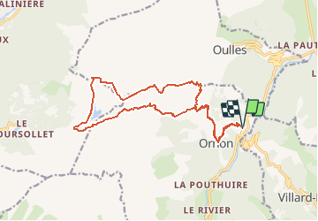
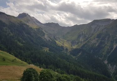
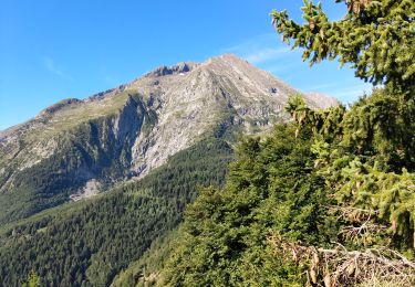
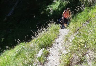
Ruta A pie de 17,8 km a descubrir en Auvergne-Rhône-Alpes, Isère, Ornon. Esta ruta ha sido propuesta por Pierobert.
Descripción
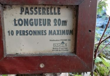
Au départ de la Palud (952 m), gagner Ornon, puis le refuge du Taillefer en suivant le GR 50. Poursuivre le GR 50 jusqu'au Pas de l'Envious, remonter NO jusqu'à La Valette d'où on amorcera le retour en contournant le lac Canard, puis le lac Fourchu. Peu après le sud de ce lac, on obliquera ENE en direction de la bergerie de la Jasse. De là, on continuera pour rejoindre le GR 50 et utiliser le chemin de l'aller pour rejoindre la Palud via Ornon.
Localización
Comentarios
Excursiones cerca
![Excursión Senderismo Le Bourg-d'Oisans - 38 BG d Oisans cascade pisse - Photo](https://media.geolcdn.com/t/375/260/2e81579a-11c0-4302-b399-8bc55cc0dd5f.jpg&format=jpg&maxdim=2)
![Senderismo Senderismo](https://static1.geolcdn.com/sitytour/trail-icons/101.png)
Senderismo
![](/images/other/stat-length.png)
![](https://static1.geolcdn.com/siteimages/upload/files/16400158638029165_repeat_loop_refresh_sync_direction_icon.png)
![Excursión Esquí de fondo Ornon - Le Taillefer - Photo](https://media.geolcdn.com/t/375/260/c574ba01-aae9-4665-88a5-f41d16e34e2a.jpg&format=jpg&maxdim=2)
![Esquí de fondo Esquí de fondo](https://static1.geolcdn.com/sitytour/trail-icons/503.png)
Esquí de fondo
![](/images/other/stat-length.png)
![](https://static1.geolcdn.com/siteimages/upload/files/16400158638029165_repeat_loop_refresh_sync_direction_icon.png)
![Excursión Esquí de fondo Oulles - Le Grand Galbert - Photo](https://media.geolcdn.com/t/375/260/deb5abfe-9d12-4610-a034-8cf37e109247.jpg&format=jpg&maxdim=2)
![Esquí de fondo Esquí de fondo](https://static1.geolcdn.com/sitytour/trail-icons/503.png)
Esquí de fondo
![](/images/other/stat-length.png)
![](https://static1.geolcdn.com/siteimages/upload/files/16400158638029165_repeat_loop_refresh_sync_direction_icon.png)
![Excursión Senderismo Le Bourg-d'Oisans - Lac de Buclet et cascade de la Pisse - Photo](https://media.geolcdn.com/t/375/260/7920e5ce-d45f-4ce3-8489-7c3261ef3795.jpg&format=jpg&maxdim=2)
![Senderismo Senderismo](https://static1.geolcdn.com/sitytour/trail-icons/101.png)
Senderismo
![](/images/other/stat-length.png)
![](https://static1.geolcdn.com/siteimages/upload/files/16400158638029165_repeat_loop_refresh_sync_direction_icon.png)
![Excursión Senderismo Ornon - Plateau des lacs - Photo](https://media.geolcdn.com/t/375/260/95c91083-32aa-44d3-b116-e3d30f3c6317.jpg&format=jpg&maxdim=2)
![Senderismo Senderismo](https://static1.geolcdn.com/sitytour/trail-icons/101.png)
Senderismo
![](/images/other/stat-length.png)
![](https://static1.geolcdn.com/siteimages/upload/files/16400158638029165_repeat_loop_refresh_sync_direction_icon.png)
![Excursión Senderismo Villard-Reymond - La Croix du Carrelet et la crête de Croix de La Garde - Photo](https://media.geolcdn.com/t/375/260/719f71c8-5764-4d7d-9547-f0e72ea0e1f5.jpg&format=jpg&maxdim=2)
![Senderismo Senderismo](https://static1.geolcdn.com/sitytour/trail-icons/101.png)
Senderismo
![](/images/other/stat-length.png)
![](https://static1.geolcdn.com/siteimages/upload/files/16400158638029165_repeat_loop_refresh_sync_direction_icon.png)
![Excursión Senderismo Le Bourg-d'Oisans - Bourg d'Oisans les cascades - Photo](https://media.geolcdn.com/t/375/260/f162be93-5b19-484b-970f-69f2c59af7f2.jpg&format=jpg&maxdim=2)
![Senderismo Senderismo](https://static1.geolcdn.com/sitytour/trail-icons/101.png)
Senderismo
![](/images/other/stat-length.png)
![](https://static1.geolcdn.com/siteimages/upload/files/16400158638029165_repeat_loop_refresh_sync_direction_icon.png)
![Excursión Senderismo Ornon - Plateau des lacs, lac Fourchu. par bergerie - Photo](https://media.geolcdn.com/t/375/260/96726bb9-ed4e-493b-a6c3-1add5f355935.jpg&format=jpg&maxdim=2)
![Senderismo Senderismo](https://static1.geolcdn.com/sitytour/trail-icons/101.png)
Senderismo
![](/images/other/stat-length.png)
![](https://static1.geolcdn.com/siteimages/upload/files/16400158638029165_repeat_loop_refresh_sync_direction_icon.png)
![Excursión Senderismo Villard-Notre-Dame - villard Redmond - Photo](https://media.geolcdn.com/t/375/260/06639bd3-b0d9-4d0a-b2aa-40bb1a3232fe.jpg&format=jpg&maxdim=2)
![Senderismo Senderismo](https://static1.geolcdn.com/sitytour/trail-icons/101.png)
Senderismo
![](/images/other/stat-length.png)
![](https://static1.geolcdn.com/siteimages/upload/files/16400158638029165_repeat_loop_refresh_sync_direction_icon.png)