![](/images/other/stat-length.png)
![Excursión Senderismo Bournezeau - Sentier des Châteaux - Bournezeau - Photo](https://media.geolcdn.com/t/1900/400/ext.pjpeg?maxdim=2&url=https%3A%2F%2Fstatic1.geolcdn.com%2Fsiteimages%2Fupload%2Ffiles%2F1553511878bg_sport_marche.png)
Sentier des Châteaux - Bournezeau
neoroll44
Usuario
![Longitud](/images/other/stat-length.png)
Longitud
11 km
![Altitud máxima](https://static1.geolcdn.com/siteimages/upload/files/1508320355ic_sort_altitude_max_24dp.png)
Altitud máxima
85 m
![Desnivel positivo](https://static1.geolcdn.com/siteimages/upload/files/1508320355ic_sort_den_pos_24dp.png)
Desnivel positivo
128 m
![Km-Effort](/images/other/stat-length.png)
Km-Effort
12,7 km
![Altitud mínima](https://static1.geolcdn.com/siteimages/upload/files/1508320355ic_sort_altitude_min_24dp.png)
Altitud mínima
40 m
![Desnivel negativo](https://static1.geolcdn.com/siteimages/upload/files/1508320355ic_sort_den_neg_24dp.png)
Desnivel negativo
128 m
![Boucle](https://static1.geolcdn.com/siteimages/upload/files/16400158638029165_repeat_loop_refresh_sync_direction_icon.png)
Boucle
Sí
Fecha de creación :
2020-02-29 18:34:49.384
Última modificación :
2020-02-29 18:35:39.16
![Senderismo](https://static1.geolcdn.com/sitytour/trail-icons/101.png)
2h47
Dificultad : Medio
![Escanee este código QR para abrir la excursión en la aplicación SityTrail](https://capi.geolives.com/qq0zvz2zws4bq2lad0pu/sitytour/trails/2350030/qr.png?size=200)
Aplicación GPS de excursión GRATIS
A propósito
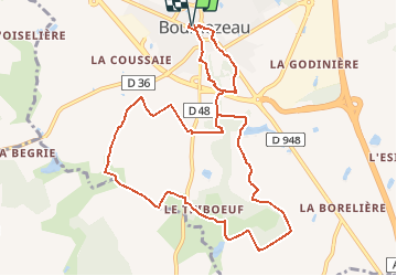
Ruta Senderismo de 11 km a descubrir en Países del Loira, Vandea, Bournezeau. Esta ruta ha sido propuesta por neoroll44.
Descripción
Départ : Place des Papillons Distance : 11 km Signalétique : Sentier n°1 Blanc A découvrir : - Le logis de Beauregard - Château du Pavillon - Château de Thiboeuf - Domaine de la Corbedomère - Stèle
Puntos de interés
Localización
País:
France
Región :
Países del Loira
Departamento/provincia :
Vandea
Municipio :
Bournezeau
Localidad:
Unknown
Salida:(Dec)
Salida:(UTM)
639883 ; 5166358 (30T) N.
Comentarios
Excursiones cerca
![Excursión Senderismo Saint-Hilaire-le-Vouhis - lac de la Vouraie - Photo](https://media.geolcdn.com/t/375/260/ext.jpg?maxdim=2&url=https%3A%2F%2Fstatic1.geolcdn.com%2Fsiteimages%2Fupload%2Ffiles%2F1553511878bg_sport_marche.png)
![Senderismo Senderismo](https://static1.geolcdn.com/sitytour/trail-icons/101.png)
lac de la Vouraie
Senderismo
Medio
(1)
Saint-Hilaire-le-Vouhis,
Países del Loira,
Vandea,
France
![](/images/other/stat-length.png)
15,9 km | 18,7 km-effort
2h 19min
![](https://static1.geolcdn.com/siteimages/upload/files/16400158638029165_repeat_loop_refresh_sync_direction_icon.png)
Sí
![Excursión Senderismo Bournezeau - Tour du Lac de Vouraie - Photo](https://media.geolcdn.com/t/375/260/ext.jpg?maxdim=2&url=https%3A%2F%2Fstatic1.geolcdn.com%2Fsiteimages%2Fupload%2Ffiles%2F1553511878bg_sport_marche.png)
![Senderismo Senderismo](https://static1.geolcdn.com/sitytour/trail-icons/101.png)
Tour du Lac de Vouraie
Senderismo
Difícil
Bournezeau,
Países del Loira,
Vandea,
France
![](/images/other/stat-length.png)
14,1 km | 16,3 km-effort
3h 34min
![](https://static1.geolcdn.com/siteimages/upload/files/16400158638029165_repeat_loop_refresh_sync_direction_icon.png)
Sí
![Excursión Senderismo Fougeré - Pays Yon & Vie. 18 sentier du châtaignier - Photo](https://media.geolcdn.com/t/375/260/ext.jpg?maxdim=2&url=https%3A%2F%2Fstatic1.geolcdn.com%2Fsiteimages%2Fupload%2Ffiles%2F1553511878bg_sport_marche.png)
![Senderismo Senderismo](https://static1.geolcdn.com/sitytour/trail-icons/101.png)
Pays Yon & Vie. 18 sentier du châtaignier
Senderismo
Fácil
Fougeré,
Países del Loira,
Vandea,
France
![](/images/other/stat-length.png)
15,9 km | 17,5 km-effort
3h 50min
![](https://static1.geolcdn.com/siteimages/upload/files/16400158638029165_repeat_loop_refresh_sync_direction_icon.png)
Sí
![Excursión Senderismo Bournezeau - GR364-Jour n° 6 - Photo](https://media.geolcdn.com/t/375/260/ext.jpg?maxdim=2&url=https%3A%2F%2Fstatic1.geolcdn.com%2Fsiteimages%2Fupload%2Ffiles%2F1553511878bg_sport_marche.png)
![Senderismo Senderismo](https://static1.geolcdn.com/sitytour/trail-icons/101.png)
GR364-Jour n° 6
Senderismo
Muy difícil
Bournezeau,
Países del Loira,
Vandea,
France
![](/images/other/stat-length.png)
24 km | 27 km-effort
6h 12min
![](https://static1.geolcdn.com/siteimages/upload/files/16400158638029165_repeat_loop_refresh_sync_direction_icon.png)
No
![Excursión Senderismo Fougeré - bois de la chaîne - Photo](https://media.geolcdn.com/t/375/260/ext.jpg?maxdim=2&url=https%3A%2F%2Fstatic1.geolcdn.com%2Fsiteimages%2Fupload%2Ffiles%2F1553511878bg_sport_marche.png)
![Senderismo Senderismo](https://static1.geolcdn.com/sitytour/trail-icons/101.png)
bois de la chaîne
Senderismo
Fácil
Fougeré,
Países del Loira,
Vandea,
France
![](/images/other/stat-length.png)
5 km | 5,5 km-effort
2h 44min
![](https://static1.geolcdn.com/siteimages/upload/files/16400158638029165_repeat_loop_refresh_sync_direction_icon.png)
Sí
![Excursión Senderismo Bournezeau - N°69 Vendée rando. De châteaux en ruisseaux Bournezeau - Photo](https://media.geolcdn.com/t/375/260/ext.jpg?maxdim=2&url=https%3A%2F%2Fstatic1.geolcdn.com%2Fsiteimages%2Fupload%2Ffiles%2F1553511878bg_sport_marche.png)
![Senderismo Senderismo](https://static1.geolcdn.com/sitytour/trail-icons/101.png)
N°69 Vendée rando. De châteaux en ruisseaux Bournezeau
Senderismo
Muy fácil
Bournezeau,
Países del Loira,
Vandea,
France
![](/images/other/stat-length.png)
15,3 km | 17,5 km-effort
3h 33min
![](https://static1.geolcdn.com/siteimages/upload/files/16400158638029165_repeat_loop_refresh_sync_direction_icon.png)
Sí
![Excursión Senderismo Bournezeau - Bournezeau La Vouraie - Photo](https://media.geolcdn.com/t/375/260/ext.jpg?maxdim=2&url=https%3A%2F%2Fstatic1.geolcdn.com%2Fsiteimages%2Fupload%2Ffiles%2F1553511878bg_sport_marche.png)
![Senderismo Senderismo](https://static1.geolcdn.com/sitytour/trail-icons/101.png)
Bournezeau La Vouraie
Senderismo
Medio
Bournezeau,
Países del Loira,
Vandea,
France
![](/images/other/stat-length.png)
14 km | 16,3 km-effort
3h 34min
![](https://static1.geolcdn.com/siteimages/upload/files/16400158638029165_repeat_loop_refresh_sync_direction_icon.png)
Sí
![Excursión Senderismo Bournezeau - st Vincent - Photo](https://media.geolcdn.com/t/375/260/ext.jpg?maxdim=2&url=https%3A%2F%2Fstatic1.geolcdn.com%2Fsiteimages%2Fupload%2Ffiles%2F1553511878bg_sport_marche.png)
![Senderismo Senderismo](https://static1.geolcdn.com/sitytour/trail-icons/101.png)
st Vincent
Senderismo
Fácil
Bournezeau,
Países del Loira,
Vandea,
France
![](/images/other/stat-length.png)
2,6 km | 3,2 km-effort
47min
![](https://static1.geolcdn.com/siteimages/upload/files/16400158638029165_repeat_loop_refresh_sync_direction_icon.png)
Sí