![](/images/other/stat-length.png)
![Excursión Senderismo Roquebrune-sur-Argens - ROQUEBRUNE SUR ARGENS - A L'OUEST DE LA FLUTE - Photo](https://media.geolcdn.com/t/1900/400/4c72e204-0e18-457c-8cea-945f72cb28af.jpg&format=pjpeg&maxdim=2)
ROQUEBRUNE SUR ARGENS - A L'OUEST DE LA FLUTE
jean-marie.parachini
Usuario
![Longitud](/images/other/stat-length.png)
Longitud
12,1 km
![Altitud máxima](https://static1.geolcdn.com/siteimages/upload/files/1508320355ic_sort_altitude_max_24dp.png)
Altitud máxima
312 m
![Desnivel positivo](https://static1.geolcdn.com/siteimages/upload/files/1508320355ic_sort_den_pos_24dp.png)
Desnivel positivo
330 m
![Km-Effort](/images/other/stat-length.png)
Km-Effort
16,5 km
![Altitud mínima](https://static1.geolcdn.com/siteimages/upload/files/1508320355ic_sort_altitude_min_24dp.png)
Altitud mínima
14 m
![Desnivel negativo](https://static1.geolcdn.com/siteimages/upload/files/1508320355ic_sort_den_neg_24dp.png)
Desnivel negativo
329 m
![Boucle](https://static1.geolcdn.com/siteimages/upload/files/16400158638029165_repeat_loop_refresh_sync_direction_icon.png)
Boucle
Sí
Fecha de creación :
2020-02-20 08:32:50.274
Última modificación :
2020-02-20 17:36:54.624
![Senderismo](https://static1.geolcdn.com/sitytour/trail-icons/101.png)
5h17
Dificultad : Fácil
![Escanee este código QR para abrir la excursión en la aplicación SityTrail](https://capi.geolives.com/qq0zvz2zws4bq2lad0pu/sitytour/trails/2341038/qr.png?size=200)
Aplicación GPS de excursión GRATIS
A propósito
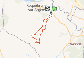
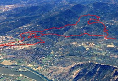
Ruta Senderismo de 12,1 km a descubrir en Provenza-Alpes-Costa Azul, Var, Roquebrune-sur-Argens. Esta ruta ha sido propuesta por jean-marie.parachini.
Descripción
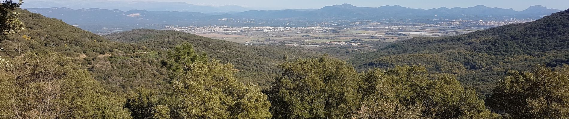
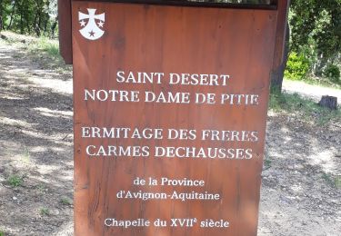
Forêt de mimosas et panorama sur Frejus, Saint-Raphael, les sommets de l'Esterel, rocher de Roquebrune.
Localización
País:
France
Región :
Provenza-Alpes-Costa Azul
Departamento/provincia :
Var
Municipio :
Roquebrune-sur-Argens
Localidad:
Unknown
Salida:(Dec)
Salida:(UTM)
310410 ; 4811934 (32T) N.
Comentarios
Excursiones cerca
![Excursión Senderismo Roquebrune-sur-Argens - SityTrail - Les 25 ponts-Roquebrune sur Argens-28-01-22 - Photo](https://media.geolcdn.com/t/375/260/605c9bb1-f90a-4cd2-a653-fe52e6d3d081.jpg&format=jpg&maxdim=2)
![Senderismo Senderismo](https://static1.geolcdn.com/sitytour/trail-icons/101.png)
SityTrail - Les 25 ponts-Roquebrune sur Argens-28-01-22
Senderismo
Medio
(1)
Roquebrune-sur-Argens,
Provenza-Alpes-Costa Azul,
Var,
France
![](/images/other/stat-length.png)
14,4 km | 20 km-effort
6h 0min
![](https://static1.geolcdn.com/siteimages/upload/files/16400158638029165_repeat_loop_refresh_sync_direction_icon.png)
Sí
![Excursión Senderismo Roquebrune-sur-Argens - Rocher de Roquebrune, les Trois Croix - Photo](https://media.geolcdn.com/t/375/260/ext.jpg?maxdim=2&url=https%3A%2F%2Fservices.sitytrail.com%2FGeolivesWS%2FDownloadMedia.ashx%3FTrailID%3D173163%26Media%3D14736_1.jpg)
![Senderismo Senderismo](https://static1.geolcdn.com/sitytour/trail-icons/101.png)
Rocher de Roquebrune, les Trois Croix
Senderismo
Difícil
(4)
Roquebrune-sur-Argens,
Provenza-Alpes-Costa Azul,
Var,
France
![](/images/other/stat-length.png)
7 km | 11,4 km-effort
4h 15min
![](https://static1.geolcdn.com/siteimages/upload/files/16400158638029165_repeat_loop_refresh_sync_direction_icon.png)
Sí
![Excursión Senderismo Roquebrune-sur-Argens - les merles 2 - Photo](https://media.geolcdn.com/t/375/260/ext.jpg?maxdim=2&url=https%3A%2F%2Fstatic1.geolcdn.com%2Fsiteimages%2Fupload%2Ffiles%2F1553511878bg_sport_marche.png)
![Senderismo Senderismo](https://static1.geolcdn.com/sitytour/trail-icons/101.png)
les merles 2
Senderismo
Medio
(1)
Roquebrune-sur-Argens,
Provenza-Alpes-Costa Azul,
Var,
France
![](/images/other/stat-length.png)
6,6 km | 7,9 km-effort
1h 47min
![](https://static1.geolcdn.com/siteimages/upload/files/16400158638029165_repeat_loop_refresh_sync_direction_icon.png)
Sí
![Excursión Senderismo Roquebrune-sur-Argens - 2023-10-25_17h14m36_Randonn_e-27 - Photo](https://media.geolcdn.com/t/375/260/ext.jpg?maxdim=2&url=https%3A%2F%2Fstatic1.geolcdn.com%2Fsiteimages%2Fupload%2Ffiles%2F1553511878bg_sport_marche.png)
![Senderismo Senderismo](https://static1.geolcdn.com/sitytour/trail-icons/101.png)
2023-10-25_17h14m36_Randonn_e-27
Senderismo
Difícil
(1)
Roquebrune-sur-Argens,
Provenza-Alpes-Costa Azul,
Var,
France
![](/images/other/stat-length.png)
9,2 km | 12,6 km-effort
2h 52min
![](https://static1.geolcdn.com/siteimages/upload/files/16400158638029165_repeat_loop_refresh_sync_direction_icon.png)
Sí
![Excursión Senderismo Roquebrune-sur-Argens - Autour de la Maurette (variante) - Photo](https://media.geolcdn.com/t/375/260/9e327cd4-b701-4d2e-839f-23509b76ff37.jpg&format=jpg&maxdim=2)
![Senderismo Senderismo](https://static1.geolcdn.com/sitytour/trail-icons/101.png)
Autour de la Maurette (variante)
Senderismo
Muy difícil
Roquebrune-sur-Argens,
Provenza-Alpes-Costa Azul,
Var,
France
![](/images/other/stat-length.png)
16,5 km | 23 km-effort
4h 10min
![](https://static1.geolcdn.com/siteimages/upload/files/16400158638029165_repeat_loop_refresh_sync_direction_icon.png)
Sí
![Excursión A pie Roquebrune-sur-Argens - Roquebrune sur argens-Les 25 Ponds-ND de la pitié- Lac des clos - Photo](https://media.geolcdn.com/t/375/260/ext.jpg?maxdim=2&url=https%3A%2F%2Fstatic1.geolcdn.com%2Fsiteimages%2Fupload%2Ffiles%2F1545311037marcheuse_200dpi.jpg)
![A pie A pie](https://static1.geolcdn.com/sitytour/trail-icons/100.png)
Roquebrune sur argens-Les 25 Ponds-ND de la pitié- Lac des clos
A pie
Fácil
(1)
Roquebrune-sur-Argens,
Provenza-Alpes-Costa Azul,
Var,
France
![](/images/other/stat-length.png)
11,9 km | 17 km-effort
3h 51min
![](https://static1.geolcdn.com/siteimages/upload/files/16400158638029165_repeat_loop_refresh_sync_direction_icon.png)
Sí
![Excursión Senderismo Roquebrune-sur-Argens - les hauts de Roquebrune sur Argens - Photo](https://media.geolcdn.com/t/375/260/fb3b5c94-db8e-400d-a9b2-b3a4bc6a654b.jpg&format=jpg&maxdim=2)
![Senderismo Senderismo](https://static1.geolcdn.com/sitytour/trail-icons/101.png)
les hauts de Roquebrune sur Argens
Senderismo
Fácil
(1)
Roquebrune-sur-Argens,
Provenza-Alpes-Costa Azul,
Var,
France
![](/images/other/stat-length.png)
6,2 km | 8,9 km-effort
2h 9min
![](https://static1.geolcdn.com/siteimages/upload/files/16400158638029165_repeat_loop_refresh_sync_direction_icon.png)
Sí
![Excursión Senderismo Roquebrune-sur-Argens - Le sentier découverte des 25 ponts - Photo](https://media.geolcdn.com/t/375/260/ext.jpg?maxdim=2&url=https%3A%2F%2Fstatic1.geolcdn.com%2Fsiteimages%2Fupload%2Ffiles%2F1553511878bg_sport_marche.png)
![Senderismo Senderismo](https://static1.geolcdn.com/sitytour/trail-icons/101.png)
Le sentier découverte des 25 ponts
Senderismo
Muy fácil
(1)
Roquebrune-sur-Argens,
Provenza-Alpes-Costa Azul,
Var,
France
![](/images/other/stat-length.png)
4,5 km | 6 km-effort
Desconocido
![](https://static1.geolcdn.com/siteimages/upload/files/16400158638029165_repeat_loop_refresh_sync_direction_icon.png)
Sí
![Excursión Bici de montaña Roquebrune-sur-Argens - 2013 05 01 - Photo](https://media.geolcdn.com/t/375/260/ext.jpg?maxdim=2&url=https%3A%2F%2Fstatic1.geolcdn.com%2Fsiteimages%2Fupload%2Ffiles%2F1524743154velo.jpg)
![Bici de montaña Bici de montaña](https://static1.geolcdn.com/sitytour/trail-icons/202.png)
2013 05 01
Bici de montaña
Medio
(1)
Roquebrune-sur-Argens,
Provenza-Alpes-Costa Azul,
Var,
France
![](/images/other/stat-length.png)
23 km | 33 km-effort
4h 8min
![](https://static1.geolcdn.com/siteimages/upload/files/16400158638029165_repeat_loop_refresh_sync_direction_icon.png)
No