![](/images/other/stat-length.png)
![Excursión Senderismo Sentheim - Haut Soultzbach - Photo](https://media.geolcdn.com/t/1900/400/31950b9d-221b-4bb4-8acb-21f4d1616726.jpg&format=pjpeg&maxdim=2)
Haut Soultzbach
helmut68
Usuario
![Longitud](/images/other/stat-length.png)
![Altitud máxima](https://static1.geolcdn.com/siteimages/upload/files/1508320355ic_sort_altitude_max_24dp.png)
![Desnivel positivo](https://static1.geolcdn.com/siteimages/upload/files/1508320355ic_sort_den_pos_24dp.png)
![Km-Effort](/images/other/stat-length.png)
![Altitud mínima](https://static1.geolcdn.com/siteimages/upload/files/1508320355ic_sort_altitude_min_24dp.png)
![Desnivel negativo](https://static1.geolcdn.com/siteimages/upload/files/1508320355ic_sort_den_neg_24dp.png)
![Boucle](https://static1.geolcdn.com/siteimages/upload/files/16400158638029165_repeat_loop_refresh_sync_direction_icon.png)
![Senderismo](https://static1.geolcdn.com/sitytour/trail-icons/101.png)
4h10
Dificultad : Fácil
![Escanee este código QR para abrir la excursión en la aplicación SityTrail](https://capi.geolives.com/qq0zvz2zws4bq2lad0pu/sitytour/trails/2337219/qr.png?size=200)
Aplicación GPS de excursión GRATIS
A propósito
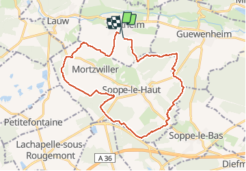
Ruta Senderismo de 17,7 km a descubrir en Gran Este, Alto Rin, Sentheim. Esta ruta ha sido propuesta por helmut68.
Descripción
Départ et arrivée place de jeux de Sentheim .Prener la route de Mortzwiller jusqu'en haut de la colline,puis emprunter le chemin à votre drote qui mène dans la forêt.
Suivre le balisage " disque rouge " , " disque jaune " , " Croix rouge " et enfin le " "triangle bleu " jusqu'à la chapelle " Notre Dame des Bouleaux" . De là suivre le balisage " croix jaune" jusqu'à Sentheim.
Très belle randonnée qui vous fait découvrir le Haut Soultzbach ( communes de Mortzwiller, Soppe le Haut ...) et ses beaux points de vue.
Alors à vos chaussures ...
Localización
Comentarios
Excursiones cerca
![Excursión Senderismo Masevaux-Niederbruck - Masevaux - Rossberg par le belvédère du Fuchsfelsen - Photo](https://media.geolcdn.com/t/375/260/d9cc765c-1250-4953-9d9f-fb8b88eb82a7.jpg&format=jpg&maxdim=2)
![Senderismo Senderismo](https://static1.geolcdn.com/sitytour/trail-icons/101.png)
Senderismo
![](/images/other/stat-length.png)
![](https://static1.geolcdn.com/siteimages/upload/files/16400158638029165_repeat_loop_refresh_sync_direction_icon.png)
![Excursión Senderismo Sentheim - Sentheim Rossberg - Photo](https://media.geolcdn.com/t/375/260/a036ff16-f534-44a4-ad7d-39598edf8c1e.jpg&format=jpg&maxdim=2)
![Senderismo Senderismo](https://static1.geolcdn.com/sitytour/trail-icons/101.png)
Senderismo
![](/images/other/stat-length.png)
![](https://static1.geolcdn.com/siteimages/upload/files/16400158638029165_repeat_loop_refresh_sync_direction_icon.png)
![Excursión Senderismo Lauw - 2022-07-14 Marche Lauw Refuge CAF Baerenkopf - Photo](https://media.geolcdn.com/t/375/260/e2209d17-65ac-46f6-a404-5274e10a843e.jpg&format=jpg&maxdim=2)
![Senderismo Senderismo](https://static1.geolcdn.com/sitytour/trail-icons/101.png)
Senderismo
![](/images/other/stat-length.png)
![](https://static1.geolcdn.com/siteimages/upload/files/16400158638029165_repeat_loop_refresh_sync_direction_icon.png)
![Excursión A pie Sentheim - Sentier géologique du Wolfloch - Photo](https://media.geolcdn.com/t/375/260/3b31644e-e98b-4e9b-958d-a3c4208c2bbd.jpeg&format=jpg&maxdim=2)
![A pie A pie](https://static1.geolcdn.com/sitytour/trail-icons/100.png)
A pie
![](/images/other/stat-length.png)
![](https://static1.geolcdn.com/siteimages/upload/files/16400158638029165_repeat_loop_refresh_sync_direction_icon.png)
![Excursión A pie Sentheim - Sentheim - Bergwald - Eichwald - Guevenheim - Sentheim - Photo](https://media.geolcdn.com/t/375/260/ext.jpg?maxdim=2&url=https%3A%2F%2Fstatic1.geolcdn.com%2Fsiteimages%2Fupload%2Ffiles%2F1545311037marcheuse_200dpi.jpg)
![A pie A pie](https://static1.geolcdn.com/sitytour/trail-icons/100.png)
A pie
![](/images/other/stat-length.png)
![](https://static1.geolcdn.com/siteimages/upload/files/16400158638029165_repeat_loop_refresh_sync_direction_icon.png)
![Excursión Senderismo Masevaux-Niederbruck - Reco avec ALAIN..Rando CLAS du 29/08/2024 - Photo](https://media.geolcdn.com/t/375/260/5dba7985-af1b-4076-a275-05f9cb5145f8.jpg&format=jpg&maxdim=2)
![Senderismo Senderismo](https://static1.geolcdn.com/sitytour/trail-icons/101.png)
Senderismo
![](/images/other/stat-length.png)
![](https://static1.geolcdn.com/siteimages/upload/files/16400158638029165_repeat_loop_refresh_sync_direction_icon.png)
![Excursión Senderismo Sentheim - Randonnée Pentecôte 2024 - Photo](https://media.geolcdn.com/t/375/260/5b01bebc-5c9b-4fee-93d4-97171ac59809.jpg&format=jpg&maxdim=2)
![Senderismo Senderismo](https://static1.geolcdn.com/sitytour/trail-icons/101.png)
Senderismo
![](/images/other/stat-length.png)
![](https://static1.geolcdn.com/siteimages/upload/files/16400158638029165_repeat_loop_refresh_sync_direction_icon.png)
![Excursión Senderismo Sentheim - Knapphutte Saegenkopf Hütte - Photo](https://media.geolcdn.com/t/375/260/40c0149e-a232-4115-bfb0-15079675190f.jpg&format=jpg&maxdim=2)
![Senderismo Senderismo](https://static1.geolcdn.com/sitytour/trail-icons/101.png)
Senderismo
![](/images/other/stat-length.png)
![](https://static1.geolcdn.com/siteimages/upload/files/16400158638029165_repeat_loop_refresh_sync_direction_icon.png)
![Excursión Senderismo Sentheim - Montori - Photo](https://media.geolcdn.com/t/375/260/60fb76bf-d069-4a22-ad34-ce9de6b50bcf.jpg&format=jpg&maxdim=2)
![Senderismo Senderismo](https://static1.geolcdn.com/sitytour/trail-icons/101.png)