![](/images/other/stat-length.png)
![Excursión A pie Roquebrune-sur-Argens - z les bois de Roquebrune 11-02-20 - Photo](https://media.geolcdn.com/t/1900/400/98ec0486-94bc-4c3b-b9ec-d4749c60eae3.jpg&format=pjpeg&maxdim=2)
z les bois de Roquebrune 11-02-20
cb8310
Usuario
![Longitud](/images/other/stat-length.png)
Longitud
6,7 km
![Altitud máxima](https://static1.geolcdn.com/siteimages/upload/files/1508320355ic_sort_altitude_max_24dp.png)
Altitud máxima
153 m
![Desnivel positivo](https://static1.geolcdn.com/siteimages/upload/files/1508320355ic_sort_den_pos_24dp.png)
Desnivel positivo
157 m
![Km-Effort](/images/other/stat-length.png)
Km-Effort
8,8 km
![Altitud mínima](https://static1.geolcdn.com/siteimages/upload/files/1508320355ic_sort_altitude_min_24dp.png)
Altitud mínima
14 m
![Desnivel negativo](https://static1.geolcdn.com/siteimages/upload/files/1508320355ic_sort_den_neg_24dp.png)
Desnivel negativo
157 m
![Boucle](https://static1.geolcdn.com/siteimages/upload/files/16400158638029165_repeat_loop_refresh_sync_direction_icon.png)
Boucle
Sí
Fecha de creación :
2020-02-11 12:57:38.142
Última modificación :
2020-02-15 08:05:54.652
![A pie](https://static1.geolcdn.com/sitytour/trail-icons/100.png)
--
Dificultad : Medio
![Escanee este código QR para abrir la excursión en la aplicación SityTrail](https://capi.geolives.com/qq0zvz2zws4bq2lad0pu/sitytour/trails/2331599/qr.png?size=200)
Aplicación GPS de excursión GRATIS
A propósito
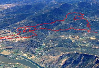
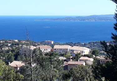
Ruta A pie de 6,7 km a descubrir en Provenza-Alpes-Costa Azul, Var, Roquebrune-sur-Argens. Esta ruta ha sido propuesta por cb8310.
Descripción
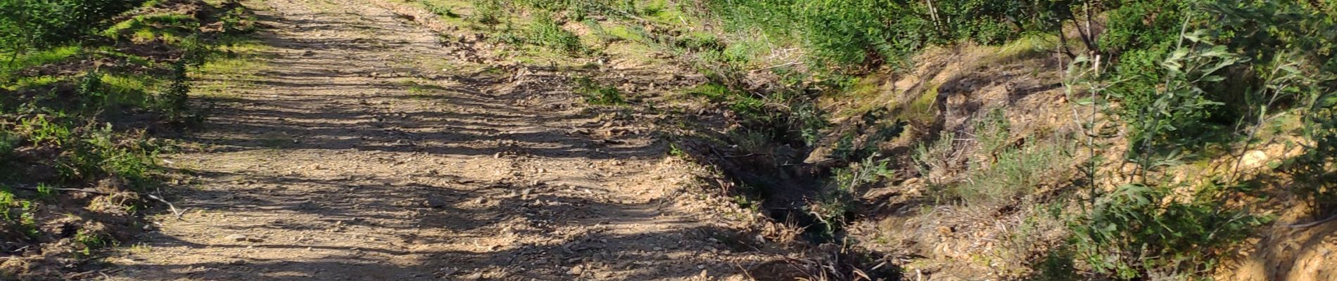
longue montée sur 2 km à travers de petits sentiers,puis larges pistes avec forêt de mimosas et descente
sortie de secours dans le domaine de la Bergerie fermée jusqu'au 4 mars
puis bonne remontée pour accéder aux voitures
Localización
País:
France
Región :
Provenza-Alpes-Costa Azul
Departamento/provincia :
Var
Municipio :
Roquebrune-sur-Argens
Localidad:
Unknown
Salida:(Dec)
Salida:(UTM)
311448 ; 4808431 (32T) N.
Comentarios
Excursiones cerca
![Excursión Senderismo Roquebrune-sur-Argens - SityTrail - Les 25 ponts-Roquebrune sur Argens-28-01-22 - Photo](https://media.geolcdn.com/t/375/260/605c9bb1-f90a-4cd2-a653-fe52e6d3d081.jpg&format=jpg&maxdim=2)
![Senderismo Senderismo](https://static1.geolcdn.com/sitytour/trail-icons/101.png)
SityTrail - Les 25 ponts-Roquebrune sur Argens-28-01-22
Senderismo
Medio
(1)
Roquebrune-sur-Argens,
Provenza-Alpes-Costa Azul,
Var,
France
![](/images/other/stat-length.png)
14,4 km | 20 km-effort
6h 0min
![](https://static1.geolcdn.com/siteimages/upload/files/16400158638029165_repeat_loop_refresh_sync_direction_icon.png)
Sí
![Excursión Senderismo Fréjus - Etang de Villepey - Photo](https://media.geolcdn.com/t/375/260/ext.jpg?maxdim=2&url=https%3A%2F%2Fservices.sitytrail.com%2FGeolivesWS%2FDownloadMedia.ashx%3FTrailID%3D734327%26Media%3Dfix__20170416160746.jpg)
![Senderismo Senderismo](https://static1.geolcdn.com/sitytour/trail-icons/101.png)
Etang de Villepey
Senderismo
Muy fácil
(2)
Fréjus,
Provenza-Alpes-Costa Azul,
Var,
France
![](/images/other/stat-length.png)
6,5 km | 7 km-effort
3h 4min
![](https://static1.geolcdn.com/siteimages/upload/files/16400158638029165_repeat_loop_refresh_sync_direction_icon.png)
Sí
![Excursión Senderismo Roquebrune-sur-Argens - Rocher de Roquebrune, les Trois Croix - Photo](https://media.geolcdn.com/t/375/260/ext.jpg?maxdim=2&url=https%3A%2F%2Fservices.sitytrail.com%2FGeolivesWS%2FDownloadMedia.ashx%3FTrailID%3D173163%26Media%3D14736_1.jpg)
![Senderismo Senderismo](https://static1.geolcdn.com/sitytour/trail-icons/101.png)
Rocher de Roquebrune, les Trois Croix
Senderismo
Difícil
(4)
Roquebrune-sur-Argens,
Provenza-Alpes-Costa Azul,
Var,
France
![](/images/other/stat-length.png)
7 km | 11,4 km-effort
4h 15min
![](https://static1.geolcdn.com/siteimages/upload/files/16400158638029165_repeat_loop_refresh_sync_direction_icon.png)
Sí
![Excursión Senderismo Roquebrune-sur-Argens - 2023-10-25_17h14m36_Randonn_e-27 - Photo](https://media.geolcdn.com/t/375/260/ext.jpg?maxdim=2&url=https%3A%2F%2Fstatic1.geolcdn.com%2Fsiteimages%2Fupload%2Ffiles%2F1553511878bg_sport_marche.png)
![Senderismo Senderismo](https://static1.geolcdn.com/sitytour/trail-icons/101.png)
2023-10-25_17h14m36_Randonn_e-27
Senderismo
Difícil
(1)
Roquebrune-sur-Argens,
Provenza-Alpes-Costa Azul,
Var,
France
![](/images/other/stat-length.png)
9,2 km | 12,6 km-effort
2h 52min
![](https://static1.geolcdn.com/siteimages/upload/files/16400158638029165_repeat_loop_refresh_sync_direction_icon.png)
Sí
![Excursión Senderismo Roquebrune-sur-Argens - Autour de la Maurette (variante) - Photo](https://media.geolcdn.com/t/375/260/9e327cd4-b701-4d2e-839f-23509b76ff37.jpg&format=jpg&maxdim=2)
![Senderismo Senderismo](https://static1.geolcdn.com/sitytour/trail-icons/101.png)
Autour de la Maurette (variante)
Senderismo
Muy difícil
Roquebrune-sur-Argens,
Provenza-Alpes-Costa Azul,
Var,
France
![](/images/other/stat-length.png)
16,5 km | 23 km-effort
4h 10min
![](https://static1.geolcdn.com/siteimages/upload/files/16400158638029165_repeat_loop_refresh_sync_direction_icon.png)
Sí
![Excursión A pie Roquebrune-sur-Argens - Roquebrune sur argens-Les 25 Ponds-ND de la pitié- Lac des clos - Photo](https://media.geolcdn.com/t/375/260/ext.jpg?maxdim=2&url=https%3A%2F%2Fstatic1.geolcdn.com%2Fsiteimages%2Fupload%2Ffiles%2F1545311037marcheuse_200dpi.jpg)
![A pie A pie](https://static1.geolcdn.com/sitytour/trail-icons/100.png)
Roquebrune sur argens-Les 25 Ponds-ND de la pitié- Lac des clos
A pie
Fácil
(1)
Roquebrune-sur-Argens,
Provenza-Alpes-Costa Azul,
Var,
France
![](/images/other/stat-length.png)
11,9 km | 17 km-effort
3h 51min
![](https://static1.geolcdn.com/siteimages/upload/files/16400158638029165_repeat_loop_refresh_sync_direction_icon.png)
Sí
![Excursión Senderismo Roquebrune-sur-Argens - 200526 Les Issambres - Photo](https://media.geolcdn.com/t/375/260/ext.jpg?maxdim=2&url=https%3A%2F%2Fstatic1.geolcdn.com%2Fsiteimages%2Fupload%2Ffiles%2F1553511878bg_sport_marche.png)
![Senderismo Senderismo](https://static1.geolcdn.com/sitytour/trail-icons/101.png)
200526 Les Issambres
Senderismo
Medio
(1)
Roquebrune-sur-Argens,
Provenza-Alpes-Costa Azul,
Var,
France
![](/images/other/stat-length.png)
8,3 km | 12,2 km-effort
2h 33min
![](https://static1.geolcdn.com/siteimages/upload/files/16400158638029165_repeat_loop_refresh_sync_direction_icon.png)
Sí
![Excursión Senderismo Roquebrune-sur-Argens - les hauts de Roquebrune sur Argens - Photo](https://media.geolcdn.com/t/375/260/fb3b5c94-db8e-400d-a9b2-b3a4bc6a654b.jpg&format=jpg&maxdim=2)
![Senderismo Senderismo](https://static1.geolcdn.com/sitytour/trail-icons/101.png)
les hauts de Roquebrune sur Argens
Senderismo
Fácil
(1)
Roquebrune-sur-Argens,
Provenza-Alpes-Costa Azul,
Var,
France
![](/images/other/stat-length.png)
6,2 km | 8,9 km-effort
2h 9min
![](https://static1.geolcdn.com/siteimages/upload/files/16400158638029165_repeat_loop_refresh_sync_direction_icon.png)
Sí
![Excursión Senderismo Roquebrune-sur-Argens - la Gaillarde - Photo](https://media.geolcdn.com/t/375/260/125c2b5e-47e1-41cd-9dff-65f7af0300f6.jpg&format=jpg&maxdim=2)
![Senderismo Senderismo](https://static1.geolcdn.com/sitytour/trail-icons/101.png)
la Gaillarde
Senderismo
Fácil
Roquebrune-sur-Argens,
Provenza-Alpes-Costa Azul,
Var,
France
![](/images/other/stat-length.png)
6,5 km | 10,1 km-effort
1h 59min
![](https://static1.geolcdn.com/siteimages/upload/files/16400158638029165_repeat_loop_refresh_sync_direction_icon.png)
Sí